Tornado Watch Looks Likely For The Southwestern Parts Of The Area & Back Into Southern Mississippi
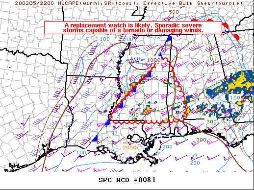
From the latest SPC Mesoscale Discussion…
Scattered storms, some capable of a brief tornado or damaging wind gusts, remain possible this evening.
DISCUSSION
Numerous storms persist both along and ahead of a cold front, affecting much of MS, AL, and southern Middle TN. Shear remains strong with the most favorable hodographs from parts of eastern MS and into northern AL.
Lift via warm advection will remain strongest over northern areas, but lift along the cold front and a moist and marginally unstable air mass will conditionally favor severe storms through evening over much of MS and into parts of southern AL. As such, a replacement watch will likely be required.
Category: Alabama's Weather, ALL POSTS, Severe Weather
About the Author (Author Profile)
Scott Martin is an operational meteorologist, professional graphic artist, musician, husband, and father. Not only is Scott a member of the National Weather Association, but he is also the Central Alabama Chapter of the NWA president. Scott is also the co-founder of Racecast Weather, which provides forecasts for many racing series across the USA. He also supplies forecasts for the BassMaster Elite Series events including the BassMaster Classic.Subscribe
If you enjoyed this article, subscribe to receive more just like it.


