

A Brief Shower Possible Tomorrow; Next Week Looks Mighty Damp
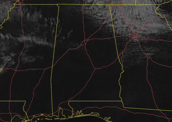
As of 2:30 pm this afternoon, the visible satellite image shows plenty of sun across nearly all of Central Alabama with the exception of a few stray clouds over the western parts of the area along with a stubborn cluster of clouds in the northeastern parts.
Temperatures were in the 40s for the most part across the area as of 2:00 pm. Montgomery was the only spot in the fifties at 50 degrees. Gadsden was the cold spot at 40 degrees. Birmingham nearly splits the difference at 44 degrees.
Radar is free from any precipitation as you would expect with the sun shining, and it should stay that way for the remainder of your Friday.

Unfortunately, the rainfall amounts have trended upward for next week with these latest model runs. WPC is forecasting between 4 to 7 inches of rainfall from now until midday on Friday. That is a 1-inch increase from this morning’s video forecast. I guess it’s time to see if Noah is ready with the ark.
Rest Of Today
We’ll continue to have mostly clear to sunny skies throughout the area until sunset with temperatures falling into the upper 30s to the mid-40s around 6:00 pm. We’ll have some clouds move across the area for tonight through the overnight hours, but we’ll remain dry. Lows will be in the lower 30s to right at or just over 40 degrees.
The Central Alabama Weekend
On Saturday, a small and quick-moving disturbance may bring a few light showers across the area, but the lower levels of the atmosphere will be dry, so most of that may evaporate before making it to the surface. Skies will be partly to mostly cloudy and highs will be in the lower 50s to the lower 60s. The chance of rain will be less than 20%.
Much of the day on Sunday will be partly to mostly sunny across the area, but clouds look to move in late. Rain chances will start to rise after midnight as the next cold front approaches setting up a period of unsettled weather for the workweek. Highs will be in the lower 60s to just below 70 degrees throughout the area.
Next Week
On Monday, the cold front will move into Central Alabama. Ahead of the front, the flow of moist air from the Gulf of Mexico will be increasing which will set the stage for rain and a few thunderstorms, especially for the afternoon and evening hours. Rain could be heavy at times. Highs will be in the lower 60s to the lower 70s.
The front stalls out across Central Alabama on Tuesday which will keep rain and a few thunderstorms likely throughout the daylight hours. Rain chances will decrease a little during the evening hours potentially leading for some locations to have a few hours of no rain. Highs will be in the upper 50s to the lower 70s across the area from northwest to southeast.
The front will finally start moving on Wednesday, but we’ll have another day with rain and a few thunderstorms likely at times. It may take a while for the heavier rain and thunderstorms to move into the area from the west as another impulse approaches. Highs will be in the upper 50s to the mid-60s.
The GFS has agreed with the European model that rain and thunderstorms will continue through Thursday. Rain will be likely at times with some of those thunderstorms dropping heavy rain. Highs will be in the upper 50s to the upper 60s.
Voodoo Land
Taking a quick peek into Voodoo Land for the end of the workweek and the weekend, it looks like we will be dry for Valentine’s Day and the weekend. Temperatures look to be in the upper 50s for highs and lower to mid-40s for lows. Enjoy it while you can as another system looks to move in by early Monday.
Category: Alabama's Weather, ALL POSTS, Weather Xtreme Videos
About the Author (Author Profile)
Scott Martin is an operational meteorologist, professional graphic artist, musician, husband, and father. Not only is Scott a member of the National Weather Association, but he is also the Central Alabama Chapter of the NWA president. Scott is also the co-founder of Racecast Weather, which provides forecasts for many racing series across the USA. He also supplies forecasts for the BassMaster Elite Series events including the BassMaster Classic.Subscribe
If you enjoyed this article, subscribe to receive more just like it.


