Sunshine Returning this Afternoon
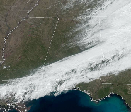
The first half of today as not been very nice, but as we head into the afternoon, the weather is getting better. The clouds, rain, and snow we had across the area this morning, are giving way to sunshine and blue sky this afternoon.
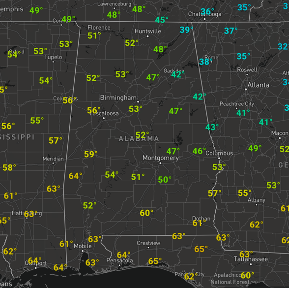
Temperatures have generally been holding in the 30s and 40s as well, but with the sunshine returning, here come the 50s for most locations this afternoon across North/Central Alabama.
Tonight, will feature some passing clouds and cold temperatures with lows ranging from the low to mid 30s.
SUNNY SUNDAY: Tomorrow will be the best day of weather for the weekend, and really the next week. After the cold start, the day will feature more sun than clouds allowing temperatures to warm into the low to mid 60s across North/Central Alabama. Enjoy tomorrow, because it looks to be last dry day for a while for Alabama. Clouds begin to increase late in the day as our next front approaches the area and rain is likely to return overnight Sunday into Monday.
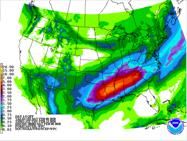
VERY WET WEEK AHEAD: The front moves into Alabama Monday and then stalls across the state, meaning rain and storms are in the forecast each day Monday through Thursday. Now it won’t rain all the time, but waves of low pressure will move up and along the front, and these will enhance rain chances as they move across the state. Expect some thunderstorms, for now, no severe storms, but do expect very heavy rainfall as pricipitable water values for this time of year are going to be very high.
So the forecast Monday through Thursday will feature a cloudy sky with periods of rain and storms. Temperatures will be mild with daytime temps in the mid 60s most days, while nights should be in the 40s and 50s. The rain gear will be an essential part of your wardrobe this week.
RAINFALL/FLOODING: With recent rains and a lot more rain in the forecast, the threat for flooding will be a serious concern for much of the week. For now, there are no active flash flood watches or warnings, the exceptions are the numerous river flood warnings across the state. However, the National Weather Service is already hinting to the possibility of watches being issued as we head into the week, and I would have to agree. For the week ahead, specially between Monday and Thursday, QPF output for rainfall across Alabama is in the 2 to 5 inch rain, with of course isolated higher amounts.
With periods of heavy rainfall expected and saturated grounds, it will not take much to see flooding issues develop at any time this week. So be prepared to deal with these issues this week, and just a reminder if you encounter any floodwaters, TURN AROUND, DON’T DROWN!!!
Additionally, rivers and stream are already running full, with many near or in flood stage, and with the additional rainfall expected, we look to be dealing with a prolonged river flood event across the state. Just something to keep an eye on the next couple of weeks.
BEACH FORECAST CENTER: Get the latest weather and rip current forecasts for the beaches from Fort Morgan to Panama City on our Beach Forecast Center page. There, you can select the forecast of the region that you are interested in visiting.
WORLD TEMPERATURE EXTREMES: Over the last 24 hours, the highest observation outside the U.S. was 110.1F at Cunderdin Airfield, Australia. The lowest observation was -63.2F at Omolon, Russia.
CONTIGUOUS TEMPERATURE EXTREMES: Over the last 24 hours, the highest observation was 87F at Falcon Lake, TX. The lowest observation was -30F at Larch Lake, MN.
WEATHER ON THIS DATE IN 1835: A severe cold wave gripped the southeastern U.S. The mercury dipped to 8 above at Jacksonville FL, and to zero at Savannah GA. Orange trees were killed to the roots.
Category: Alabama's Weather, ALL POSTS
About the Author (Author Profile)
Macon, Georgia Television Chief Meteorologist, Birmingham native, and long time Contributor on AlabamaWX. Stormchaser. I did not choose Weather, it chose Me. College Football Fanatic. @Ryan_StinnetSubscribe
If you enjoyed this article, subscribe to receive more just like it.


