A Watch Is Possible To Our West & Potentially Including Northwestern Parts Of The Area
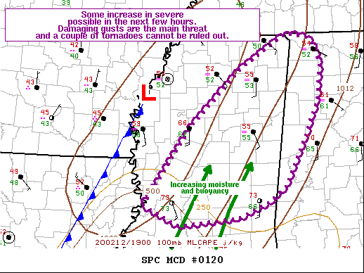
The latest Mesoscale Discussion from the Storm Prediction Center is out and talks about the possibility of a watch coming out for northeast and eastern parts of Mississippi and potentially the extreme western and northwestern parts of North/Central Alabama. Here is the discussion from the SPC:
Probability of Watch Issuance…40 percent
SUMMARY…At least a few severe storms are possible in the next few
hours, going into early evening. Damaging wind gusts appear to be
the primary threat, though a couple of tornadoes cannot be ruled
out. Convective trends are being monitored for the need of a WW.
DISCUSSION…A well defined mid-level trough continues to approach
the southeast states, with a broad low-level mass response promoting
moistening of the low-levels (i.e. a northward surge of upper 60s to
near 70 F dewpoints), particularly across LA into central MS. In
addition, breaks in the clouds from central MS southward have
allowed for some diurnal heating, with temperatures warming into the
mid 70s. Nonetheless, given the overall cloudy conditions, and poor
mid-level lapse rates (mainly under 6 C/km based on latest
mesoanalysis and the latest RAP forecast soundings) across the warm
sector, overall instability is expected to be mediocre. MLCAPE is
expected to be maximized in the 500-1000 J/kg range, and confined
within tall, skinny vertical profiles. As such, robust convection is
expected to be relatively sparse in nature.
Still, deep-layer/low-level speed shear (40+ knots in the 0-1 km
layer) is prevalent across the warm sector, with long, curved
hodographs depicting a favorable kinematic environment for
organized, rotating storms. Flow above 1 km however, appears to be
unidirectional. With deep-layer winds bearing a strong parallel
component of flow to the approaching cold front, much of the
convection is expected to be linear in nature. While a forced line
of convection is expected, the strong low-level speed shear and
modest directional shear (yielding over 400 m2/s2 effective SRH) may
promote the development of a couple of tornadoes, where QLCS
circulations may coincide axes of locally higher buoyancy.
All 12Z HREF members initiate a squall line along the cold front by
20-22Z, though the trend among the latest HRRR runs show less
vigorous convection overall. Given the aforementioned limitations to
the thermodynamic environment and associated weakening trends among
model guidance, confidence in the necessity of a WW issuance remains
modest at this time. Trends will continue to be monitored for a WW
issuance.
Category: Alabama's Weather, ALL POSTS, Severe Weather
About the Author (Author Profile)
Scott Martin is an operational meteorologist, professional graphic artist, musician, husband, and father. Not only is Scott a member of the National Weather Association, but he is also the Central Alabama Chapter of the NWA president. Scott is also the co-founder of Racecast Weather, which provides forecasts for many racing series across the USA. He also supplies forecasts for the BassMaster Elite Series events including the BassMaster Classic.Subscribe
If you enjoyed this article, subscribe to receive more just like it.


