Latest Storm Prediction Center Mesoscale Technical Discussion
Mesoscale Discussion 0122
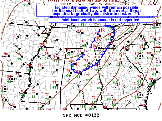
NWS Storm Prediction Center Norman OK
0737 PM CST Wed Feb 12 2020
Areas affected…Portions of central/northern AL into middle/eastern
TN and far northwestern GA
Concerning…Severe Thunderstorm Watch 34…
Valid 130137Z – 130300Z
The severe weather threat for Severe Thunderstorm Watch 34
continues.
SUMMARY…Isolated damaging winds will remain possible for the next
hour or two, with the overall threat expected to gradually diminish
into eastern TN. Additional watch issuance is not expected at this
time.
DISCUSSION…A low-topped squall line will continue its fast
east-northeastward motion across middle/eastern TN this evening.
Isolated instances of strong to damaging winds will be the main
threat with this convection for the next 1-2 hours. Winds in the
boundary layer remain quite strong in association with a 60-70+ kt
low-level jet. However, already meager instability quickly becomes
negligible with eastward extent into eastern TN, where surface
temperatures are in the 40s and 50s F, with dewpoints in the mid 40s
to low 50s. This will likely result in a gradual lessening of the
damaging wind risk into more of eastern TN beyond 03Z. Additional
Severe Thunderstorm Watch issuance into eastern TN/far northwestern
GA is not expected at this time.
Farther south across parts of northern/central AL, the convective
line has become oriented largely parallel to strong mid-level
southwesterly flow. Overall eastward movement of the line has slowed
accordingly. Although strong/gusty winds may still occur in the
short term, the severe risk should continue to diminish this evening
as the strong forcing associated with the low-level jet shifts
northward and away from this region.
..Gleason.. 02/13/2020
Category: Alabama's Weather, ALL POSTS, Severe Weather
About the Author (Author Profile)
Bill Murray is the President of The Weather Factory. He is the site's official weather historian and a weekend forecaster. He also anchors the site's severe weather coverage. Bill Murray is the proud holder of National Weather Association Digital Seal #0001 @wxhistorianSubscribe
If you enjoyed this article, subscribe to receive more just like it.


