

Flash Flooding Possible Across Portions of Central Alabama Through Tonight
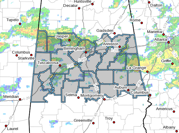
NWS Birmingham has issued a FLASH FLOOD WATCH from 7:00 am this morning through 6:00 am Wednesday for a good portion of Central Alabama. Here is a list of counties covered by the watch: Autauga, Bibb, Calhoun, Chambers, Chilton, Clay, Cleburne, Coosa, Elmore, Fayette, Greene, Hale, Jefferson, Lamar, Lee, Perry, Pickens, Randolph, Shelby, St. Clair, Sumter, Talladega, Tallapoosa, Tuscaloosa, and Walker counties.
Flash Flooding Possible Across Portions of Central Alabama Through Tonight
Several rounds of showers and storms will slide over portions of Central ahead of a cold front that will move through later tonight. Several locations within the watch have already received between 1/2 and 1 inch of rain so far since Midnight with an additional 1.5 to 2.5 inches expected over the next 18 to 24 hours. Locally higher totals will be possible along and south of the I-20 corridor.
A Flash Flood Watch means that conditions may develop that lead to flash flooding. Flash flooding is a very dangerous situation.
You should monitor later forecasts and be prepared to take action should Flash Flood Warnings be issued.
Category: Alabama's Weather, ALL POSTS, Severe Weather
About the Author (Author Profile)
Scott Martin is an operational meteorologist, professional graphic artist, musician, husband, and father. Not only is Scott a member of the National Weather Association, but he is also the Central Alabama Chapter of the NWA president. Scott is also the co-founder of Racecast Weather, which provides forecasts for many racing series across the USA. He also supplies forecasts for the BassMaster Elite Series events including the BassMaster Classic.Subscribe
If you enjoyed this article, subscribe to receive more just like it.


