Satellite Sheldon: Fall 2019 Through Winter 2020 Heavy Precipitation Events
I don’t have to tell you how wet Mississippi, Alabama, and parts of the Southeast US have been the last 6 months. We all know about the Pearl River flooding from last week and over the last month or so. Maybe not so much about any flooding in Alabama. at least you are now more educated on what it takes to produce historic flooding from high amounts of precipitation over the past six months centered on Mississippi. – Sheldon Kusselson.
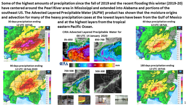
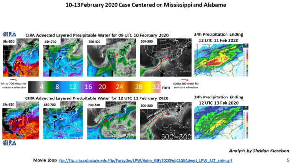
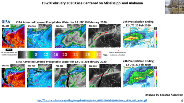
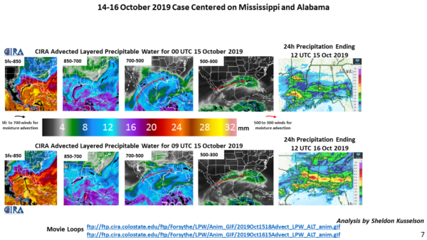
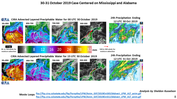
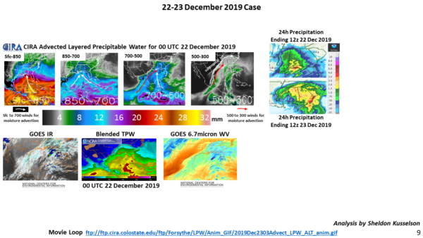
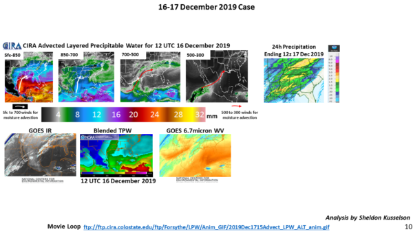
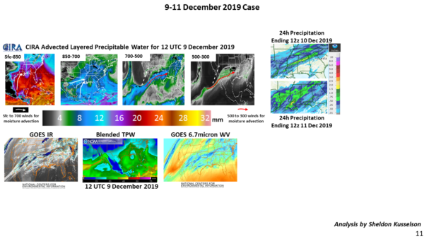
Some of the highest amounts of precipitation since the fall of 2019 and the recent flooding this winter (2019-20) have centered around the Pearl River area in Mississippi and extended into Alabama and portions of the southeast US. The Advected Layered Precipitable Water (ALPW) product has shown that the moisture origins and advection for many of the heavy precipitation cases at the lowest layers have been from the Gulf of Mexico and at the highest layers from the tropical eastern Pacific Ocean.
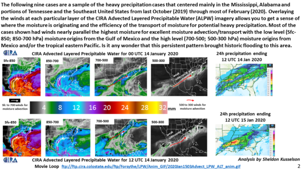
The following nine cases are a sample of the heavy precipitation cases that centered mainly in the Mississippi, Alabama, and portions of Tennessee and the Southeast United States from last October (2019) through most of February (2020). Overlaying the winds at each particular layer of the CIRA Advected Layered Precipitable Water (ALPW) imagery allows you to get a sense of where the moisture is originating and the efficiency of the transport of moisture for potential heavy precipitation. Most of the cases shown had winds nearly parallel the highest moisture for excellent moisture advection/transport with the low level (SFC-850; 850-700 hPa) moisture origins from the Gulf of Mexico and the high level (700-500; 500-300 hPa) moisture origins from Mexico and/or the tropical eastern Pacific. Is it any wonder that this persistent pattern brought historic flooding to this area.
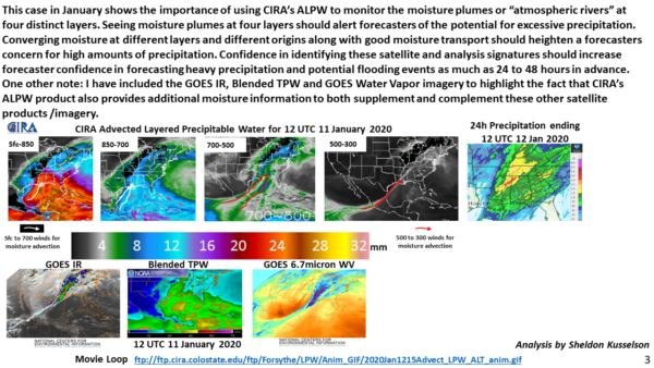
This case in January shows the importance of using CIRA’s ALPW to monitor the moisture plumes or “atmospheric rivers” at four distinct layers. Seeing moisture plumes at four layers should alert forecasters of the potential for excessive precipitation. Converging moisture at different layers and different origins along with good moisture transport should heighten a forecaster’s concern for high amounts of precipitation. Confidence in identifying these satellite and analysis signatures should increase forecaster confidence in forecasting heavy precipitation and potential flooding events as much as 24 to 48 hours in advance.
One other note: I have included the GOES IR, Blended TPW and GOES Water Vapor imagery to highlight the fact that CIRA’s ALPW product also provides additional moisture information to both supplement and complement these other satellite products /imagery.
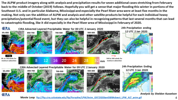
The ALPW product imagery along with analysis and precipitation results for seven additional cases stretching from February back to the middle of October (2019) follows. Hopefully, you will get a sense that major flooding this winter in portions of the Southeast U.S. and in particular Alabama, Mississippi and especially the Pearl River area were at least five months in the making. Not only can the addition of ALPW and analysis and other satellite products be helpful for each individual heavy precipitation/potential flood event, but they can also be helpful in recognizing patterns that last several months that can lead to catastrophic flooding as it did especially in the Pearl River area of Mississippi in February of 2020.
Category: Alabama's Weather, ALL POSTS, Met 101/Weather History
About the Author (Author Profile)
Scott Martin is an operational meteorologist, professional graphic artist, musician, husband, and father. Not only is Scott a member of the National Weather Association, but he is also the Central Alabama Chapter of the NWA president. Scott is also the co-founder of Racecast Weather, which provides forecasts for many racing series across the USA. He also supplies forecasts for the BassMaster Elite Series events including the BassMaster Classic.Subscribe
If you enjoyed this article, subscribe to receive more just like it.


