Dry/Mild Today; Colder Tomorrow With A Few Showers
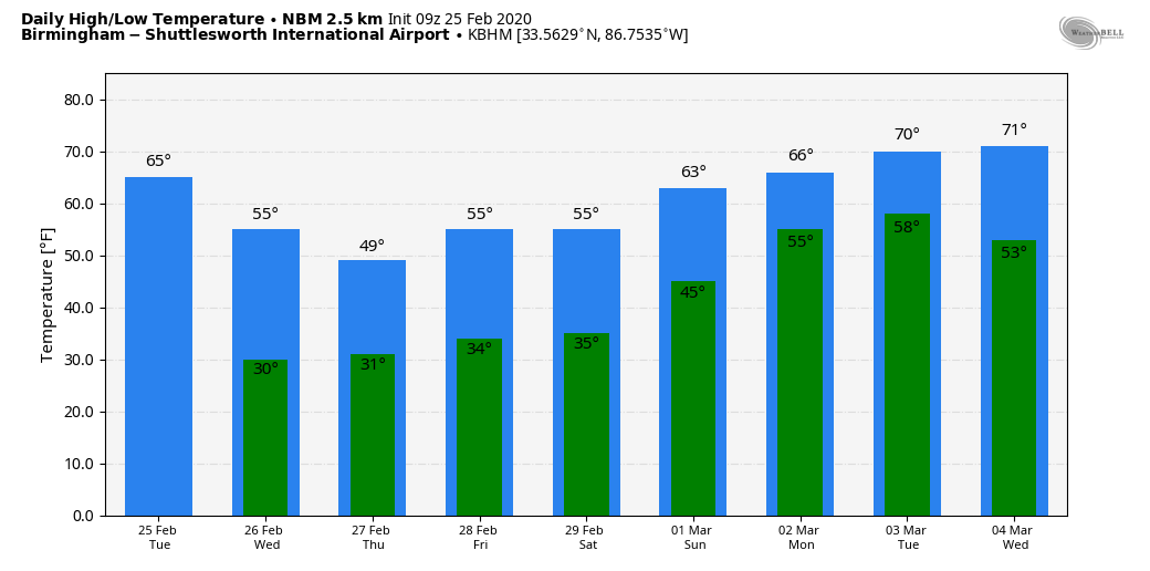
DRIER DAY: With a mix of sun and clouds, we project a high in the upper 60s across North/Central Alabama this afternoon. South Alabama will likely see low 70s today for a nice preview of spring. Any showers should be confined to the southeast counties of the state through tonight.
But tomorrow a cold front passes through, bringing clouds, cooler temperatures, and a few showers. Rain amounts tomorrow will be light and spotty… under a tenth of an inch for most places. The high will be close to 50 degrees, and a brisk northwest wind will make it feel cooler following the front’s passage tomorrow afternoon.
FLURRIES? High resolution models hint we might see a few snow flurries in the colder air over North Alabama tomorrow night, but moisture will be very limited, and there will be no impact if a snow flake falls.
THURSDAY/FRIDAY: These two days will be dry with cold mornings, morning lows will be in the 28-32 degree range; the high Thursday will be close to 50, followed by mid 50s Friday. Clouds will increase Friday night ahead of a disturbance riding down the back side of an upper trough over the eastern U.S.
This feature has potential to squeeze out a little light snow, or snow flurries over the northeast corner of Alabama Friday night and very early Saturday morning. Once again, moisture will be limited, and no significant impact is expected for now. But, it is possible a few spots across higher terrain could get a “dusting” for brief time.
THE ALABAMA WEEKEND: Flurries over far Northeast Alabama should end early in the day Saturday… otherwise the day will be dry with a partly to mostly sunny sky along with a high in the low 50s. Sunday will be a mostly sunny day with a very nice warm-up. After starting the day around freezing, the high Sunday afternoon will be in the low to mid 60s.
NEXT WEEK: Moisture levels rise early in the week… Monday and Tuesday will be mostly cloudy and mild with a chance of showers. We will be in the 60s Monday, and low 70s are likely Tuesday. A weather system will bring rain and possibly strong thunderstorms to the state Wednesday… See the Weather Xtreme video for maps, graphics, and more details.
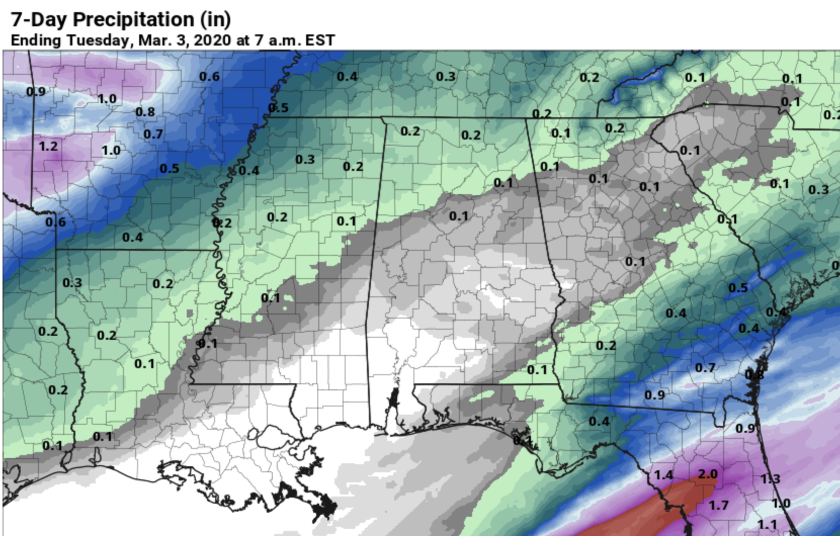
DRIER PATTERN: The QPF (quantitative precipitation forecast) from NOAA’s WPC for the next seven days (through Tuesday March 3) is the driest we have seen this year for Alabama. Amounts over the northern half of the state are forecast to be under a quarter of an inch… and much of South Alabama will be dry.
RAIN UPDATE: Birmingham’s official rain total for the month of February so far is 13.12?. That makes 2020 the third wettest February on record… behind February 1961 (17.67?) and February 1903 (15.86?). Current rain projections for the next seven days suggest February 2020 will most likely stay in third place.
ON THIS DATE IN 1934: An outbreak of six tornadoes killed nineteen in Mississippi, Alabama, and Georgia. Hardest hit was Bowden, GA, and Shady Grove, AL. One home in Lauderdale County, Mississippi, was picked up, thrown 400 feet, and blown to bits. Six family members were killed in the house.
ON THIS DATE IN 2015: many Alabamians experienced one of the largest snow storms on record as over 12 inches of snow were unofficially measured along the Highway 278 corridor in Marion County. In addition, much of the northern two-thirds of the state saw snow during the afternoon and evening hours of the 25th, with totals of 1 – 2 inches near Interstate 20 increasing to 5 – 12 inches further north to the Tennessee state line. The highest unofficial measurement came from Guin, Alabama, with 12.7 inches. While most of Central Alabama was disappointed as only rain fell, some experienced one of the largest snowfalls on record that won’t be soon forgotten.
BEACH FORECAST: Click here to see the AlabamaWx Beach Forecast Center page.
WEATHER BRAINS: Don’t forget you can listen to our weekly 90 minute show anytime on your favorite podcast app. This is the show all about weather featuring many familiar voices, including our meteorologists here at ABC 33/40.
CONNECT: You can find me on all of the major social networks…
Facebook
Twitter
Instagram
Pinterest
Snapchat: spannwx
I have a weather program this morning at Gordo High School… look for the next Weather Xtreme video here by 4:00 this afternoon. Enjoy the day!
Category: Alabama's Weather, ALL POSTS, Weather Xtreme Videos
About the Author (Author Profile)
James Spann is one of the most recognized and trusted television meteorologists in the industry. He holds the AMS CCM designation and television seals from the AMS and NWA. He is a past winner of the Broadcast Meteorologist of the Year from both professional organizations.Subscribe
If you enjoyed this article, subscribe to receive more just like it.


