Oh So Nice Leap Day
Overall this 29th day of February is certainly a nice one across the state.
It was a chilly and frosty start to the day, but with a sunny sky, we are seeing highs surge into the 50s this afternoon, with some 60s showing up as well.
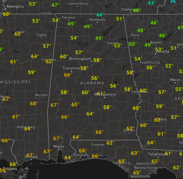
Not at all a bad final day of February across Alabama. Tonight will be generally clear and calm, another chilly one and by tomorrow morning, lows will be in the upper 30s for most locations across North/Central Alabama.
WARMER TOMORROW: Our Sunday will yet again be a dry one, and enjoy it as rain chances will be increasing Sunday night. The day itself will feature more sun than clouds and we will see a nice warm up as southwesterly winds help surge our temperatures into the 60s area wide tomorrow afternoon, with likely 70s on the maps as well. Moisture starts returning late in the day, and overnight Sunday, clouds and rain chances return.
MONDAY/TUESDAY: Southerly flow overtakes the state allowing moisture to stream north into the state and with an approaching front from the northwest, our weather turns wet/unsettled for the new work week. These two days will feature more clouds than sun, with widespread and numerous showers especially across the northern half of the state. These day will be mild with highs in the upper 60s Monday, and low to mid 70s Tuesday. On Tuesday, the SPC maintains a severe weather risk west of Alabama in their “Day 4 Convective Outlook” from Deep South Texas, east to the Mississippi/Alabama state line, but for now no part of Alabama is included in the risk.

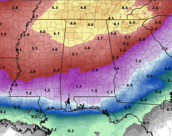
STORMY MIDWEEK: As the front sinks into the state and stalls across North Alabama, we will see waves of heavy rain and storms track long the front during this timeframe. Still not enough model consistency to know if severe weather will be an issue for the state, it all depends on where the front stalls across the state. We should see a low develop and lift northeast along the frontal boundary, and south of the low, we should see the threat of strong to possibly severe storms for areas of Alabama, and for now, the main area of concern with be over the southern half of the state, so basically along and south of Interstate 20. Again still too much uncertainty to know if this will occur, and we will note, that as of today, the SPC continues to not include any part of Alabama in a risk for severe weather Wednesday, but again this could change in the coming days. Severe storms or not, the real concern next week looks to be yet another potential flood threat for Alabama, as rain amounts in the 3-5 inch range are likely over the northern half of Alabama through Wednesday night.
BEACH FORECAST CENTER: Get the latest weather and rip current forecasts for the beaches from Fort Morgan to Panama City on our Beach Forecast Center page. There, you can select the forecast of the region that you are interested in visiting.
WORLD TEMPERATURE EXTREMES: Over the last 24 hours, the highest observation outside the U.S. was 109.4F at Laverton, Australia. The lowest observation was -75.8F at Summit, Greenland.
CONTIGUOUS TEMPERATURE EXTREMES: Over the last 24 hours, the highest observation was 91F at Yorba Linda and Anaheim, CA. The lowest observation was -18F at Sea Gull Lake, MN.
WEATHER ON THIS DATE IN 2008: The world’s tallest snowwoman is unveiled in the western Maine town of Bethel, ME. “Olympia,” named for Maine Senator Olympia Snowe, is about 122 feet tall, 10 feet taller than “Angus, King of the Mountain,” which has held the tallest snowman record since 1999. He was named for Angus King, Maine’s governor at the time.
Category: Alabama's Weather, ALL POSTS
About the Author (Author Profile)
Macon, Georgia Television Chief Meteorologist, Birmingham native, and long time Contributor on AlabamaWX. Stormchaser. I did not choose Weather, it chose Me. College Football Fanatic. @Ryan_StinnetSubscribe
If you enjoyed this article, subscribe to receive more just like it.


