Rain to Return to Alabama Tonight, Flooding Will Once Again Be A Concern
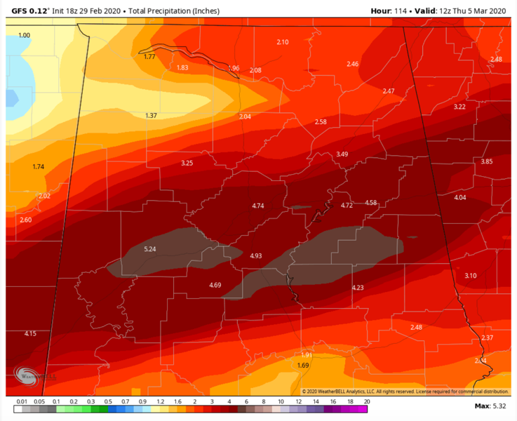
Five day rainfall totals through Thursday morning off the GFS model
Leap Day 2020 was a quiet one nationally and a fine day here across Central Alabama. Bright sunshine under clear skies allowed the mercury to warm nicely from lows in the 30s into the 60s south of US-78/280, with some upper 50s over northeastern sections. Temperatures this morning are in the 30s in all but the far southwestern sections of the area. The coldest temperatures are over northeastern Alabama, where readings near freezing are being observed. More rain is on the way for Alabama, and it could be excessive again, but as for today, it will be a nice one.
ON THE WEATHER MAPS: In the upper atmosphere this morning, we find a split flow across the United States. A deep trough in the southern branch is swinging down into the western U.S. and across the Gulf of Mexico. The northern branch is spreading across the Great Lakes and carving out a trough over New England. At the surface, we find high pressure centered near Asheville, North Carolina. A southerly surface flow is increasing across the South. The trough over the West will be our major weathermaker in the week ahead.
FOR YOUR SUNDAY: Temperatures are starting off in the 30s this morning under partly cloudy skies. A warming late winter sun will quickly push temperatures into the 60s by mid-afternoon. Readings will flirt with 70F along US-80 between Demopolis and Montgomery. Skies will become cloudy this evening, and overnight lows will be in the 40s to near 50F. Showers will start moving into the area late tonight, with most of the rain arriving after midnight. A soaking rain should be in progress in the I-20 Corridor by Monday morning.
ANOTHER RAINY DAY AND MONDAY: Waves of rain with some embedded thunder will be the rule for Monday and Monday night. Nothing severe here in Alabama, but the SPC does think there could be a few severe storms to our northwest, in an area centered near Memphis. Highs on Monday will range from the lower 60s over Northeast Alabama, to the middle and upper 60s the further southwest that you go. Monday night lows will be in the upper 50s to lower 60s.
INTO TUESDAY: Even more moisture surges into Alabama on Tuesday and Tuesday night, even as the cold front approaches from the northwest. The result will be additional waves of rain and embedded thunder. Highs will top out in the upper 60s to lower 70s. The severe weather threat should remain to the west of Alabama, but we can’t rule out that issue just yet for us for late Tuesday night as the approaching trough and front along with increasing instability triggers some stronger storms.
BIGGER THREAT IS FLOODING: The rainfall will once again be piling up by Tuesday night, with 3-4 inch amounts common. This could result in more flooding issues across the area.
WEDNESDAY: The front should be along or south of I-20 by noon on Wednesday, with the main rain and storms over areas south of Birmingham. Northern areas may get a respite from the rain. Highs will be in the upper 50ss to middle 60s.
A NEW SURFACE LOW: Will another surface low manage to form and ripple along the stationary surface front over Alabama late Wednesday into Thursday. That looks like a definite possibility. It would throw another inch or more on the old rainfall totals if it did.
RAIN MOVES OUT FOR THE WEEKEND: The rain should diminish Thursday and Friday into the weekend look mild with a decent amount of sunshine each day. Highs will be in the 60s, lows in the 40s.
NEXT RAIN: Our next rainfall chances will come around Tuesday, March 10th.
VOODOO: Looks like a strong little storm system will arrive around Monday the 16th with a chance of rain and strong storms.
BEACHCAST: A mild week ahead along the beautiful beaches of Alabama and Northwest Florida. Rain will be possible Monday and likely on Tuesday. Storms will be involved at times. Expect dense sea fog Monday night. The rip current risk will be high today and Monday. Highs will be in the 60s and 70s all week. Lows will be in the 50s and 60s. Water temperatures are running in the upper 50s.
Click here to see the Beach Forecast Center page.
NATIONALLY: Winter weather advisories and winter storm warnings are in effect across the west as out big trough triggers fairly good snows across the region. Gale warnings are in effect along almost the entire California Coast, with wind advisories inland. A high wind watch is in effect for the Guadalupe Mountains of southern New Mexico and western Texas.
DANCING WITH THE STATS: The 30 day rainfall total the Birmingham Shuttlesworth International Airport is 13.3 inches, which is 9 inches above normal. The 90 day is 26 inches, which is 12.2 inches above normal.
ADVERTISE WITH US: Deliver your message to a highly engaged audience by advertising on the AlabamaWX.com website. The site enjoyed 2.4 MILLION pageviews last month alone! Don’t miss out! We can customize a creative, flexible and affordable package that will suit your organization’s needs. Contact me, Bill Murray, at (205) 687-0782 and let’s talk.
WEATHERBRAINS: This week, the panel will entertain Dr. Victor Gensini, a meteorologist at Northern Illinois University. He recently got some press for running a weather model on a $50 computer. Check out the show at www.WeatherBrains.com. You can also subscribe on iTunes. You can watch the show live at live.bigbrainsmedia.com or on James’ YouTube Channel You will be able to see the show on the James Spann 24×7 weather channel on cable or directly over the air on the dot 2 feed.
ON THIS DATE IN 1952: In the morning, William Eads of England AR was admonishing his family to finish the building of a storm cellar project that had been underway for weeks. Just after 5 PM, as the finishing touches were being put on the storm cellar, it was put to good use by the family as an F4 tornado devastated the town. This would be Arkansas’ most deadly tornado outbreak ever as 112 people died. At least 6 major tornadoes occurred across the state on this date. Hardest hit was Judsonia AR, where 30 people died. 29 died in Cotton Plant AR. Follow my weather history tweets on Twitter. I am @wxhistorian at Twitter.com.
Category: Alabama's Weather, ALL POSTS
About the Author (Author Profile)
Bill Murray is the President of The Weather Factory. He is the site's official weather historian and a weekend forecaster. He also anchors the site's severe weather coverage. Bill Murray is the proud holder of National Weather Association Digital Seal #0001 @wxhistorianSubscribe
If you enjoyed this article, subscribe to receive more just like it.


