Satellite Sheldon’s Take On The Heavy Rain For Central Alabama This Week
Satellite Sheldon is back and is showing us where the moisture will be coming from that will increase the chances of heavy rain for mid-week and the potential for some flooding issues. Here are the details from his findings:
Pattern of High-Level Moisture From Tropical Eastern Pacific and Low-Level Moisture From Gulf of Mexico Since October 2019
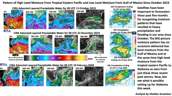
Satellites have been important to forecasters these past five months for recognizing moisture patterns that have resulted in heavy precipitation and flooding in our area since October. The BIG picture moisture pattern has on occasion delivered low-level moisture from the Gulf of Mexico and at the same time high-level moisture from the tropical eastern Pacific to Alabama as seen from just these three recent past storms. Now, let’s see what is possibly setting up for Alabama this week.
Same Pattern of High-Level Moisture From Tropical Eastern Pacific and Low-Level Moisture From the Gulf of Mexico That Has Been Seen Since October 2019, Setting Up for This Week’s Heavy Precipitation and Potential Flooding
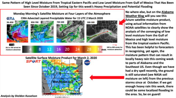
Nowhere else, but on the Alabama Weather Blog will you see this future satellite moisture product, using actual information from NOAA satellites to clearly show the analysis of the converging of low-level moisture from the Gulf of Mexico and high-level moisture from the tropical eastern Pacific. This has been helpful to forecasters in recognizing, yet again, the moisture pattern that can result in locally heavy rain this coming week to parts of Alabama and the Southeast US. Even though we have had a dry spell recently, the ground is still saturated (see NASA soil moisture on left) from the previous storms since October. If we get enough heavy rain this week, there could be some localized flooding in the area. So, be on guard!
Category: Alabama's Weather, ALL POSTS, Met 101/Weather History
About the Author (Author Profile)
Scott Martin is an operational meteorologist, professional graphic artist, musician, husband, and father. Not only is Scott a member of the National Weather Association, but he is also the Central Alabama Chapter of the NWA president. Scott is also the co-founder of Racecast Weather, which provides forecasts for many racing series across the USA. He also supplies forecasts for the BassMaster Elite Series events including the BassMaster Classic.Subscribe
If you enjoyed this article, subscribe to receive more just like it.


