Satellite Sheldon Shares Information About Our Excessive Rainfall
Satellite Sheldon is back this morning sharing some great information on where our excessive moisture has come from over the past five months…
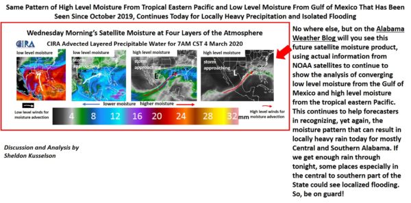
Same Pattern of High-Level Moisture from Tropical Eastern Pacific and Low-Level Moisture from the Gulf of Mexico That Has Been Seen Since October 2019, Continues Today for Locally Heavy Precipitation and Isolated Flooding
Nowhere else but on the Alabama Weather Blog will you see this future satellite moisture product using actual information from NOAA satellites to continue to show the analysis of converging low-level moisture and high-level moisture from the tropical eastern Pacific.
This continues to help forecasters in recognizing, yet again, the moisture pattern that can result in locally heavy rain today and mostly for Central and South Alabama. If we can get enough rain through tonight, some places especially in the central to southern parts of the state could see localized flooding. So, be on guard!
Category: Alabama's Weather, ALL POSTS, Met 101/Weather History
About the Author (Author Profile)
Scott Martin is an operational meteorologist, professional graphic artist, musician, husband, and father. Not only is Scott a member of the National Weather Association, but he is also the Central Alabama Chapter of the NWA president. Scott is also the co-founder of Racecast Weather, which provides forecasts for many racing series across the USA. He also supplies forecasts for the BassMaster Elite Series events including the BassMaster Classic.Subscribe
If you enjoyed this article, subscribe to receive more just like it.


