At Midday, Rain Is The Word; A Few Strong Storms Remain Possible
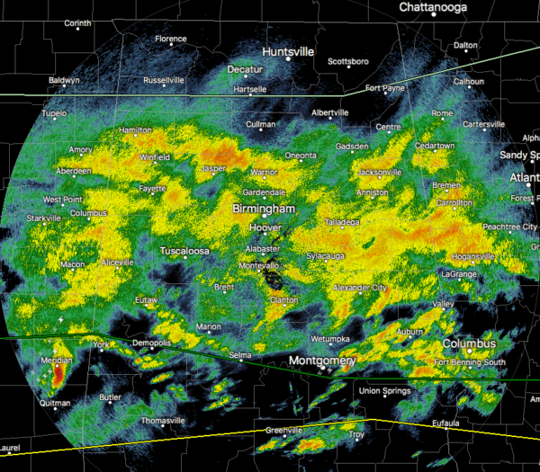
As of 11:34 am, we have a large shield of light to moderate rainfall over much of Central Alabama and up into North Alabama. We do not have any stronger storms occurring in the area at the moment, but we are watching a strong storm moving toward Sumter County that is currently south of Meridian, Mississippi. This storm is producing a good bit of lightning along with gusty winds and very heavy rainfall. We’ll need to keep watching it as it gets closer to the state line.
Temperatures as of the 11:00 am Round-Up were in the mid to upper 50s across the area. Birmingham was the cool spot at 53 degrees, the only reporting station not at or above 55 degrees. Montgomery and Selma were tied at 59 degrees as the warm spots.
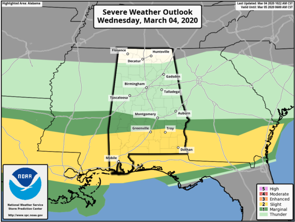
We continue to have the southern portions of Central Alabama in a severe storm risk throughout the rest of the day. A Marginal Risk is up for locations south of a line from Livingston to Selma to Pike Road to Hurtsboro. A Slight Risk clips the southern parts of Pike and Barbour counties along with the southern tip of Bullock County. We still could see isolated damaging winds up to 60 MPH and quarter-size hail, along with a very small, non-zero threat of a tornado in the risk locations.
The good news is that there is not any surface instability to work with across the southern parts of the area, so it would be very difficult for a severe storm to form at this point. Some instability begins to work northward throughout the afternoon hours, but it still looks like it will stay south of Central Alabama.
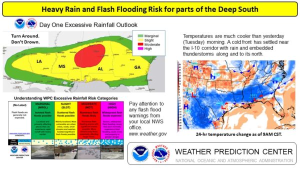
Rain will continue to be widespread throughout the rest of the day and into the night time hours, with a few claps of thunder possible. We may have a strong storm or two over the southern portions of the area, but organized severe weather is not likely. Rainfall could be heavy at times and some flooding issues could occur later today and tonight. Highs will top out in the upper 50s to the mid-60s from north to south. It’s the same story for the overnight hours as lows will only dip into the mid-40s to the lower 50s.
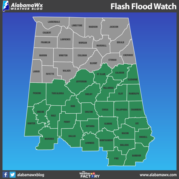
A Flash Flood Watch continues until 12:00 pm Thursday afternoon for nearly all of Central Alabama.
Rain will continue across much of the area during the morning hours on Thursday, but the activity will finally move out of Central Alabama by the early afternoon hours, just in time for the kickoff party for The Bassmaster Classic in Uptown Birmingham by the BJCC. Highs will top out in the upper 50s to the lower 60s, then falling into the mid to upper 50s by 6:00 pm, and into the mid-40s to the lower 50s by 9:00 pm. Overnight lows will dip into the upper 30s to the mid-40s with clearing skies.
Category: Alabama's Weather, ALL POSTS, Severe Weather
About the Author (Author Profile)
Scott Martin is an operational meteorologist, professional graphic artist, musician, husband, and father. Not only is Scott a member of the National Weather Association, but he is also the Central Alabama Chapter of the NWA president. Scott is also the co-founder of Racecast Weather, which provides forecasts for many racing series across the USA. He also supplies forecasts for the BassMaster Elite Series events including the BassMaster Classic.Subscribe
If you enjoyed this article, subscribe to receive more just like it.


