

A Brief Check On Our Weather At Just Before 3:50 PM
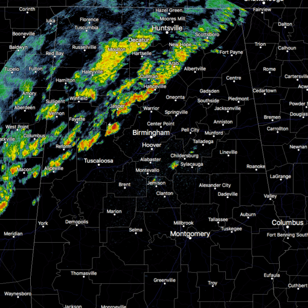
As of 3:35 pm, the leading edge of the line of thunderstorms is now stretching from Aliceville to Hanceville to Scottsboro at the moment. The Marginal Risk for severe storms continues along and ahead of the line from now until around 7:00 pm until we lose the heating of the day. If your location is west of a line from Vernon to Hartselle to Huntsville, the severe threat has really ended, but we could still see a strong elevated storm with brief heavy rain and gusty winds.
We still have a good bit of instability along and ahead on the main line of storms, reaching the 1000-1500 J/kg range. To go along with that, there is a good bit of shear reaching as high as 50-60 knots. The good news is that helicity is well less than needed for supercell production. Therefore, the main severe threats will be from isolated damaging wind gusts up to 60 MPH and hail up to 1-inch in diameter.
At this point, we have had no stronger storms and the activity has well-behaved. We have a little over 3 more hours to watch these storms before we lose the heating of the day and the instability really starts to drop off. We’ll keep you up to date throughout the rest of the afternoon and into the evening.
Category: Alabama's Weather, ALL POSTS, Severe Weather
About the Author (Author Profile)
Scott Martin is an operational meteorologist, professional graphic artist, musician, husband, and father. Not only is Scott a member of the National Weather Association, but he is also the Central Alabama Chapter of the NWA president. Scott is also the co-founder of Racecast Weather, which provides forecasts for many racing series across the USA. He also supplies forecasts for the BassMaster Elite Series events including the BassMaster Classic.Subscribe
If you enjoyed this article, subscribe to receive more just like it.


