Tornado Watch Issued For North Alabama & Extreme Northwestern Parts Of Central Alabama
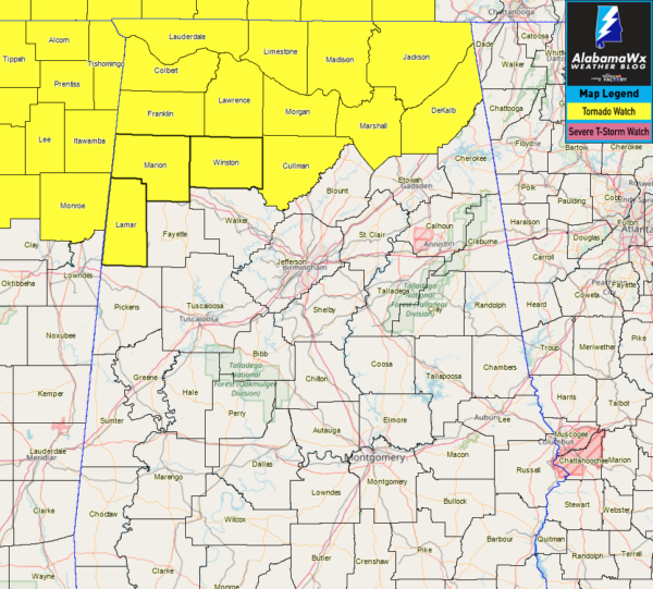
North Alabama counties: Colbert, Cullman, DeKalb, Franklin, Jackson, Lauderdale, Lawrence, Limestone, Madison, Marshall, and Morgan.
Central Alabama counties: Lamar, Marion, and Winston.
The NWS Storm Prediction Center has issued a
Tornado Watch for portions of
Northern Alabama
Northeastern Mississippi
The southern half of western and middle Tennessee
Effective this Tuesday afternoon and evening from 305 PM until 1000 PM CDT.
Primary threats include…
A few tornadoes likely with a couple intense tornadoes possible
Scattered damaging wind gusts to 70 mph likely
Scattered large hail events to 1.5 inches in diameter possible
SUMMARY…Scattered supercell development is expected in the next couple of hours from western Tennessee and northeastern Mississippi into northern Alabama and southern middle Tennessee. The storm environment will be favorable for tornadoes, including a strong tornado or two, in addition to damaging winds and large hail. Storms will spread eastward through late evening.
PRECAUTIONARY/PREPAREDNESS ACTIONS…
REMEMBER…A Tornado Watch means conditions are favorable for tornadoes and severe thunderstorms in and close to the watch area. Persons in these areas should be on the lookout for threatening weather conditions and listen for later statements and possible warnings.
Category: Alabama's Weather, ALL POSTS, Severe Weather
About the Author (Author Profile)
Scott Martin is an operational meteorologist, professional graphic artist, musician, husband, and father. Not only is Scott a member of the National Weather Association, but he is also the Central Alabama Chapter of the NWA president. Scott is also the co-founder of Racecast Weather, which provides forecasts for many racing series across the USA. He also supplies forecasts for the BassMaster Elite Series events including the BassMaster Classic.Subscribe
If you enjoyed this article, subscribe to receive more just like it.


