Nice & Warm At Midday; Potential For Strong/Severe Storms Late Saturday
It’s a mostly sunny and warm beginning to the afternoon as we have reached the midday hour on this last Friday of March. Temperatures are currently in the lower 70s to the lower 80s across Central Alabama, ranging from 73 degrees in Alexander City and Auburn to as warm as 81 degrees in Montgomery and Troy. Birmingham was sitting at 77 degrees.
We may have a few more clouds move across the area during the remainder of the afternoon and into the early evening hours, but skies will stay generally partly to mostly sunny. Afternoon highs will reach the upper 80s to right at or just over 90 degrees. We’ll stay partly cloudy through the evening and overnight hours, and we may have a little patchy fog develop over the southern half of the area. Lows will drop into the lower to mid-60s.
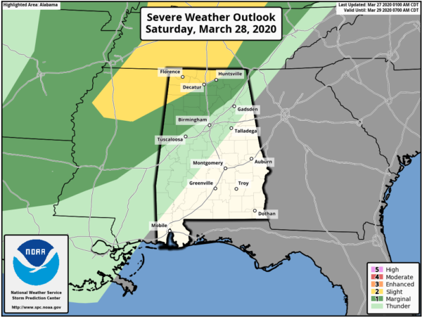
We do have the potential for strong to severe storms over the northwestern parts of the area during the late hours on Saturday through the pre-dawn hours on Sunday morning. A Slight Risk is up for locations north of a line from just north of Detroit (Lamar Co.) to Decatur (Morgan Co.) to New Market (Madison Co.). A Marginal Risk stretches to the south and east of that to as far south as just north of Geiger (Sumter Co.) to Kimberly (Jefferson Co.) to just east of Ider (Dekalb Co).
A moderate bit of instability will form during the heating of the day that may allow for the development of some scattered showers and thunderstorms during the afternoon and evening hours. A squall line will push through the area during the latter part of Saturday evening and through the overnight hours. There will be a decent amount of shear along with the instability that leads us to have the potential of some stronger to severe storms, with damaging winds and hail being the main threats. If the low-level shear is able to be a little stronger, then we’ll have to watch for the potential of a tornado or two in the threat locations.
Saturday’s highs look to be right back up into the mid-80s to just at or over 90 degrees across the area. Skies will be mostly clear to sunny to start, but clouds will begin to increase during the afternoon from the west and northwest.
Category: Alabama's Weather, ALL POSTS, Severe Weather
About the Author (Author Profile)
Scott Martin is an operational meteorologist, professional graphic artist, musician, husband, and father. Not only is Scott a member of the National Weather Association, but he is also the Central Alabama Chapter of the NWA president. Scott is also the co-founder of Racecast Weather, which provides forecasts for many racing series across the USA. He also supplies forecasts for the BassMaster Elite Series events including the BassMaster Classic.Subscribe
If you enjoyed this article, subscribe to receive more just like it.


