

Brief Update On Our Strong/Severe Storm Chances For Later Tonight Into Early Sunday
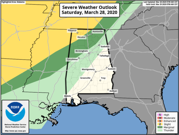
The latest Day 1 Severe Weather Outlook graphic from the Storm Prediction Center continues to show the northwest corner of North/Central Alabama in a Slight Risk for severe storms for later tonight and into the overnight hours. The Slight Risk includes locations north and west of a line from Hackleburg (Marion Co.) to Hillsboro (Lawrence Co.) to just north of Hazel Green (Madison Co.).
A Marginal Risk is up for locations to the south and east of the slight risk and stretches to a line from Geiger (Sumter Co.) to Kimberly (Jefferson Co.) to just northwest of Fort Payne (Dekalb Co.).
A weakening line of storms will be moving into the northwestern part of the state ahead of a cold front that will have the potential for a few stronger to severe storms with damaging winds up to 60 MPH and large hail up to one-inch in diameter being the main threats. A brief tornado or two cannot be ruled out, but they will not be likely.
Timing for the threat of severe storms in the risk locations will start tonight around 10:00 pm-11:00 pm in the extreme northwest and will progress across the area until the threat is expected to subside around 4:00 am Sunday. The line of rain and storms will continue to push eastward across the rest of the area, but the atmosphere should be more stable and severe weather will not be expected after 4:00 am.
We’ll have sufficient instability built up after the daytime heating, but that will be declining after the sun sets. While much of the forcing and dynamics will be well to our north, it may be just close enough that we’ll have to keep our eyes on the line as it moves into the area.
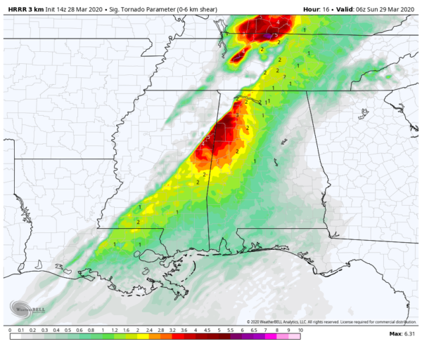
This is the latest Significant Tornado Parameter graphic from the latest run of the HRRR valid at 1:00 am and it shows values approaching 5.0 over portions of Marion and Lamar counties. This is just to show that we will have to watch these locations for the greater risk of a brief tornado or two.
This is not expected to be a big event for us, but if you are in the risk locations, go ahead and have everything ready just in case you go under a warning. Have multiple ways to receive warnings, especially ones that will wake you during the overnight hours. We’ll keep you posted throughout the day and through the event tonight. Have a great Saturday.
Category: Alabama's Weather, ALL POSTS, Severe Weather
About the Author (Author Profile)
Scott Martin is an operational meteorologist, professional graphic artist, musician, husband, and father. Not only is Scott a member of the National Weather Association, but he is also the Central Alabama Chapter of the NWA president. Scott is also the co-founder of Racecast Weather, which provides forecasts for many racing series across the USA. He also supplies forecasts for the BassMaster Elite Series events including the BassMaster Classic.Subscribe
If you enjoyed this article, subscribe to receive more just like it.


