Tornado Watch Issued Just To Our West & Northwest
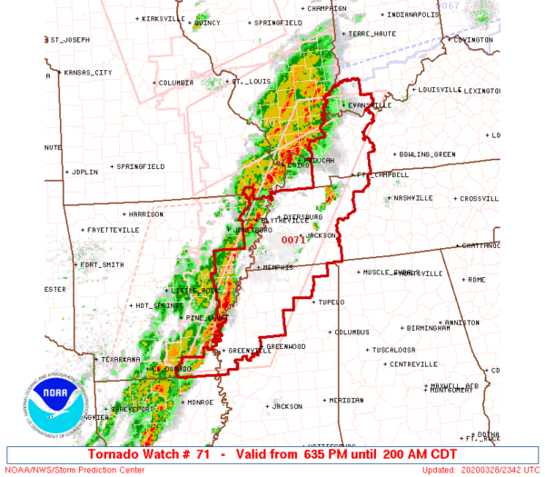
A line of strong to severe storms moving into the Deep South has prompted the Storm Prediction Center to issue a Tornado Watch for the following locations until 2:00 am CDT Sunday morning: far eastern Arkansas, far southwest Indiana, Western Kentucky, the Missouri Bootheel, Northwest Mississippi, and Western Tennessee.
Major damage occurred earlier from a large tornado that struck parts of Jonesboro, Arkansas. Here are a couple of Tweets of the tornado…
@spann @WeatherNation @TWCBreaking This is incredible from Jonesboro AR ?saidsaid pic.twitter.com/LNnHrsSE3X
— Dianna Lantz-Power ?? (@oumomof5) March 28, 2020
Jonesboro tornado… video from Matt Teal pic.twitter.com/cZqi21KtZa
— James Spann (@spann) March 28, 2020
Here is the text on the watch from the SPC:
Primary threats include…
A few tornadoes likely; a couple of intense tornadoes possible
Scattered damaging wind gusts to 70 mph likely
Isolated large hail up to 1.5 inches in diameter possible
Summary…
Extensive clusters of thunderstorms will evolve east-northeast tonight. Tornado risk through mid-evening will be greatest across the Kentucky and Tennessee portions of the watch, with an increasing risk towards late evening across Mississippi.
The tornado watch area is approximately along and 60 statute miles east and west of a line from 15 miles north of Evansville IN to 25 miles south of Greenville MS.
Remember…
A Tornado Watch means conditions are favorable for tornadoes and severe thunderstorms in and close to the watch area. Persons in these areas should be on the lookout for threatening weather conditions and listen for later statements and possible warnings.
Category: ALL POSTS, Severe Weather
About the Author (Author Profile)
Scott Martin is an operational meteorologist, professional graphic artist, musician, husband, and father. Not only is Scott a member of the National Weather Association, but he is also the Central Alabama Chapter of the NWA president. Scott is also the co-founder of Racecast Weather, which provides forecasts for many racing series across the USA. He also supplies forecasts for the BassMaster Elite Series events including the BassMaster Classic.Subscribe
If you enjoyed this article, subscribe to receive more just like it.


