

Mainly Dry Weekend; Active Pattern Through Much Of Next Week
MAINLY DRY FOR YOUR SATURDAY
We’ll start off the day with a surface low located over the northern parts of Louisiana with a cold front draping back into southern parts of Texas. That will send some clouds in our direction throughout the day and maybe a stray light shower or two late in the evening over the western portions of the area. Other than that, Saturday should remain dry and getting warm as highs will top out in the upper 70s to the lower 80s.
A SHOWER POSSIBLE FOR THE NORTH PARTS OF THE AREA ON SUNDAY
The cold front gets closer to the northwestern corner of the state to start off the day on Sunday which may bring a few stray showers over North Alabama and maybe creeping into the extreme northern parts of Central Alabama during the afternoon hours. Rain chance will be very small for those locations, while the rest of the area should stay dry with a mix of sun and clouds. Highs will be in the upper 70s to the lower 80s.
SCATTERED SHOWERS/STORMS POSSIBLE ON MONDAY
The cold front stalls out just to our northwest on Monday that will keep the atmosphere unstable enough for scattered showers and a few thunderstorms possible over the northern half of the area during the main heating of the day. Where there is no rain, skies will be partly to mostly clear. Highs will be in the lower to mid-80s across the area.
RAIN/STORMS LIKELY AT TIMES ON TUESDAY
The stalled cold front will actually wash out and dissipate over the northwestern parts of the area on Tuesday. That means we’ll have just enough energy necessary for rain and maybe a rumble of thunder or two to be likely at any time throughout much of the day. There will not be any instability in the area, so stronger to severe storms are not expected. Highs will be in the mid-70s to the lower 80s.
ACTIVE PATTERN CONTINUES ON WEDNESDAY
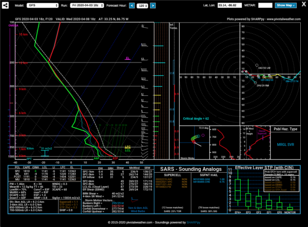
Another cold front will start to make its way toward and eventually into the northern parts of Central Alabama early on Wednesday. We will need to watch this system as the front passes through the area as there will be plenty of instability available to fuel thunderstorm formation and couple that with a decent bit of shear, we may have the potential of strong winds and small hail. This would not be a tornado setup as we will be lacking the helicity for rotating updrafts. The main window for the potential of stronger storms at this point will be from 1:00 pm to 1:00 am Thursday. Highs will be in the lower to mid-80s.
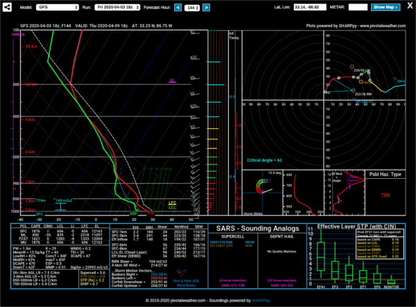
STRONG/SEVERE STORMS LOOK TO BE POSSIBLE ON THURSDAY
A strong surface low will be moving by just to our north during the latter part of the day on Thursday that may bring another round of stronger to severe storms to the area. We’ll have a good bit of instability over much of the area, and we’ll have enough shear and helicity that we may have to worry about a few rotating updrafts and the possibility of damaging winds and a brief tornado or two. Scattered storms will be possible early with the main line pushing through during the afternoon and into the evening hours. Rain should be out of the area by midnight. Afternoon highs will be in the upper 70s to the mid-80s.
DRY BUT BREEZY ON FRIDAY
As the low continues to push farther away from the area on Friday, those isobars will be closely packed on the backside which means winds will be quite breezy at times averaging 10-20 MPH out of the west-northwest. Clouds will finally give way to mainly clear skies by the afternoon hours and highs will top out in the lower 70s to the lower 80s.
BEACH FORECAST
Even though the beaches across the Alabama and Florida Gulf Coasts are closed, you may still want to know what the weather will be like. Get the latest weather and rip current forecasts for the beaches from Bay St. Louis, MS, to Panama City Beach, FL, on our Beach Forecast Center page. There, you can select the forecast of the region that you are interested in.
ADVERTISE ON THE BLOG!
We had another fantastic year in 2019 with just over 17 million page views! That brings our total for the last 2 years close to 37 million page views! Don’t miss out! We can customize a creative, flexible, and affordable package that will suit your organization’s needs. Contact Bill Murray at (205) 687-0782.
E-FORECAST
Get the Alabama Wx Weather Blog’s Seven-Day Forecast delivered directly to your inbox by email twice daily. It is the most detailed weather forecast available in Central Alabama. Subscribe here… It’s free!
CONNECT WITH THE BLOG ON SOCIAL MEDIA
You can find the AlabamaWx Weather Blog on the major social media networks:
Facebook
Twitter
Instagram
WEATHERBRAINS
Don’t forget you can listen to our weekly 90 minute netcast anytime on the web at WeatherBrains.com or on Apple Podcasts, Stitcher, or Spotify.
Category: Alabama's Weather, ALL POSTS, Severe Weather, Weather Xtreme Videos
About the Author (Author Profile)
Scott Martin is an operational meteorologist, professional graphic artist, musician, husband, and father. Not only is Scott a member of the National Weather Association, but he is also the Central Alabama Chapter of the NWA president. Scott is also the co-founder of Racecast Weather, which provides forecasts for many racing series across the USA. He also supplies forecasts for the BassMaster Elite Series events including the BassMaster Classic.Subscribe
If you enjoyed this article, subscribe to receive more just like it.


