

A Few Showers/Storms Today
WET AT TIMES: Today will be a mostly cloudy day across Alabama with potential for some rain at times; there might even be a strong thunderstorm this afternoon in spots. SPC maintains a low end, “marginal risk” (level 1/5) of severe thunderstorms for a part of West and Southwest Alabama later today.
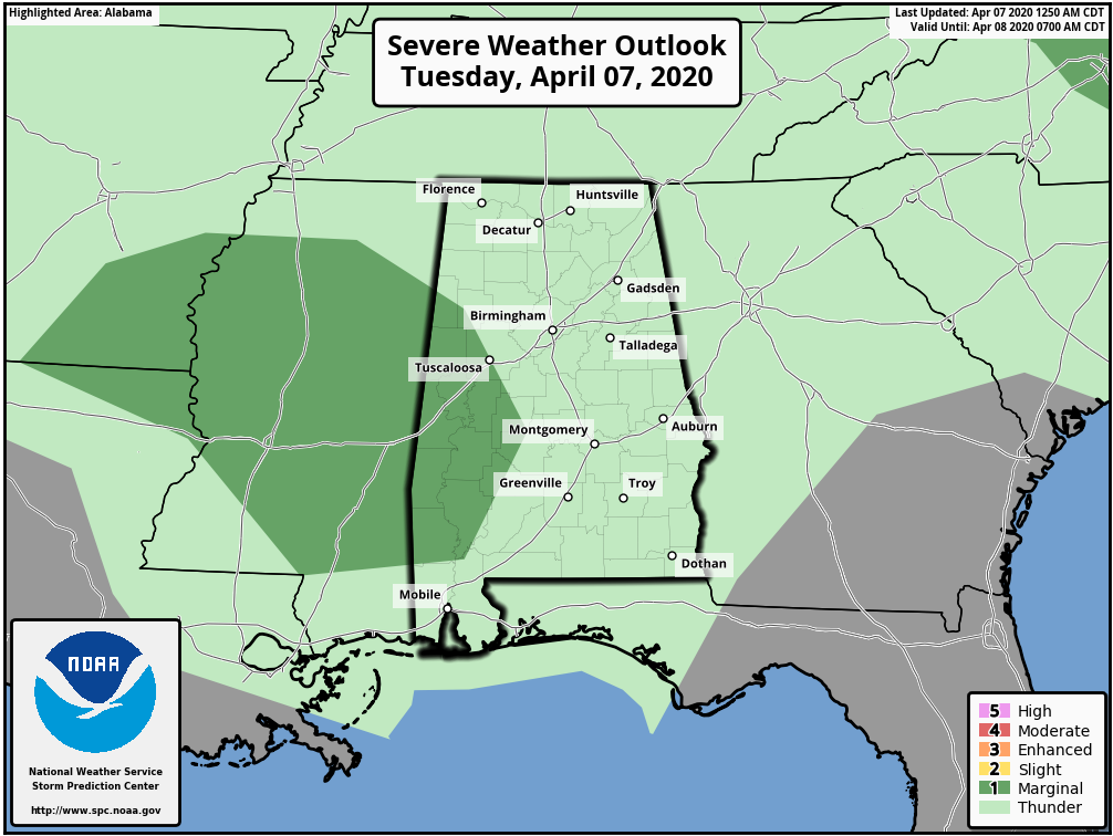
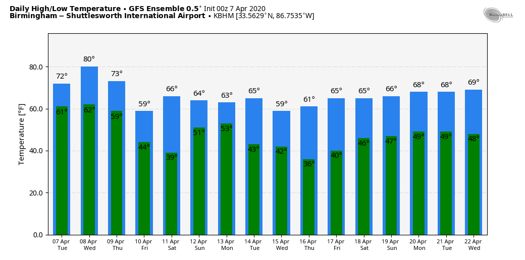
Heavier storms could produce small hail and gusty winds, but the overall threat is low. Look for a high in the mid to upper 70s today… the average high for April 7 at Birmingham is 72.
TOMORROW/THURSDAY: Tomorrow will be a warm day; we project a high in the 82-85 degree range with a mix of sun and clouds. The air becomes unstable, and a few scattered showers and storms are possible during the afternoon and evening hours, but much of the day will be dry. Then, late tomorrow night, a cold front will approach. This will bring a band of showers and strong storms into the state after midnight and into early Thursday morning. SPC has defined a “slight risk” (level 2/5) of severe storms for the Tennessee Valley of North Alabama, with a “marginal risk” down to Greensboro, Clanton, and Lafayette. Keep in mind this outlook runs through 7a CT Thursday.
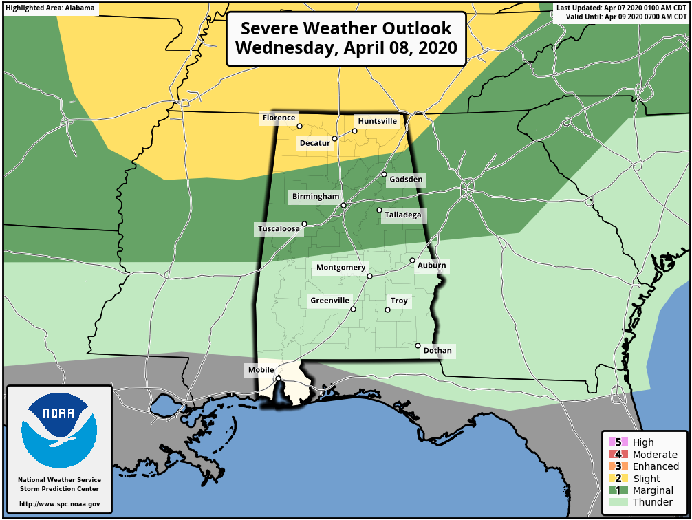
The main window for heavier thunderstorms will come from midnight tomorrow night through 6:00 a.m. Thursday. Main threats will come from hail and strong straight line winds; the tornado threat is very low, but not zero.
Then, during the day Thursday, the sky becomes partly to mostly sunny as dry air works into the state; the high will be close to 70 degrees.
FRIDAY/SATURDAY: Friday will be a sunny cool day with a high in the 60s. Colder pockets will drop into the 30s early Saturday morning with a chance of some scattered light frost; lows will range from 36 to 44 degrees. Saturday will be dry with a high in the upper 60s; clouds will begin to increase by afternoon ahead of a developing weather system to the west.
EASTER SUNDAY: We now have much better agreement with the global models; Sunday looks like an active weather day with potential for both strong thunderstorms and heavy rain. This could very well be a day with a risk of severe thunderstorms, but right now it is too early to call with questions concerning the thermodynamic environment. The high Sunday will be in the 70s, and rain amounts of 1-2 inches are likely.
NEXT WEEK: Much cooler air rolls into the state for the first half of the week; many North Alabama communities won’t get out of the 50s Monday, and we will have potential for another late season freeze or frost early Tuesday morning. See the Weather Xtreme video for maps, graphics, and more details.
ON THIS DATE IN 1926: Lightning started a disastrous oil fire at San Luis Obispo, California, which lasted for five days, spread over 900 acres, and burned over six million barrels of oil. Flames reached 1000 feet, and the temperature of the fire was estimated at 2,500 degrees. The fire spawned thousands of whirlwinds with hundreds the size of small tornadoes. One vortex traveled one mile to the east-northeast of the blaze, destroying a small farmhouse and killing two people. Damage totaled $15 million.
ON THIS DATE IN 1980: Severe thunderstorms spawned tornadoes that ripped through central Arkansas. The severe thunderstorms also produce high winds and baseball size hail. Five counties were declared disaster areas by President Carter. A tornado causing F3 damage also affected St. Louis and St. Charles counties in Missouri producing $2.5 million in damage.
ON THIS DATE IN 2006: Severe thunderstorms produced over a dozen tornadoes across Alabama, including EF-1 twisters at Gardendale and Roebuck.
BEACH FORECAST: Click here to see the AlabamaWx Beach Forecast Center page.
WEATHER BRAINS: Don’t forget you can listen to our weekly 90 minute show anytime on your favorite podcast app. This is the show all about weather featuring many familiar voices, including our meteorologists here at ABC 33/40.
CONNECT: You can find me on all of the major social networks…
Facebook
Twitter
Instagram
Pinterest
Snapchat: spannwx
Look for the next Weather Xtreme video here by 4:00 this afternoon… enjoy the day!
Category: Alabama's Weather, ALL POSTS, Weather Xtreme Videos
About the Author (Author Profile)
James Spann is one of the most recognized and trusted television meteorologists in the industry. He holds the AMS CCM designation and television seals from the AMS and NWA. He is a past winner of the Broadcast Meteorologist of the Year from both professional organizations.Subscribe
If you enjoyed this article, subscribe to receive more just like it.


