A Quiet Saturday Before A Dangerous Severe Weather Threat On Sunday
TODAY WILL BE THE QUIET BEFORE THE STORMS
After a chilly start across Central Alabama with temperatures starting off in the mid-30s to the lower 40s, we’ll have a very pleasant Saturday. Skies will be mostly clear during the daylight hours and afternoon highs will top out in the lower to mid-70s across the area. Clouds will be on the increase as we lose daylight and we’ll end up with mostly cloudy skies with showers and a few thunderstorms moving in around midnight. These thunderstorms will be elevated and the overall risk for severe weather is very low, but a strong storm is possible with small hail being the main threat. Lows bottom out in the 50s.
POTENTIALLY DANGEROUS SEVERE WEATHER EVENT ON EASTER SUNDAY
A strong surface low with an accompanying cold front will be approaching the area to start the day on Sunday while a warm front will be moving northward from the Gulf Coast and will eventually move completely across Central Alabama. As the warm front passes over and moves north of the area, the atmosphere will become highly unstable and primed for severe storms.
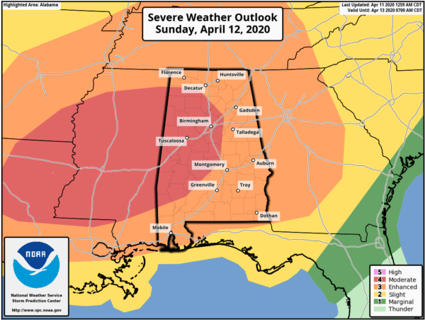
The Day 2 Severe Weather Outlook from the Storm Prediction Center released earlier at 1:00 am keeps a MODERATE RISK for severe storms (level 4 out of 5) for nearly all of the western half of the state and crossing over the I-65 corridor into the east-central parts. The rest of the state remains in an ENHANCED RISK for severe storms (level 3 of 5).
The latest run of the high-resolution NAM (00z) shows that there is the potential of surface-based instability values will be high, well over 1000 J/kg and nearly reaching 2000 J/kg by 10:00 pm. At the same time, shear will be maxing out up into the 60-80 knot range. Helicity values will be well more than sufficient for rotating storms, maxing out at over 600 m2/s2 in parts of the area. Lapse rates will also be rather steep, reaching nearly 7.0ºC/km. When combining all of those ingredients together, you will get a Significant Tornado Parameter with values reaching as high as 13.0 in the area.
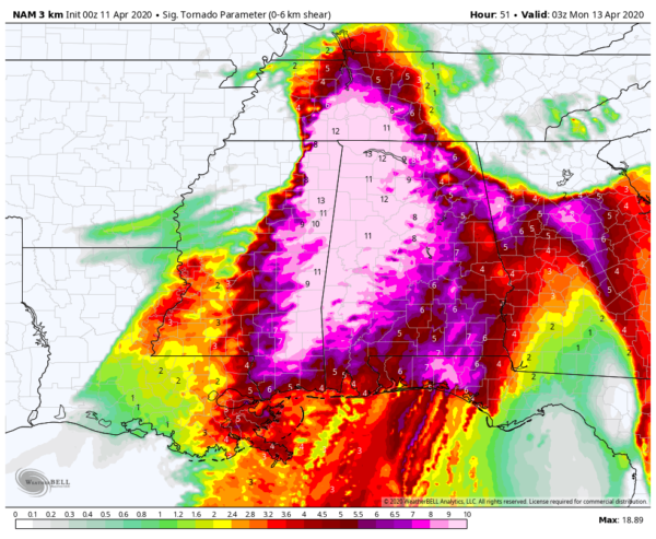
STP values valid Sunday at 10:00 pm.
With all of that said, we are looking for the potential of tornadoes, some of which may be stronger to violent long-track tornadoes, damaging winds up to and exceeding 70 MPH, and hail up to golf ball size in diameter. The 00z NAM sounding for the Birmingham metropolitan area shows the potential hazard as PDS Tornado, with the PDS standing for Particularly Dangerous Situation.
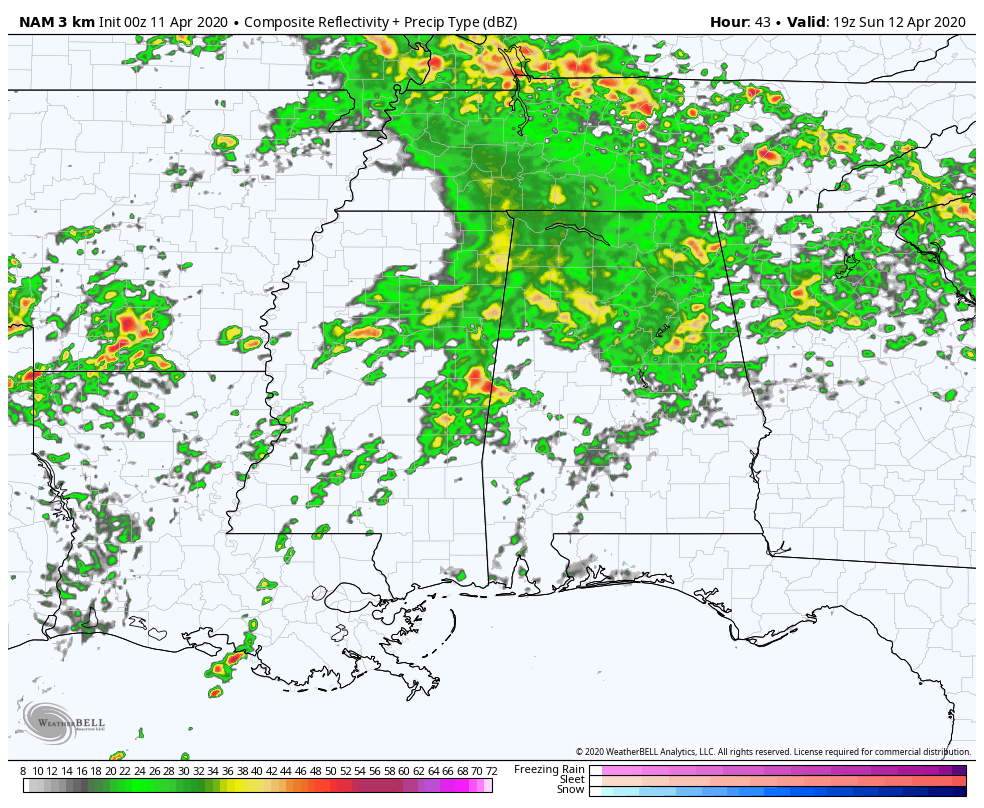
Timing of the threat of severe storms across the area will start around 2:00 pm on Easter Sunday and will continue through the rest of the day and will come to an end around Monday at 2:00 am. We’ll have multiple waves move through the area during that time, mostly in the form of supercellular structures before the main squall line pushes through later in the night and into the overnight hours. We’ll have to watch for any rogue storms that form out away from any clusters as these will be the ones with the potential of spawning the higher-end tornadoes.
All of these storms will be fast movers, so you will need to be alert to the weather throughout Easter Sunday, especially late into the day. Be prepared to act if a warning is issued for your location. You have a full day to make sure your severe weather safety kits are replenished and you have your plan of safety ready to act. Get that completed today because trying to do that on Sunday may be too late… especially with most places closing so that employees can spend time with their families. Turn on those WEAs, get fresh batteries in your Weather Radios, and download your favorite weather app that alerts you when your location goes under a warning. Have multiple ways of receiving warnings and do not rely on outdoor sirens.
A QUIET AND COOLER PATTERN THROUGH MUCH OF THE WEEK
By sunrise on Monday, we will have a stretch of very nice weather start for the entire workweek. Skies will start off with clouds moving out of the area and nearly maximum sunshine for the afternoon through sunset. Highs will range from the lower 60s in the northwestern parts of Central Alabama to near 80 degrees in the southeast. We may see some frost during the overnight hours in the northern parts of the area as lows will drop into the upper 30s to the upper 40s from north to south.
After a chilly start for your Tuesday, skies will remain mostly clear throughout the day. Some clouds will move in during the evening and late-night hours, but we look to stay dry at this point. Highs will be in the lower 60s to the mid-70s across the area from the northwest to the southeast.
Skies will become mostly sunny by the late morning hours on Wednesday and will stay that way through the remainder of the day. Highs will top out in the mid-60s to the lower 70s.
Thursday will be another dry day with a mix of sun and clouds. Highs topping out in the upper 60s to the lower 70s.
Mild temperatures return on Friday as we’ll continue to have a mix of sun and clouds. Highs will be in the 70s across the area, getting close to 80 degrees in the extreme southeastern parts of the area.
BEACH FORECAST
Even though the beaches across the Alabama and Florida Gulf Coasts are closed, you may still want to know what the weather will be like. Get the latest weather and rip current forecasts for the beaches from Bay St. Louis, MS, to Panama City Beach, FL, on our Beach Forecast Center page. There, you can select the forecast of the region that you are interested in.
ADVERTISE ON THE BLOG!
We had another fantastic year in 2019 with just over 17 million page views! That brings our total for the last 2 years close to 37 million page views! Don’t miss out! We can customize a creative, flexible, and affordable package that will suit your organization’s needs. Contact Bill Murray at (205) 687-0782.
E-FORECAST
Get the Alabama Wx Weather Blog’s Seven-Day Forecast delivered directly to your inbox by email twice daily. It is the most detailed weather forecast available in Central Alabama. Subscribe here… It’s free!
CONNECT WITH THE BLOG ON SOCIAL MEDIA
You can find the AlabamaWx Weather Blog on the major social media networks:
Facebook
Twitter
Instagram
WEATHERBRAINS
Don’t forget you can listen to our weekly 90 minute netcast anytime on the web at WeatherBrains.com or on Apple Podcasts, Stitcher, or Spotify.
Category: Alabama's Weather, ALL POSTS, Severe Weather, Weather Xtreme Videos
About the Author (Author Profile)
Scott Martin is an operational meteorologist, professional graphic artist, musician, husband, and father. Not only is Scott a member of the National Weather Association, but he is also the Central Alabama Chapter of the NWA president. Scott is also the co-founder of Racecast Weather, which provides forecasts for many racing series across the USA. He also supplies forecasts for the BassMaster Elite Series events including the BassMaster Classic.Subscribe
If you enjoyed this article, subscribe to receive more just like it.


