Saturday Afternoon Update
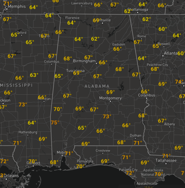
SPLENDID SPRING SATURDAY: WOW, it was a chilly, even frosty start to the day in many locations, but now that we are into the afternoon hours, it is oh so nice. We are seeing ample sunshine and temperatures in the 60s heading towards the 70s this afternoon and it is very comfortable with a dry air mass in place.
However, big changes occur in the atmosphere the next 24 hours, causing a very unstable and volatile atmosphere to develop over Alabama, which will lead to a severe weather outbreak for our Sunday. Today, is the calm before the storm, and the perfect time to prepare for what tomorrow holds as an outbreak of severe storms appears likely.
CALL TO ACTION: Now is the time to make sure you have all aspects of your severe weather plan ready for action and discuss it with all family members. Be sure you have multiple ways of receiving and hearing warnings. NEVER rely on an outdoor siren. Every home in Alabama should have a NOAA Weather Radio…be sure you have one in your home, properly programmed, and with fresh batteries. On your phone be sure WEA (Wireless Emergency Alerts) are enabled in your settings (under notifications). And, get the free ABC 33/40 Weather app, which does an excellent job of pushing warnings to you if you are in the polygon.
Determine and know your safe place. In a site built home, it is a small room (closet, bathroom, closet) on the lowest floor, near the center of the house, and away from windows. You do not have to be underground. In that safe place, have helmets for everyone, along with portable airhorns (if you are injured and need to alert first responders), and hard sole shoes (if you have to walk over a tornado debris field).
If you live in a mobile home, you cannot stay there during a tornado warning polygon. Know the location of the closest shelter or safe place, and know how to get there quickly. Check with your local county EMA (Emergency Management Agency) concerning shelter locations if you need help.
TO OUR WEST TODAY: We are watching the southern Plains as the storm system moves out of the Desert Southwest today, and will be causing severe weather across Texas and Oklahoma today where the level 3/5 “enhanced risk” is in effect.
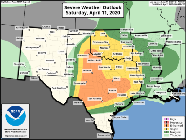
We are watching to see how the event unfold to our west and that could at least give us a glimpse into how tomorrow could go for us…
THINGS START TO CHANGE: Tonight, in response to an upper-level feature working across the state, our flow begins to switch out of the south, which will begin to return moisture across the state, and will allow for some showers to develop after midnight tonight and into the morning hours tomorrow. There could even be a few rumbles of thunder at times, but nothing severe with this activity being fairly elevated. Lows tonight, should be close to midnight, probably low to mid 50s, but after midnight, dew points will begin to increase, so temps will increase as well.
SUNDAY SEVERE WEATHER OUTBREAK: First, a reminder, we are in the middle of April, which is the heart of our spring severe weather season in Alabama. Severe weather is not unusual for this time of year, and for the most part, is expected with any storm system this time of year. No two events are a like, and every threat for severe weather in Alabama should always be taken seriously. For tomorrow, the overall scope and magnitude of the event, with the potential for a high impact, significant severe weather outbreak, is why we are pleading with people to be prepared and weather aware. We have been through these before, and we will go through them again, but now is the time to plan and be prepared for this likely severe weather outbreak.
THE SETUP: A very dynamic storm system will begin to track east across the country….an intensifying surface low, supported by ample upper-level dynamics, thanks to a negatively tilting upper-trough, will cause a warm front to lift rapidly north tomorrow, bringing a very unstable air mass into the state as surface dew points will surge into the 60s and 70s across Alabama. In the mid-levels, dry air coming off the Mexican Plateau will allow for greater lapse rates as well, adding an increased amount of instability. Winds fields at all levels of the atmosphere will be varying speeds and directions adding shear and helicity to the atmosphere. So again, you may be outside today, saying it doesn’t feel like severe weather, that will change the next 24 hours as all the players come together changing the atmospheric environment over the state.
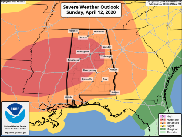
RISK ZONES: We want to make it clear, do not focus on risk zones, categories, or colors on the map, all of Alabama, all 67 counties, are under a significant threat for severe weather tomorrow, so don’t think because you are not in a higher risk category you won’t see severe weather, we are all under a significant threat. In the latest day 2 convective outlook just released this afternoon, the SPC maintains a” Moderate Risk” (level 4/5) for severe storms for much of Mississippi and Alabama with an “Enhanced Risk” (level 3/5) for the rest of Alabama on Sunday. The moderate risk has actually been expanded a bit farther east across Alabama.
Will this change or could it be upgraded? Yes, but again, don’t waste your time on that, severe weather is likely across all of Alabama tomorrow. The first convective day 1 convective outlook for tomorrow, will come out late tonight, with an update between 7 and 8am tomorrow morning.
THREATS: All modes of severe weather will occur tomorrow and that includes large hail, up to golf ball size, damaging winds up to 70 mph, and tornadoes. Some strong/violent EF2+, long-tracked tornadoes are probable. Additionally, heavy rainfall will occur tomorrow, and the heaviest rain will fall over the northern quarter of the state, communities across the Tennessee Valley could see 2-3 inches of rain with some flooding potential. Amounts will be lighter to the south across Central Alabama (1-2 inches).
TIMING: I believe we will likely see multiple rounds of severe storms tomorrow, perhaps three rounds with the severe threat starting around midday 12PM-1PM, lasting through the afternoon, evening, and overnight hours, till about 3AM. So 12PM Sunday afternoon through 3AM Monday morning. First thing tomorrow morning, we are very likely to have rain and a few storms ongoing across the area, again nothing severe.
ROUND 1: Tomorrow morning, the warm front will be along the Gulf Coast, it will begin to rapidly head north across the state in response to the approaching storm system. As it does, rain and storms are likely to develop along it and some of these could be strong and possibly severe, but should remain elevated, so hail and damaging winds are possible. If any of these can become surface based, the shear along the actual front could cause these to rotate and pose a brief, tornado threat. Not likely, but I have seen this happen several times, so we will be watching. The warm front should begin pushing out of North Alabama by early afternoon. Ending this initial threat.
ROUND 2: Behind the warm front, rain and storms will come to an end, and we are likely to see some clearing, allowing temperatures to surge well into the 70s and 80s across the state. The low-level jet will be howling out of the south, and surface winds will be out of the southeast at 15-30 mph, with higher gusts, transporting the moisture-rich air mass north. The heating of the day, will allow for instability values to surge in the 1500-2000 J/kg range, as a capping inversion in the mid-levels due to the dry air off the Mexican Plateau will prevent convection from developing. The wind field over the state by this time will be highly sheared, and as instability continues to build, the cap could erode away, which would allow for isolated convection to develop. With such a volatile atmosphere in place, these storms, if they develop, will have to be watched closely as they are likely to become strong or severe quickly due to the environment in place. This is likely to occur by mid-afternoon, and these will be well out ahead of the main line, and these will be particularly dangerous, as they will likely to become tornadic and race rapidly off to the northeast. These will be our main concern from mid-afternoon through the evening hours.
ROUND 3: This will be the line of storms that will develop along the dry line, yes the dry line, which usually remains in the western Plains. On occasion it makes it this far east, usually with severe weather events and will cause the last and final round of severe storms to develop tomorrow late afternoon/evening. This QLCS or line of storms, which looks to be a broken line of rotating supercells, will move across Mississippi tomorrow evening, and push into and across Alabama during the overnight hours, 8PM-3AM. These are likely going to be severe, as the environment will remain unstable and highly sheared, will also pose a tornado threat, along with damaging winds and hail. Once the feature passes your location, the severe weather threat will come to an end.
Will the forecast change? Absolutely, over the next 24 hours things will be changing, and there is always some uncertainty when it comes to thunderstorms and severe weather events in the Alabama. Yes, we have a high confidence in this event due to the large, synoptic scale setup, but the true overall scope, magnitude, and impact will be determined by the small scale features and boundary interactions that a lot of times can only be known within a few hours of the event.
Again, today is a day to prepare and be ready. Have the severe weather plan ready to be implemented, have multiple ways to receive warnings, and stay weather aware. We are going to see watches and warnings tomorrow, just make sure you can get them and be ready to act. Check the blog frequently for updates as well.
Some additional notes…The first storm of the day will tell a lot about the day unfolds. During the afternoon, if the isolated storms develop and rapidly become severe and/or tornadic, it is fair assessment that other storms through the day could do the same.
Hopefully we will have no tornadoes or severe weather tomorrow. We could have numerous tornadoes tomorrow or none, but that doesn’t matter, the threat is there. It only takes one tornado to make this a bad very day for the state. So be smart and be ready.
Each event is different, and it is unwise to think it won’t happen to me because it has never happened to me; or compare each threat to past events such as April 27, 2011. If there is only one tornado in the entire state tomorrow, and if that one hits your home, then that is YOUR April 27. There is a good chance we see more than one tornado tomorrow in Alabama.
COVID 19: The decision to seek shelter in a community storm shelter is certainly made more difficult by the consideration for COVID-19, and each individual will need to make an educated decision on where and when to shelter from a tornado. At this time, the Alabama Department of Public Health (ADPH) is recommending that your first priority should be to protect yourself from a potential tornado. If a warning is issued for your area, you are more likely to be affected by the tornado than the virus.
However, the decisions to open any community shelters are done at the local or county level. Before you make a decision to go to a community shelter, you should check with your community shelter managers to ensure they are open, and if there are any local COVID-19 considerations. Certainly, wherever you choose to shelter from a tornado, you should use as many precautions as possible to inhibit the spread of COVID-19 as best as you can. If you rely on public community shelters, now is the time to explore other options that might keep you safer from severe weather and possibly limit your exposure to COVID-19.
NEXT WEEK: Behind the Sunday system, and ridge of high pressure will build in across Alabama, ending the rain and storm threat, and bring a quieter weather pattern to the state for much of the week ahead. Each day should feature more sun than clouds with highs in the 60s and 70s. Nights will be chilly early in the week with 30s and 40s..growers beware, the could be a potential for another late season freeze or frost early Tuesday morning. The rest of the week, nighttime temps will be moderating. We still need to mention a few stray showers are possible Tuesday night and Wednesday, but there should be across southern portions of the state, and for the most part, much of the week is looking dry.
BEACH FORECAST CENTER: Get the latest weather and rip current forecasts for the beaches from Fort Morgan to Panama City on our Beach Forecast Center page. There, you can select the forecast of the region that you are interested in visiting.
WORLD TEMPERATURE EXTREMES: Over the last 24 hours, the highest observation outside the U.S. was 114.1F at Diourbei, Senegal. The lowest observation was -91.3F at Concordia, Antarctica.
CONTIGUOUS TEMPERATURE EXTREMES: Over the last 24 hours, the highest observation was 97F at Rio Grande Village, TX. The lowest observation was 18F at Polebridge, MT.
WEATHER ON THIS DATE IN 1965: Severe thunderstorms in the Upper Midwest spawned fifty-one tornadoes killing 256 persons and causing more than 200 million dollars damage. Indiana, Ohio and Michigan were hardest hit in the “Palm Sunday Tornado Outbreak”.
Category: Alabama's Weather, ALL POSTS
About the Author (Author Profile)
Macon, Georgia Television Chief Meteorologist, Birmingham native, and long time Contributor on AlabamaWX. Stormchaser. I did not choose Weather, it chose Me. College Football Fanatic. @Ryan_StinnetSubscribe
If you enjoyed this article, subscribe to receive more just like it.


