A Late Night Look At Easter Sunday’s Potential For Dangerous Severe Weather
As of right before midnight on Saturday night, we continue to see the potential for strong to violent, long-track tornadoes, damaging straight-line winds up to and exceeding 70 MPH, and severe hail up to golf ball size in diameter across all of North/Central Alabama throughout much of the second half of your Easter Sunday and into the pre-dawn hours on Monday.
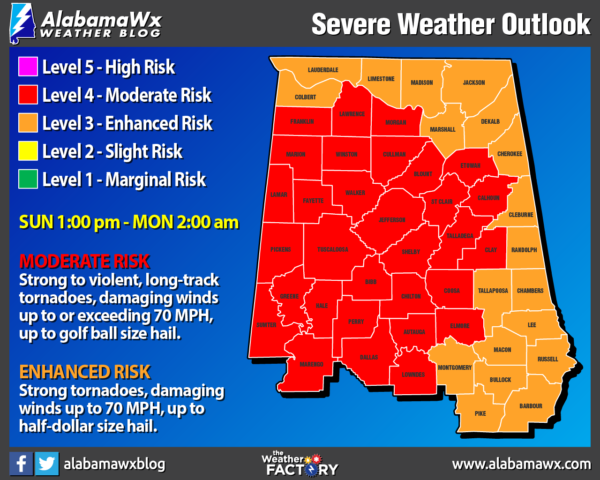
A MODERATE RISK (level 4 of 5) covers much of the western three-quarters of North/Central Alabama while an ENHANCED RISK (level 3 of 5) continues for the extreme northern and western parts of the area.
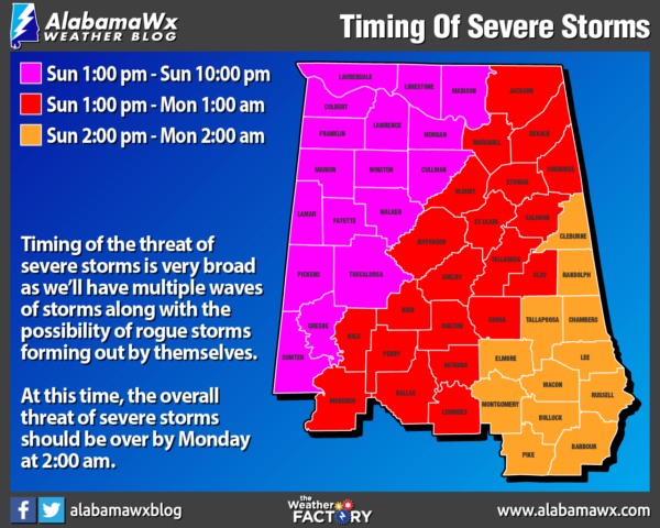
Timing for severe storms will be broad across the area and will be hard to nail down exactly as there will be several waves or clusters of storms before the main squall line associated with the cold front moves through during the late-night hours and into the overnight hours. We’ll also have to watch for discrete supercells to form outside of the clusters. At this time, we are looking at the window for severe storms starting Sunday at 1:00 pm and coming to an end Monday around 2:00 am.
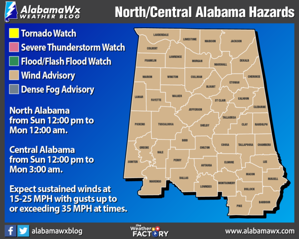
With the stronger pressure gradient, a Wind Advisory has been issued for all of Central Alabama from Sunday at 12:00 pm through Monday at 3:00 am and for all of North Alabama from Sunday at 12:00 pm through Monday at 12:00 am. Winds outside of the storms are expected to be sustained at 15-25 MPH with gusts up to and exceeding 35 MPH possible at times.
Storms will be fast-moving so take cover immediately if your location goes under a tornado or severe thunderstorm warning. Also, with the possibility of rogue discrete supercells forming during the afternoon, you will need to stay weather aware throughout the entire day.
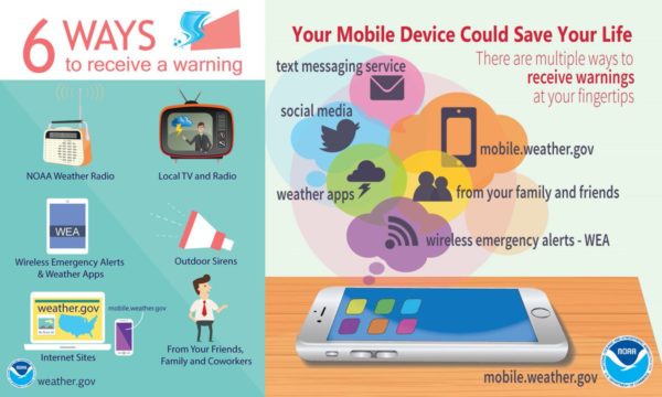
Have multiple ways to receive warnings, including the WEAs installed on your smartphones. Do not rely just on tornado sirens as they can be unreliable. Have your favorite news channel app downloaded so you can watch live tornado coverage when/if in your place of safety. Emergency kits and plans of action need to be ready now. Know where to go if you go under a warning polygon.
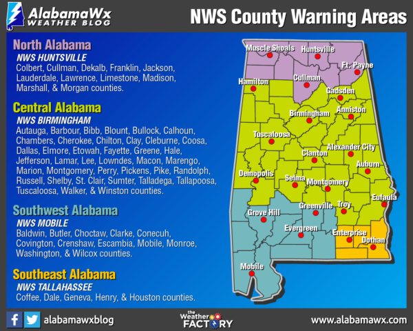
Just as a quick reminder, here is the list of counties that are served by your local National Weather Service forecast offices:
NWS Huntsville
Colbert, Cullman, DeKalb, Franklin, Jackson, Lauderdale, Lawrence, Limestone, Madison, Marshall, and Morgan counties.
NWS Birmingham
Autauga, Barbour, Bibb, Blount, Bullock, Calhoun, Chambers, Cherokee, Chilton, Clay, Cleburne, Coosa, Dallas, Elmore, Etowah, Fayette, Greene, Hale, Jefferson, Lamar, Lee, Lowndes, Macon, Marengo, Marion, Montgomery, Perry, Pickens, Pike, Randolph, Russell, Shelby, St. Clair, Sumter, Talladega, Tallapoosa, Tuscaloosa, Walker, and Winston counties.
Category: Alabama's Weather, ALL POSTS, Severe Weather
About the Author (Author Profile)
Scott Martin is an operational meteorologist, professional graphic artist, musician, husband, and father. Not only is Scott a member of the National Weather Association, but he is also the Central Alabama Chapter of the NWA president. Scott is also the co-founder of Racecast Weather, which provides forecasts for many racing series across the USA. He also supplies forecasts for the BassMaster Elite Series events including the BassMaster Classic.Subscribe
If you enjoyed this article, subscribe to receive more just like it.


