

CANCELED – Severe T-Storm Warning: Dallas County Until 10:45 PM
The National Weather Service in Birmingham has issued a
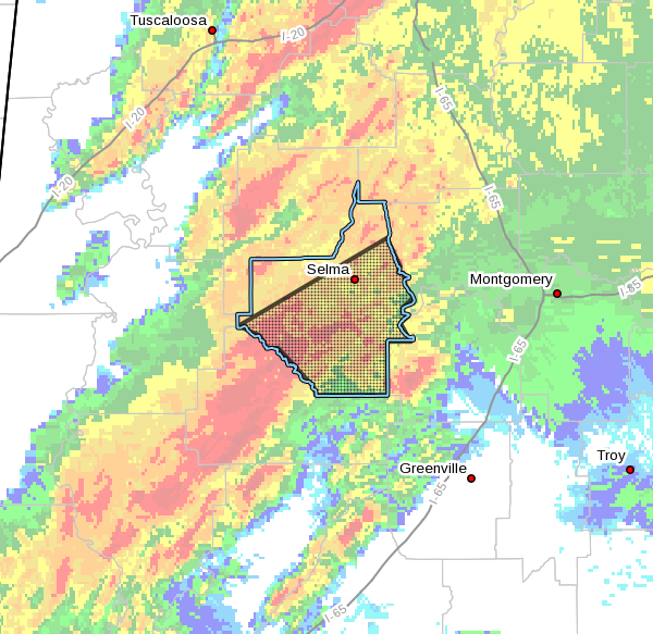
* Severe Thunderstorm Warning for…
Dallas County in south central Alabama…
* Until 1045 PM CDT.
* At 1001 PM CDT, a severe thunderstorm was located 7 miles southeast
of Central Mills, or 15 miles north of Camden, moving northeast at
55 mph.
HAZARD…60 mph wind gusts and penny size hail.
SOURCE…Radar indicated.
IMPACT…Expect damage to roofs, siding, and trees.
* Locations impacted include…
Selma, Selmont-West Selmont, Orrville, Gardner Island, Tyler, Old
Cahaba Park, Dannelly Reservoir, Dallas County Horse Arena,
Belknap, Dallas Lake, Memorial Stadium, Burnsville, Potter Station,
Carlowville, Safford, Hazen, Minter, Craig Field Aiport, Selma Drag
Strip and Skyharbor Airport.
PRECAUTIONARY/PREPAREDNESS ACTIONS…
A Tornado Watch remains in effect until midnight CDT for central and
south central Alabama.
For your protection move to an interior room on the lowest floor of a
building.
Category: Alabama's Weather, ALL POSTS, Severe Weather
About the Author (Author Profile)
Scott Martin is an operational meteorologist, professional graphic artist, musician, husband, and father. Not only is Scott a member of the National Weather Association, but he is also the Central Alabama Chapter of the NWA president. Scott is also the co-founder of Racecast Weather, which provides forecasts for many racing series across the USA. He also supplies forecasts for the BassMaster Elite Series events including the BassMaster Classic.Subscribe
If you enjoyed this article, subscribe to receive more just like it.


