Tornado Risk Continues And New Watch To Be Issued Soon
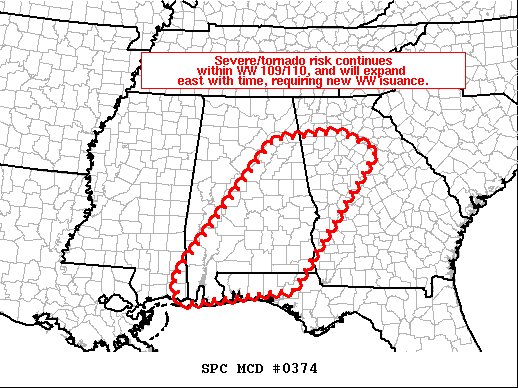
Areas affected…parts of Alabama and into western and central
Georgia and portions of the Florida Panhandle
The severe weather threat for Tornado Watch 110 continues.
SUMMARY…Severe/tornado risk continues across WW 109 and 110, and
will spread eastward into western and central Georgia and parts of
the Florida panhandle over the next few hours.
DISCUSSION…Latest radar loop shows convection now occurring in a
complex/broken band from the southern Appalachians
south-southwestward to near Mobile Bay. Within this band, several
well-organized clusters of storms — including numerous rotating
updrafts and comma heads — are indicated. Mixed-layer CAPE of 1000
to 1500 J/kg is indicated across this region, and extreme low-level
shear is observed (0-1km shear 40 to 50 kt and 0-1km storm-relative
helicity in excess of 700 m2/s2 across GA).
Given the environment, tornado risk remains high with stronger
clusters embedded within the main convective band, and with any
cells which may develop in advance of the line. A new tornado watch
will be issued shortly across southern and eastern Alabama, and into
Georgia and the Florida Panhandle.
Category: Alabama's Weather, ALL POSTS, Severe Weather
About the Author (Author Profile)
Scott Martin is an operational meteorologist, professional graphic artist, musician, husband, and father. Not only is Scott a member of the National Weather Association, but he is also the Central Alabama Chapter of the NWA president. Scott is also the co-founder of Racecast Weather, which provides forecasts for many racing series across the USA. He also supplies forecasts for the BassMaster Elite Series events including the BassMaster Classic.Subscribe
If you enjoyed this article, subscribe to receive more just like it.


