EXPIRED – Severe Thunderstorm Warning for Parts of Calhoun, Cherokee, Cleburne, and Etowah Counties till 11:45 PM CDT
THE NATIONAL WEATHER SERVICE IN BIRMINGHAM HAS ISSUED A
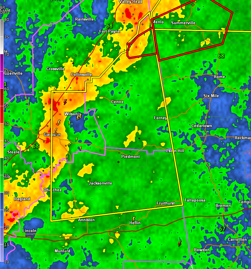
* SEVERE THUNDERSTORM WARNING FOR…
CALHOUN COUNTY IN EAST CENTRAL ALABAMA…
EASTERN ETOWAH COUNTY IN NORTHEASTERN ALABAMA…
NORTHEASTERN CLEBURNE COUNTY IN EAST CENTRAL ALABAMA…
CHEROKEE COUNTY IN NORTHEASTERN ALABAMA…
* UNTIL 1145 PM CDT.
* AT 1047 PM CDT, SEVERE THUNDERSTORMS WERE LOCATED ALONG A LINE
EXTENDING FROM NEAR SAND ROCK TO NEAR WEAVER, MOVING NORTHEAST AT
85 MPH.
HAZARD…60 MPH WIND GUSTS.
SOURCE…RADAR INDICATED.
IMPACT…EXPECT DAMAGE TO ROOFS, SIDING, AND TREES.
* LOCATIONS IMPACTED INCLUDE…
GADSDEN, ANNISTON, JACKSONVILLE, PIEDMONT, HOKES BLUFF, CENTRE,
CEDAR BLUFF, LITTLE RIVER CANYON NATIONAL PRESERVE, FORNEY, CENTRE
MUNICIPAL AIRPORT, FORT MCCLELLAN, SAKS, WEST END-COBB TOWN,
GLENCOE, WEAVER, OHATCHEE, LEESBURG, REECE CITY, SAND ROCK AND
FRUITHURST.
Category: Alabama's Weather, ALL POSTS, Severe Weather
About the Author (Author Profile)
Bill Murray is the President of The Weather Factory. He is the site's official weather historian and a weekend forecaster. He also anchors the site's severe weather coverage. Bill Murray is the proud holder of National Weather Association Digital Seal #0001 @wxhistorianSubscribe
If you enjoyed this article, subscribe to receive more just like it.


