Improving Conditions Today; Strong to Severe Storms On Sunday
IMPROVING WEATHER TODAY
A cold front will continue to push through the area during the morning hours and will eventually stall out along the Gulf Coast later today. The shower activity out there now will come to an end before midday and we’ll be left with a decent afternoon and early evening with skies becoming mostly clear over the northern half of the area to partly cloudy in the south. Afternoon highs look to top out in the lower 70s to the lower 80s.
STRONG TO SEVERE STORMS ON SUNDAY
The cold front will be pulling back north through the area as a warm front during the first part of the day on Sunday ahead of a shortwave along with a strong surface low that will eventually move into and across Central Alabama during the evening and late-night hours. We’ll have a morning round of rain and thunderstorms move through the area along and north of the warm front, but once the front passes your location, rain should mostly come to an end for a little while. While there is this break in the rain, it will allow the atmosphere to recover and really become unstable during the heating of the day. Storms are likely to form in Mississippi and move into the area which has the potential to become severe especially over the southern half of North/Central Alabama during the late afternoon and through the rest of the day and into the overnight hours. Highs should reach the mid to upper 70s for most across Central Alabama.
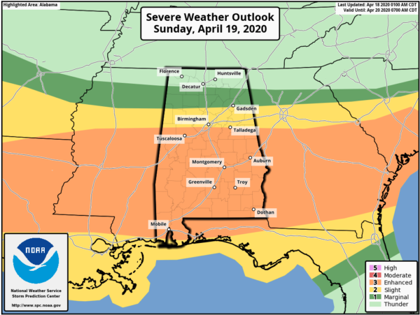
SPC has an Enhanced Risk up for the southern two-thirds of Central Alabama on Sunday through the pre-dawn hours on Monday, which is a level 3 out of 5. This includes everyone located along and south of a line from Reform (Pickens Co.) to Homewood (Jefferson Co.) to just north of Woodland (Randolph Co.). A Slight Risk is up for locations above that to as far north as Guin (Marion Co.) to Oneonta (Blount Co.) to Pleasant Gap (Cleburne Co.). A Marginal Risk is up for locations as far north as Russellville (Franklin Co.) to Priceville (Morgan Co.) to Fort Payne (Dekalb Co.).
The latest high-resolution NAM shows a boundary potentially forming just south of the I-20 corridor where the highest levels of instability will be located during the afternoon and evening hours. Helicity values will be highest over the same general area as well, but all of North/Central Alabama will have a good bit of wind shear. This agrees with the SPC risks that will keep the majority of severe storms along and south of I-20.
While much of this has some of the same looks as the Easter Sunday outbreak of just one week ago, this looks to be a weaker system and will be a little further south, but that doesn’t mean we need to let our guard down as it has the potential to be a significant severe weather event.
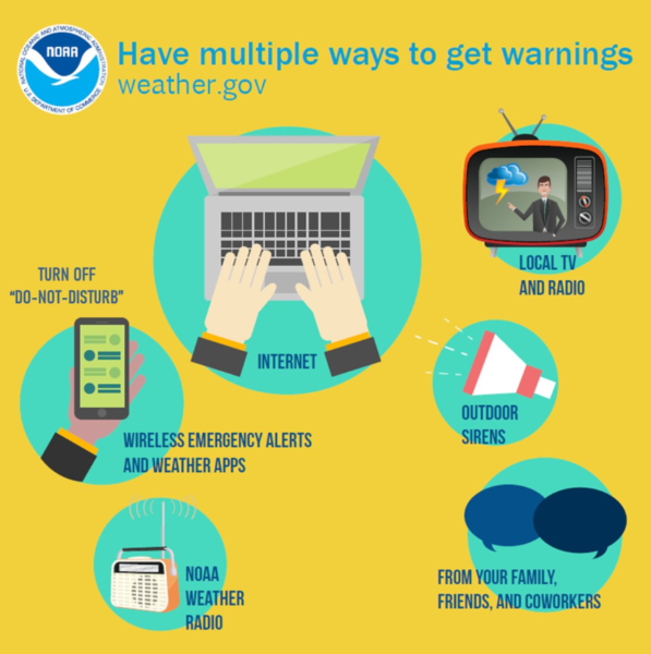
You know the drill… Have your emergency kits fully packed, your safe place, and your severe weather action plan ready to go. We have a couple of days before the event, so you have time to prepare. Have multiple ways of receiving warnings. Do not rely just simply on outdoor sirens.
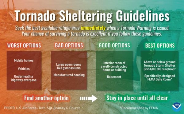
Do not attempt to ride out a tornado warning in a mobile/manufactured home or in a car. You have time to make plans to go to a more sturdy structure or a local tornado shelter. You do this, your chance of surviving a tornado is excellent, especially if you plan well ahead of the event and are ready to act if a warning is issued for your location.
A QUIET START TO NEXT WEEK
Quiet weather returns on Monday as we’ll have clearing skies and afternoon highs reaching the mid-70s to the lower 80s. Much of the same on Tuesday… plenty of sunshine and warmer. Afternoon highs will be in the upper 70s to the mid-80s.
STRONG TO SEVERE STORMS POSSIBLE LATE WEDNESDAY INTO EARLY THURSDAY
Another strong low will be heading in our direction and will begin ramping up across the Southern Plains on Wednesday. We’ll be in the warm and moist flow out ahead of that approaching low and cold front. Showers and storms look to move into the area during the late-night and through the overnight hours. This could be another severe weather maker for the area, but we’ll dive more into that system once we get through Sunday’s action. Highs will be in the upper 70s to the mid-80s.
Rain and storms will be exiting the area during the morning hours on Thursday, but we may continue to have a few lingering light showers to wrap around across portions of the area on the backside of the low. Highs will be in the lower 70s to the lower 80s.
NICE WEATHER TO END THE WORK WEEK
Friday looks to be a quiet day across Central Alabama. Skies look to be mostly sunny with highs reaching the upper 70s to the mid-80s
BEACH FORECAST
Even though the beaches across the Alabama and Florida Gulf Coasts are closed, you may still want to know what the weather will be like. Get the latest weather and rip current forecasts for the beaches from Bay St. Louis, MS, to Panama City Beach, FL, on our Beach Forecast Center page. There, you can select the forecast of the region that you are interested in.
ADVERTISE ON THE BLOG!
We had another fantastic year in 2019 with just over 17 million page views! That brings our total for the last 2 years close to 37 million page views! Don’t miss out! We can customize a creative, flexible, and affordable package that will suit your organization’s needs. Contact Bill Murray at (205) 687-0782.
E-FORECAST
Get the Alabama Wx Weather Blog’s Seven-Day Forecast delivered directly to your inbox by email twice daily. It is the most detailed weather forecast available in Central Alabama. Subscribe here… It’s free!
CONNECT WITH THE BLOG ON SOCIAL MEDIA
You can find the AlabamaWx Weather Blog on the major social media networks:
Facebook
Twitter
Instagram
WEATHERBRAINS
Don’t forget you can listen to our weekly 90 minute netcast anytime on the web at WeatherBrains.com or on Apple Podcasts, Stitcher, or Spotify.
Category: Alabama's Weather, ALL POSTS, Severe Weather, Weather Xtreme Videos
About the Author (Author Profile)
Scott Martin is an operational meteorologist, professional graphic artist, musician, husband, and father. Not only is Scott a member of the National Weather Association, but he is also the Central Alabama Chapter of the NWA president. Scott is also the co-founder of Racecast Weather, which provides forecasts for many racing series across the USA. He also supplies forecasts for the BassMaster Elite Series events including the BassMaster Classic.Subscribe
If you enjoyed this article, subscribe to receive more just like it.


