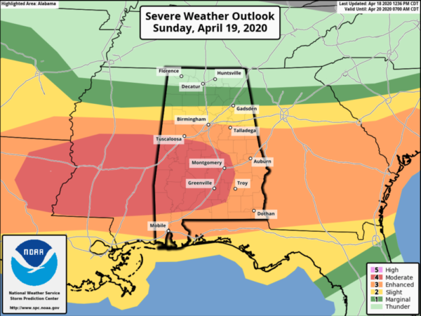
SPC Upgrades to Moderate Risk for Sunday
We had some showers early this morning as a weak cold front pushed south through the state, but as we roll into the afternoon hours, the weather is looking pretty good across much of Alabama.
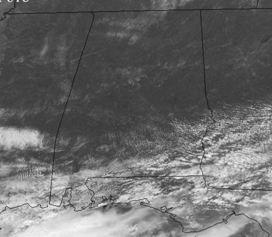
We are seeing more sunshine than clouds, with temps climbing towards the upper 60s and lower 70s. Clouds will again begin to increase overnight and shower return to the state and by first thing tomorrow morning we could see strong storms as a warm front begins to lift north across Alabama.
MORE SEVERE STORMS LIKELY SUNDAY: Another Sunday with very active weather for Alabama and again, this will be another threat with multiple rounds of strong and severe storms possible. This event will be different than last week, but it carries its own significant threats and the warm front will be the key player in this event, as the severe weather threat will only extend as far north as the front makes it. Along and south of the front is where the severe weather threat will be, but north of the front there will still be rain and storms, but again, the greatest severe weather threat looks to be confined to the southern two-thirds of Alabama.
PLACEMENT: Latest Day 2 Convective Outlook just out the SPC has upgraded to a “moderate risk” (level 4/5) across portions of Alabama, including areas of Central Alabama, just south of Tuscaloosa, but including areas around Clanton, Prattville, Wetumpka, Montgomery, Selma, Demopolis, Greenville, Jackson, Grove Hill, and Monroeville with an “enhanced risk” (level 3/5) for the rest of Alabama south of Interstate 20. A “slight risk” (level 2/5) is out for areas between I-20 and U.S. 278, with a with a “marginal risk” (level 1/5) extending as far north as the Tennessee River. Don’t focus on colors and lines on the maps, nearly all of Alabama is under a threat of severe weather.
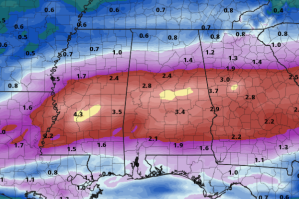
The front which came through the state early this morning, will start to lift back north as a warm front late tonight and through the day tomorrow as the developing low to the west pulls it north. Again, this front should make it as far north as North/Central Alabama by tomorrow afternoon, perhaps as far north as the Interstate 20, if not that far north, it should at least make it to the areas between Birmingham and Montgomery. Areas along south of that front is where the highest severe weather threat will be for tomorrow. South of the front, the southerly flow brings in warm/moist air into our area, increasing instability to 2000-3500 J/kg range across South Alabama, which would favor explosive development of storms during the afternoon hours, if they develop.
Again, it looks to be a day with multiple rounds of storms for the state, with round one early tomorrow morning associated with warm front slowly lifting north and these could develop as early as 3AM, lasting through the morning hours. These storms should be elevated, but will still be capable of producing large hail and damaging winds. Not much of a tornado threat with these, but if any storm can become surface based, there could be a tornado or two, this threat looks to be across Southeast Alabama late in the morning, but the main tornado threat comes later in the day.
We should get a lull in the action by late morning and into the afternoon, and by then, we should see a thermal gradient in place across Alabama, which will help determine the northward extent of the severe weather threat for the rest of the day. During this lull, the warm front should continue to slowly move north, allowing the atmosphere to prime itself over the southern portions of the state. By early afternoon, we could begin to see the development of storms, and with such a volatile atmosphere in place, they could develop quickly and become severe and these are likely to be those individual supercells which will be rotating, increasing the tornado threat, but still capable of producing damaging winds and large hail. It is not out of the question to see several strong tornadoes (EF2 or higher), occur especially over the southern half of the state in the “moderate risk”, but again, the tornado threat is fo much of Alabama.
Finally, by late afternoon and into the evening hours, we should see a large cluster of storms develop to the west, and this will begin to track east along the warm front. As it does, it will likely be producing damaging winds up to 70 mph, large hail, and yes some tornadoes are possible. If any storms develop out ahead of this cluster, these will once again be those individual supercells which will need to be monitored closely. Along with the severe weather threat with this cluster of storms, flooding will be a major concern as they will be producing intense rainfall, and with rain at times early in the day, it will not take much to see flash flooding develop.
FLASH FLOODING: Along with severe storms, we are likely to see flash flooding develop across Alabama with rainfall totals easily in the 2-4” range with isolated higher amounts.
For this reason, a FLASH FLOOD WATCH has been issued for Sunday for all of Central Alabama, roughly along and south of the Interstate 20 corridor, including the cities of Tuscaloosa and Birmingham. Again stay weather aware Sunday, and be prepared to act and to always TURN AROUND, DON’T DROWN if you come across flood waters.
The severe weather threat will be winding down from west to east during the overnight hours, and I think by midnight, the severe weather threat will be over. Again, the northward extent of the warm front will determine the severe weather threat across Alabama. For much of North Alabama tomorrow, tomorrow will be a wet and stormy day, but severe weather is not as much of a concern, but still flooding could be an issue. Along and south of the warm front, where that may develop tomorrow, there will be a significant threat for severe weather tomorrow with all modes of severe weather likely including strong tornadoes, damaging winds, and large hail.
With any severe weather system, a lot will be determined by the small scale features which set-up the day of the event. This is April in Alabama, the heart of our severe weather season, so this is not unusual and we are use to severe weather threat this time of year. We have been through events like this before, we will go through them again, and we will make it through this one together. Just be prepared and ready to act. Hopefully, we can make it through tomorrow with no major problems. No two events are the same, so don’t think this event will happen just like last weekend. This event is completely different, but it carries its own significant threat and everyone will need to be prepared. It only takes one storm to makes this a very bad day for the state.
CALL TO ACTION: Today is time to prepare and to make sure you have all aspects of your severe weather safety plan ready for action. Be sure you have a way of hearing severe weather warnings, and an action plan if you are in a tornado warning polygon, but also, take severe thunderstorm warnings seriously too. Have a NOAA Weather Radio in your home and business, properly programmed with a fresh battery in case of power failure. Be sure WEA (Wireless Emergency Alerts) enabled on your phone… this is not an app, but built into every phone sold in the U.S. Check settings, and notifications, and be sure emergency alerts are on. Have the free ABC 33/40 weather app on your phone as a secondary way of getting warnings. Search the App Store for “ABC 33/40 Weather” if you don’t have it already.
In a site built home, identify the safe place. Small room, lowest floor, near the center of the house, away from windows. And, in that safe place, have helmets for everyone in the family (including adults!), portable air horns, and hard sole shoes. You CANNOT stay in a mobile home if you are in a tornado warning polygon. Know the closest shelter, and how to get there quickly.
Sheltering from a tornado is first priority when it comes to the COVID-19 situation. A tornado is an immediate threat to life; get to your safe place or shelter and do the best you can to protect yourself from exposure to the virus.
FOR NEXT WEEK: Rain should end by early Monday with a mainly dry weather continuing into Tuesday. Highs will be in the 70s, with lows in the 50s. We are still looking at a dynamic weather system impacting Alabama during the late Wednesday/Thursday time frame, and yes it has the potential to produce another round of strong, possibly severe storms. Way too early to be specific; just something to watch over over the next few days. Let’s get through tomorrow before we start worrying about the next system.
BEACH FORECAST CENTER: Get the latest weather and rip current forecasts for the beaches from Fort Morgan to Panama City on our Beach Forecast Center page. There, you can select the forecast of the region that you are interested in visiting.
WORLD TEMPERATURE EXTREMES: Over the last 24 hours, the highest observation outside the U.S. was 114.1F at Dori, Burkina Faso. The lowest observation was -86.3F at University Dome, Antarctica.
CONTIGUOUS TEMPERATURE EXTREMES: Over the last 24 hours, the highest observation was 96F at Miles City, FL. The lowest observation was -36F at Peter Sink, UT.
WEATHER ON THIS DATE IN 1944: California experienced its worst hailstorm of record. Damage mounted to two million dollars as two consecutive storms devastated the Sacramento Valley destroying the fruit crop.
Category: Alabama's Weather, ALL POSTS
About the Author (Author Profile)
Macon, Georgia Television Chief Meteorologist, Birmingham native, and long time Contributor on AlabamaWX. Stormchaser. I did not choose Weather, it chose Me. College Football Fanatic. @Ryan_StinnetSubscribe
If you enjoyed this article, subscribe to receive more just like it.


