Sunday Weather Xtreme Video: Updating the Severe Weather Potential for Alabama
Saturday turned out to be a beautiful day after a noisy line of storms moved through during the early morning hours, dropping about one quarter of an inch of rain in most spots along and north of I-20. The line died out as it pushed south of Birmingham. The cold front that triggered the line of storms is pushing back north as a warm front this morning in response to a developing trough to the west of Alabama. It is producing rain and storms that will push northeastward this morning, setting the stage for…
ANOTHER SUNDAY SEVERE WEATHER/FLOODING EVENT: For the second Sunday in a row, Alabama finds itself with a good chance for severe weather again. While this event does look quite as potent as last week’s, it could be a significant severe weather threat, including the possibility of tornadoes, damaging winds, and hail. The event will come in two rounds.
FIRST, THE MORNING EVENT: The encroaching warm front, a passing upper-level disturbance, a surge in moisture, and an increasing low-level jet is producing an increasing wave of storms that will push northeastward across Alabama this morning. For areas generally along and south of I-20, the stronger storms could contain hail up to the size of quarters and damaging winds of up to 60 mph. North of I-20, the threat will be less, although a few isolated severe threats cannot be ruled out.
THE MAIN EVENT: A second stronger disturbance will be approaching the Mississippi River by noon today. By that time, the warm front will advancing northward. How far it makes it will delineate the severe weather threat area. To the south of it, a warm, moist, unstable airmass will be in place. Dewpoints will approach 70F, CAPE values will be in the e1,500-2,000 joules/kg range, bulk shear values will be around 60 knots, and storm-relative helicity values in the 0-1 km layer will be around 250 m2/s2. This will be sufficient for supercells and tornadoes, as well as damaging winds and large hail. Throw in an intensifying surface low tracking across the area between 7 p.m. and midnight tonight and you have the recipe for trouble.
TRACK OF LOW IS CRITICAL: The track of the low and that warm front is critical. It appears now that the front and the track of the low will perhaps be somewhere from Livingston to Clanton to LaGrange GA. It could be 50 miles either side of that idea. The greatest threat for tornadoes and severe weather will be along and south of that warm front.
FLOODING THREAT: In addition to the severe weather threat, there is a threat of heavy rain across much of Central and South Alabama. Rainfall amounts from 2-4 inches will be widespread across North Central, South Central, and South Alabama with lesser amounts to the north. Some places will see 4-6 inches of rain, most likely along and just south of the I-20 Corridor.
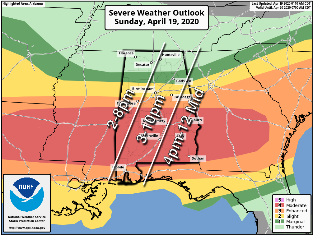
TIMING: The main event will be forming over Mississippi by late morning and pushing into western Alabama by early afternoon. Several rounds of storms will push across the middle of the state through the evening hours until a squall line moves during the late evening and early morning hours.
CALL TO ACTION: Now is the time to review your severe weather safety plan. Check your weather warning sources. Know where you safe place is. Remember that mobile and manufactured homes are not safe in tornadoes or damaging winds. Review our severe weather safety tips for more ideas. Shelter from the storm first: realize that you must protect yourself from the tornado first and the virus second.
NO NEED TO PANIC: We are tired of the virus, we are tired of its impact on our lives, we are tired of severe weather. We will get through it all together.
THE WEEK AHEAD: Monday will be a nice day with quick clearing and mild temperatures in the lower 70s. Tuesday and Wednesday will be nearly perfect with morning lows between 49-52F and highs in the middle and upper 70s.
ANOTHER SEVERE WEATHER EVENT: Another significant severe weather event is likely for Alabama Thursday night. Let’s get through the one at hand before looking at the next one.
WEEKEND OUTLOOK: A passing system will bring more showers and storms Saturday, followed by cooler conditions.
VOODOO COUNTRY: Look for another passing system around Tuesday the 28th, but it doesn’t look especially strong.
BEACHCAST: Windy today and tonight with storms along the beautiful beaches of Alabama and Northwest Florida. A warm week is in store, with. highs near 80. Lows will be in the upper 60s to near 70F. Water temperatures are running around 71F. There is high risk of rip[ currents through Monday morning.
Click here to see the Beach Forecast Center page.
ADVERTISE WITH US: Deliver your message to a highly engaged audience by advertising on the AlabamaWX.com website. The site enjoyed 17.2 MILLION pageviews in the past 12 months. Don’t miss out! We can customize a creative, flexible and affordable package that will suit your organization’s needs. Contact me, Bill Murray, at (205) 687-0782 and let’s talk.
WEATHERBRAINS: This week, the panel will entertain several experts on manufactured housing and tornadoes. You won’t want to miss it! Check out the show at www.WeatherBrains.com. You can also subscribe on iTunes. You can watch the show live at live.bigbrainsmedia.com or on James’ YouTube Channel You will be able to see the show on the James Spann 24×7 weather channel on cable or directly over the air on the dot 2 feed.
ON THIS DATE IN 1970¬¬: Corinth, Mississippi was struck by an F4 tornado that killed 4 people along its 15-mile path. Two of the deaths occurred in a church according to Tom Grazulis, the author of Significant Tornadoes. WeatherBrains’ own Troy Kimmel was a young boy in Corinth and his career path to weather was influenced by the experience. Follow my weather history tweets on Twitter. I am @wxhistorian at Twitter.com.
Category: Alabama's Weather, ALL POSTS, Severe Weather
About the Author (Author Profile)
Bill Murray is the President of The Weather Factory. He is the site's official weather historian and a weekend forecaster. He also anchors the site's severe weather coverage. Bill Murray is the proud holder of National Weather Association Digital Seal #0001 @wxhistorianSubscribe
If you enjoyed this article, subscribe to receive more just like it.


