Today’s Severe Weather Threat In Alabama
Another vigorous spring weather system will impact Alabama today, with the dual threat of severe thunderstorms and flooding.
THIS MORNING: Rain and thunderstorms are over much of Alabama this morning, ahead of a northward moving warm front. These storms are elevated, in a stable airmass, but are still capable of producing small hail, strong, damaging straight line winds, and heavy rain. There is no tornado threat with the morning storms, but remember, straight line winds can produce tornado-like damage. There has been extensive tree damage this morning through parts of Chilton, Coosa, and Tallapoosa counties… winds in spots likely exceeded 80 mph.
THIS AFTERNOON/TONIGHT: An outbreak of tornadoes and severe thunderstorms is expected today from parts of the lower Mississippi Valley across much of the the Southeast, including the southern 2/3 of Alabama. In addition to tornadoes, many of the storms will have very large hail and wind damage. The severe threat will be greatest from north-central Louisiana eastward to southern and central Mississippi, southern and central Alabama into south-central Georgia.
SETUP: The mid-level jet will become coupled with the low-level jet by mid to late afternoon, creating a favorable combination of lift and shear for potentially strong tornadoes. The greatest chance for a regional cluster of tornadoes is forecast from just southeast of Jackson, Mississippi and Hattiesburg, Mississippi eastward across southwest and south-central Alabama in the “moderate risk” area. In addition to the tornado threat, large hail and wind damage will be likely across a large part of the Southeast this afternoon and evening. The wind-damage threat is expected to increase as a mass of thunderstorms moves eastward across southeastern Alabama and into south-central Georgia by early this evening.
SPC has defined a “moderate risk” (level 4/5) for areas south of a line from Eutaw to Jemison to Alexander City to Lafayette, down to just north of Mobile. An “enhanced risk” (Level 3/5) is defined as far north as Tuscaloosa, Hoover, and Wedowee. There is a “slight risk” (level 2/5) up to Sulligent, Remlap, and Piedmont, and a “marginal risk” (level 1/5) is defined as far north as Hamilton, Vinemont, and Fort Payne. No severe storms are expected over the Tennessee Valley
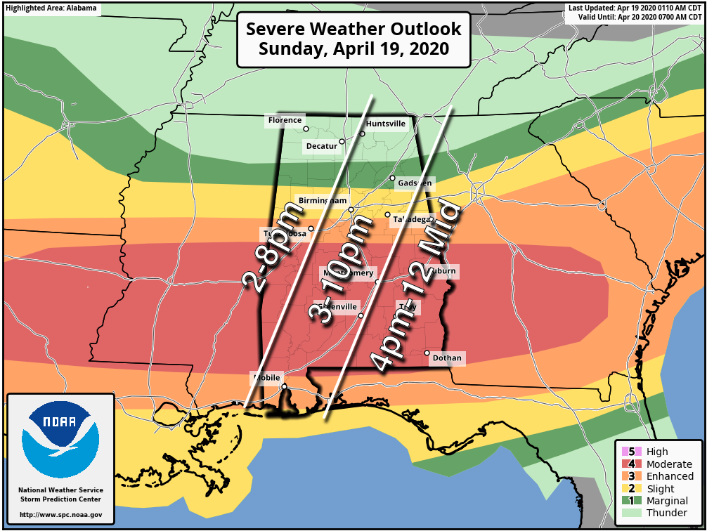
PLACEMENT: The position of the warm front this afternoon will mark the leading edge of the tornado threat. We believe the warm front will be somewhere near, or just south of I-20 (Tuscaloosa to Birmingham to Anniston). North of the warm front over North Alabama, tornado threat is very low, but storms will produce heavy rain and possibly some small hail.
TIMING: The main window for severe thunderstorms will come from 2:00 p.m. until 12:00 midnight. The threat begins initially in West Alabama, shifting eastward through the afternoon and evening hours.
THREATS: Thunderstorms over the southern 2/3 of Alabama will be capable of producing large hail, damaging winds, and a few tornadoes. Strong tornadoes (EF2 or higher) will be possible in the “moderate risk” area.
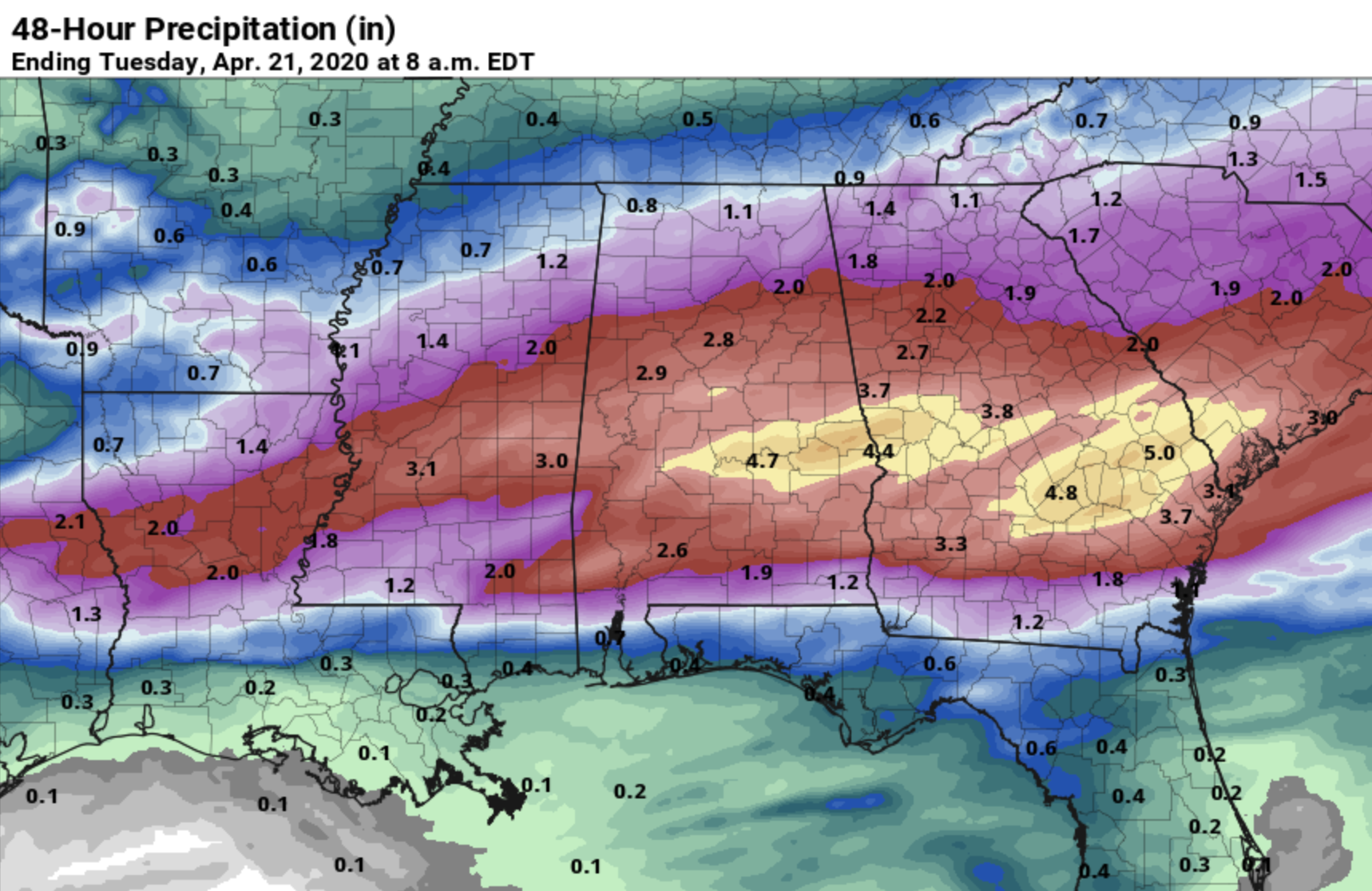
FLOODING: Rain will be heavy at times, and flooding is possible. A flash flood watch is in effect for much of Central and South Alabama where amounts of 2 to 4 inches are expected over the next 48 hours.
CALL TO ACTION: You know the drill; be sure you have a way of hearing severe weather warnings, and an action plan if you are in a tornado warning polygon.
*Have a NOAA Weather Radio in your home and business, properly programmed with a fresh battery in case of power failure.
*Be sure WEA (Wireless Emergency Alerts) enabled on your phone… this is not an app, but built into every phone sold in the U.S. Check settings, and notifications, and be sure emergency alerts are on. Have the free ABC 33/40 weather app on your phone as a secondary way of getting warnings. Search the App Store for “ABC 33/40 Weather” if you don’t have it already.
*In a site built home, identify the safe place. Small room, lowest floor, near the center of the house, away from windows. And, in that safe place, have helmets for everyone in the family (including adults!), portable air horns, and hard sole shoes.
*You can’t stay in a mobile home if you are in a tornado warning polygon. Know the closest shelter, and how to get there quickly.
*Sheltering from a tornado is first priority when it comes to the COVID-19 situation. A tornado is an immediate threat to life; get to your safe place or shelter and do the best you can to protect yourself from exposure to the virus.
As pointed out above, this system most likely won’t produce 24 tornadoes like last Sunday. But, all it takes is one tornado in the entire state. If that one comes through your neighborhood, it is YOUR red letter day. We all have to be prepared.
WATCH US: Remember, when tornado warnings are issued please watch our coverage on ABC 33/40. You don’t need cell service, cable, or satellite… we are free “over the air” TV with an inexpensive antenna. We also stream our coverage on the ABC 33/40 app, the ABC 33/40 web site, and on the ABC 33/40 Facebook page.
ANXIETY: I think Alabamians are tired of dealing with COVID-19, and after last Sunday, tired of dealing with severe weather. We don’t do this to scare anyone, or make them more anxious, but at the same time we have to let you know there is a risk of severe thunderstorms tomorrow. But remember, even on a big severe weather day, odds of any one place being hit by a tornado are low. We will get through the day together.
Category: Alabama's Weather, ALL POSTS, Severe Weather
About the Author (Author Profile)
James Spann is one of the most recognized and trusted television meteorologists in the industry. He holds the AMS CCM designation and television seals from the AMS and NWA. He is a past winner of the Broadcast Meteorologist of the Year from both professional organizations.Subscribe
If you enjoyed this article, subscribe to receive more just like it.


