Tornado Watch Likely For Parts Of Central Alabama Within The Next Few Hours
The latest Mesoscale Discussion from the Storm Prediction Center is out and explains that a tornado watch will most likely be needed for parts of Central Alabama within the next few hours. Here is the text from the discussion:
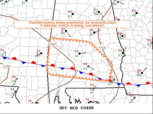
SUMMARY…
Thunderstorms will likely intensify over the next several hours across Central Alabama. Timing of a tornado watch issuance will be dependent on short-term convective trends from storms currently over east-central Mississippi.
DISCUSSION…
Radar imagery shows a west-east cluster of strong thunderstorms located from east-central Mississippi through central Alabama. The thunderstorm activity is located to the north of a composite outflow/warm front draped from the southeast corner of Alabama west-northwestward into central Mississippi. It appears storm development during the next few hours will largely cross the warm front and become elevated but potentially yield some risk for hail/locally damaging gusts.
Later this afternoon and especially during the evening, a mid-level shortwave trough will move east into the ArkLaTex. Additional storm development and storms moving into the area from the west will pose an increasing risk for severe. Low-level shear is forecast to strengthen through the early evening. A tornado risk will tend to focus with any surface-based supercells. However, the damaging wind risk may concentrate with quickly moving bowing segments that may preferentially move eastward along and slightly north of the warm front.
Category: Alabama's Weather, ALL POSTS, Severe Weather
About the Author (Author Profile)
Scott Martin is an operational meteorologist, professional graphic artist, musician, husband, and father. Not only is Scott a member of the National Weather Association, but he is also the Central Alabama Chapter of the NWA president. Scott is also the co-founder of Racecast Weather, which provides forecasts for many racing series across the USA. He also supplies forecasts for the BassMaster Elite Series events including the BassMaster Classic.Subscribe
If you enjoyed this article, subscribe to receive more just like it.


