Latest Severe Weather Outlook Is Out, Unchanged For North Central Alabama
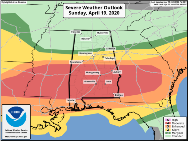
A LEVEL 4 MODERATE RISK through the rest of the day and into the early morning hours on Monday for locations along and south of a line from Union (Greene Co.) to Jemison (Chilton Co.) to Alexander City (Tallapoosa Co.). Strong tornadoes, damaging winds up to and exceeding 70 MPH, and large hail up to golf ball size will be possible with any severe storms over the Moderate Risk area.
A LEVEL 3 ENHANCED RISK continues for locations north of that to as far north as Carrollton (Pickens Co.) to Saginaw (Shelby Co.) to Malone (Randolph Co.). Tornadoes, damaging winds up to and exceeding 70 MPH, and large hail up to golf ball size will be possible with any severe storms over the Enhanced Risk area.
A LEVEL 2 SLIGHT RISK continues north of that to as far north as just above Vernon (Lamar Co.) to Warrior (Jefferson Co.) to Jacksonville (Calhoun Co.). Damaging winds up to 60 MPH and large hail up to quarter size will be possible with any severe storms over the Slight Risk area. The tornado threat is very, very small, but not at zero.
A LEVEL 1 MARGINAL RISK continues north of that to as far north as Haleyville (Winston Co.) to Baileyton (Cullman Co.) to Little River (Cherokee Co.). Isolated damaging winds up to 60 MPH and isolated large hail up to quarter size is possible, but not likely over the Marginal Risk area.
Strong to severe storms are likely this afternoon and overnight, mainly from now through 2:00 am Monday morning. The greatest threat for severe storms and the tornado threat should remain across the southern half of Central Alabama (along and south of Sumter County to Chilton County to Chambers County). Strong tornadoes, damaging winds up to 80 MPH and golf ball size will be possible in this area. To the north, a few storms could produce damaging winds and quarter size hail. Thunderstorms with heavy rainfall may result in flash flooding.
Category: Alabama's Weather, ALL POSTS, Severe Weather
About the Author (Author Profile)
Scott Martin is an operational meteorologist, professional graphic artist, musician, husband, and father. Not only is Scott a member of the National Weather Association, but he is also the Central Alabama Chapter of the NWA president. Scott is also the co-founder of Racecast Weather, which provides forecasts for many racing series across the USA. He also supplies forecasts for the BassMaster Elite Series events including the BassMaster Classic.Subscribe
If you enjoyed this article, subscribe to receive more just like it.


