More Strong Storms Impacting Greene & Sumter Counties
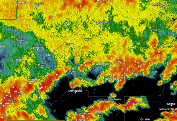
At 3:48 pm, a strong thunderstorm capable of producing half-inch hail and winds in excess of 40 mph located over York, moving east at 45 mph.
Heads up if you’re located in Livingston, York, Cuba, Forkland, Epes, Boyd, The University Of West Alabama, Bluffport, Thornhill, Coatopa, Dug Hill, Tishabee, Old Mallard Airport, Belmont, Lilita, McDowell, and Five Points Intersection. Frequent cloud to ground lightning is occurring with this storm. Lightning can strike 10 miles away from a thunderstorm. Seek a safe shelter inside a building or vehicle.
Category: Alabama's Weather, ALL POSTS, Severe Weather
About the Author (Author Profile)
Scott Martin is an operational meteorologist, professional graphic artist, musician, husband, and father. Not only is Scott a member of the National Weather Association, but he is also the Central Alabama Chapter of the NWA president. Scott is also the co-founder of Racecast Weather, which provides forecasts for many racing series across the USA. He also supplies forecasts for the BassMaster Elite Series events including the BassMaster Classic.Subscribe
If you enjoyed this article, subscribe to receive more just like it.


