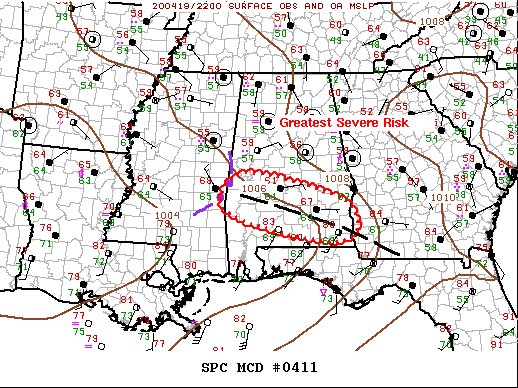
Greatest Severe Risk Is Over Extreme Southern Parts Of Central Alabama
This is the latest Mesoscale Discussion from the StormPrediction Center:
SUMMARY…
Tornado threat continues across the southern two-thirds of the Tornado Watch area.
DISCUSSION…
Early-day convection that spread across GA has forced a well-defined boundary south and a bit west arcing across the Tornado Watch area. Latest surface obs suggest this wind shift extends from Henry – Butler – Marengo Counties in AL, immediately ahead of a surging squall line. Over the last few hours, an MCV has evolved along the northern edge of a pronounced squall line that is surging east in excess of 45kt. Thunderstorms have struggled to develop across the warm sector, possibly due to somewhat weak low-level convergence. While the air mass has warmed across southern MS into southern AL, the primary concern in the near-term will be along the aforementioned boundary which should serve as the focus for upstream convection to propagate along. While the primary storm mode remains linear with clusters, strong shear continues to support supercells; although, the most likely region for supercells will be across the warm sector where storms have struggled to develop.
Category: Alabama's Weather, ALL POSTS, Severe Weather
About the Author (Author Profile)
Scott Martin is an operational meteorologist, professional graphic artist, musician, husband, and father. Not only is Scott a member of the National Weather Association, but he is also the Central Alabama Chapter of the NWA president. Scott is also the co-founder of Racecast Weather, which provides forecasts for many racing series across the USA. He also supplies forecasts for the BassMaster Elite Series events including the BassMaster Classic.Subscribe
If you enjoyed this article, subscribe to receive more just like it.


