Update Just Before 10:00 PM: Severe Threat Is Nearly Over For Central Alabama
As of the latest update from NWS Birmingham, the warm front has really been hung up over South Alabama and has failed to make much progress northward through the evening hours. Rain-cooled and stable air really stunted the northward movement of the front.
Therefore, all of the Central Alabama counties, with the exception of Pike and Barbour counties, have been removed from the Tornado Watch that is set to expire at 11:00 pm tonight. Those are the only two counties where the warmer air is not that far south of those counties and the warm front may move across those counties with time tonight and into the overnight hours before the remainder of the system moves through.
Text from NWS Birmingham’s latest Hazardous Weather Outlook:
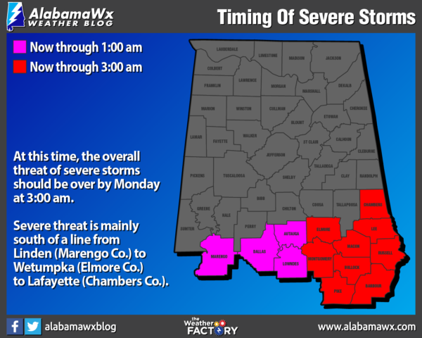
Strong to severe storms are possible into the overnight hours, mainly through 3 AM. The greatest threat for severe storms and the tornado threat should remain across the far southeast counties of Central Alabama or along and south of a line from Troy to Eufaula. Tornadoes, damaging winds up to 60 mph and quarter size will be possible in this area. To the north, along and south of a Linden to Wetumpka to Lafayette line, a few storms could produce damaging winds and quarter size hail. Thunderstorms with heavy rainfall may result in flash flooding.
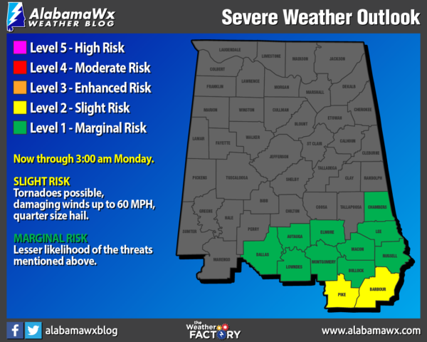
There is a LEVEL 1 MARGINAL RISK up for locations along and south of a line from Miller (Marengo Co.) to Booth (Autauga Co.) to Lafayette (Chambers Co.).
A LEVEL 2 SLIGHT RISK is up for locations along and south of a line from Orion (Pike Co.) to Inverness (Bullock Co.) to Comer (Barbour Co.)
Tornadoes remain possible along with damaging winds up to 60 MPH and quarter size hail in the Slight Risk locations. Those same threats are possible but are less likely in the Marginal Risk locations.
Our next threat of severe storms, including the threat of tornadoes, looks to come on Thursday.
Category: Alabama's Weather, ALL POSTS, Severe Weather
About the Author (Author Profile)
Scott Martin is an operational meteorologist, professional graphic artist, musician, husband, and father. Not only is Scott a member of the National Weather Association, but he is also the Central Alabama Chapter of the NWA president. Scott is also the co-founder of Racecast Weather, which provides forecasts for many racing series across the USA. He also supplies forecasts for the BassMaster Elite Series events including the BassMaster Classic.Subscribe
If you enjoyed this article, subscribe to receive more just like it.


