New Tornado Watch Coming Soon For Southeast Alabama
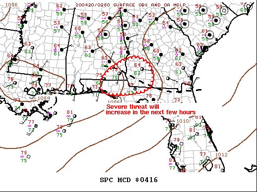
This new tornado watch should stay out of Central Alabama, but with portions of Pike and Barbour counties in the circled area, I thought I would go ahead and post about it. Here is the latest Mesoscale Discussion from the Storm Prediction Center:
SUMMARY…
A new Tornado Watch will likely be issued within the hour.
DISCUSSION…
An expansive area of convection has evolved across MS/AL/GA late this evening. This activity is suppressing higher instability to within 50-80 miles of the Gulf Coast as the convective outflow is reinforced along the southern fringe of the precip shield. 00z (7 pm) sounding from TLH exhibited a strong cap at 850mb, through steep mid-level lapse rates and strong deep-layer shear will be supportive of organized robust updrafts. Over the last hour or so, numerous showers have begun to develop off the Coast into western FL Panhandle. This may be indicative of a weakening cap in response to approaching large-scale forcing for ascent. There is increasing concern that convection will gradually deepen across this region and strong thunderstorms may ultimately evolve into the early-morning hours. If so, this activity would track east into southwestern GA where a favorably-draped outflow boundary could provide the focus supercells and possible tornadoes.
Category: Alabama's Weather, ALL POSTS, Severe Weather
About the Author (Author Profile)
Scott Martin is an operational meteorologist, professional graphic artist, musician, husband, and father. Not only is Scott a member of the National Weather Association, but he is also the Central Alabama Chapter of the NWA president. Scott is also the co-founder of Racecast Weather, which provides forecasts for many racing series across the USA. He also supplies forecasts for the BassMaster Elite Series events including the BassMaster Classic.Subscribe
If you enjoyed this article, subscribe to receive more just like it.


