Flash Flood Watch Has Been Extended Until 4:00 AM Monday Morning
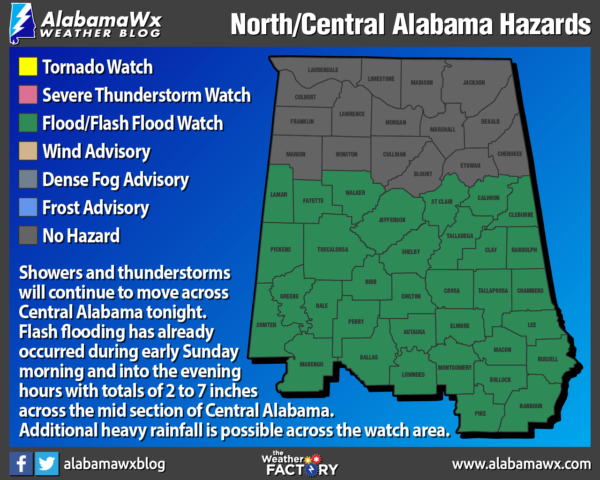
NWS Birmingham has extended the FLASH FLOOD WATCH in time for Autauga, Barbour, Bibb, Bullock, Calhoun, Chambers, Chilton, Clay, Cleburne, Coosa, Dallas, Elmore, Fayette, Greene, Hale, Jefferson, Lamar, Lee, Lowndes, Macon, Marengo, Montgomery, Perry, Pickens, Pike, Randolph, Russell, Shelby, St. Clair, Sumter, Talladega, Tallapoosa, Tuscaloosa, and Walker counties until 4:00 am Monday morning.
Heavy Rain and Flash Flooding Expected Through Tonight…
Showers and thunderstorms will continue to move across Central Alabama through tonight. Flash flooding has already occurred during early Sunday morning and into the evening hours with totals of 2 to 7 inches across the midsection of Central Alabama. Continued heavy rainfall from showers and thunderstorms will result in an additional inch or so of rain with locally higher amounts.
A Flash Flood Watch means that conditions may develop that lead to flash flooding. Flash flooding is a very dangerous situation. You should monitor later forecasts and be prepared to take action should Flash Flood Warnings be issued.
Category: Alabama's Weather, ALL POSTS, Severe Weather
About the Author (Author Profile)
Scott Martin is an operational meteorologist, professional graphic artist, musician, husband, and father. Not only is Scott a member of the National Weather Association, but he is also the Central Alabama Chapter of the NWA president. Scott is also the co-founder of Racecast Weather, which provides forecasts for many racing series across the USA. He also supplies forecasts for the BassMaster Elite Series events including the BassMaster Classic.Subscribe
If you enjoyed this article, subscribe to receive more just like it.


