Strong Storms Affecting Lowndes & Dallas Counties
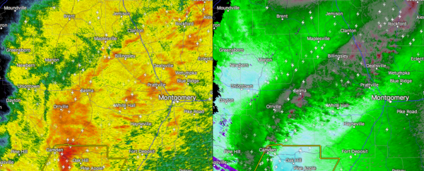
At 6:17 AM CDT, Doppler radar was tracking a strong thunderstorm near Dannelly Reservoir, or 14 miles northeast of Camden, moving east at 55 mph. Winds in excess of 40 mph will be possible with this storm.
Locations impacted include…
Fort Deposit, Mosses, Hayneville, White Hall, Gordonville, Orrville, Lowndesboro, Benton, Beechwood, Tyler, Old Cahaba Park, Dannelly Reservoir, Lowndes County Airport, Belknap, Dallas Lake, Logan, Davenport, Calhoun, Carlowville, and Minter.
Torrential rainfall is also occurring with this storm and may lead to localized flooding. Do not drive your vehicle through flooded roadways.
To report severe weather, contact your nearest law enforcement agency. They will relay your report to the National Weather Service office in Birmingham.
Category: Alabama's Weather, ALL POSTS, Severe Weather
About the Author (Author Profile)
Scott Martin is an operational meteorologist, professional graphic artist, musician, husband, and father. Not only is Scott a member of the National Weather Association, but he is also the Central Alabama Chapter of the NWA president. Scott is also the co-founder of Racecast Weather, which provides forecasts for many racing series across the USA. He also supplies forecasts for the BassMaster Elite Series events including the BassMaster Classic.Subscribe
If you enjoyed this article, subscribe to receive more just like it.


