A Brief Update Just Before 8:00 AM
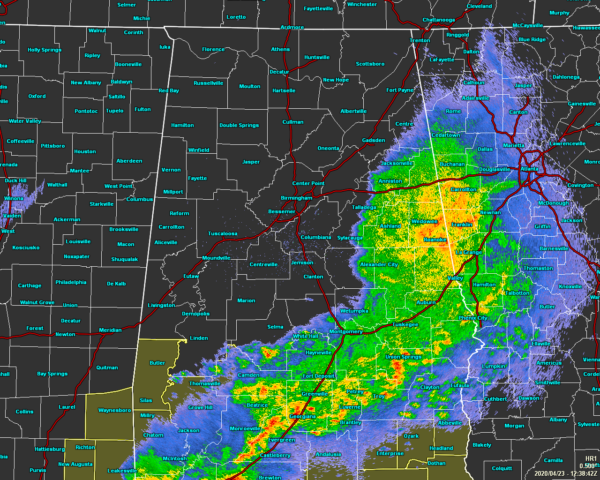
As of 7:39 am, much of the shower and thunderstorm activity with this first wave of storms is pushing through the eastern and southeastern parts of the area and will be exiting the area within the next hour or two. The good news is that most of these storms have stayed well-behaved, but we did have some damage reported in Hale County of numerous trees downed.
We do seem to have a gravity wave that has formed on the backside of the activity that will bring some brief gusty winds up to 40-50 MPH that could bring down some trees as the ground will be weaker due to being saturated. Please stay weather aware as the rain comes to an end for your location as winds may briefly become strong.
Wind damage has just been reported on NWS Chat for portions of Fort Payne and Sand Mountain as power has been knocked out and a portion of roofing has been removed from a building.
The rest of North/Central Alabama has now dried out and now the waiting game begins to see if the atmosphere can destabilize again to allow strong to severe storms to form, including supercells capable of producing tornadoes, damaging winds, and large hail, and move across the area this afternoon and into the evening.
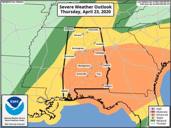
SPC continues a LEVEL 3 ENHANCED RISK includes locations along and south of a line from Cuba (Sumter Co.) to Samantha (Tuscaloosa Co.) to Birmingham (Jefferson Co.) to Heflin (Cleburne Co.). A LEVEL 2 SLIGHT RISK includes the rest of North/Central Alabama north of the Enhanced Risk with the exceptions of locations along and north of a line from Bexar (Marion Co.) to Florence (Lauderdale Co.). A LEVEL 1 MARGINAL RISK includes locations along and north of a line from Bexar (Marion Co.) to Florence (Lauderdale Co.).
The main window for the potential of stronger to severe storms will be from 12:00 pm to 3:00 pm for the western-third of the area, from 2:00 pm to 5:00 pm for the central-third, and from 4:00 pm to 7:00 pm for the eastern-third of North/Central Alabama.
Category: Alabama's Weather, ALL POSTS, Severe Weather
About the Author (Author Profile)
Scott Martin is an operational meteorologist, professional graphic artist, musician, husband, and father. Not only is Scott a member of the National Weather Association, but he is also the Central Alabama Chapter of the NWA president. Scott is also the co-founder of Racecast Weather, which provides forecasts for many racing series across the USA. He also supplies forecasts for the BassMaster Elite Series events including the BassMaster Classic.Subscribe
If you enjoyed this article, subscribe to receive more just like it.


