Enhanced Risk Removed From Nearly All Of Central Alabama
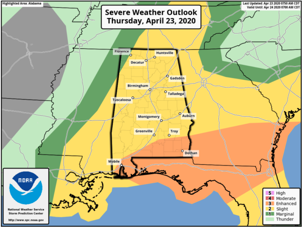
The latest update from the Storm Prediction Center shows that the LEVEL 3 ENHANCED RISK has been removed for everyone in North/Central Alabama with the exception of the extreme southern portions of Pike and Barbour counties. The LEVEL 2 SLIGHT RISK remains the same, nearly covering the rest of North/Central Alabama with the exception of the northwest corner of the area, where a LEVEL 1 MARGINAL RISK exists. Here is the text from the SPC:
THERE IS AN ENHANCED RISK OF SEVERE THUNDERSTORMS ACROSS PARTS OF SOUTHERN ALABAMA…SOUTHERN GEORGIAN…FLORIDA PANHANDLE AND NORTHERN FLORIDA.
SUMMARY…
The greatest potential for severe thunderstorms today is from parts of southern Alabama eastward across parts of southern Georgia and the Florida Panhandle/North Florida. Tornadoes and severe wind will be the main concerns.
Synopsis…
In mid/upper levels, a series of shortwaves will contribute to increasingly cyclonic large-scale flow across much of the central CONUS. The leading of these perturbations, and most crucial for this forecast, is apparent in moisture-channel imagery from a circulation over southern/central MO southwestward across eastern OK, north TX, and northern Coahuila. This trough will deamplify gradually through the period, but remain fairly well-defined, extending by 00Z from the lowermost Ohio Valley to the upper/middle TX Coast. It should reach eastern portions of KY/TN, northern GA and southern AL by the end of the period.
At the surface, 11Z analysis showed a surface cyclone over the MO/AR Ozarks, with occluded front to northern LA, and cold front southwestward across the mid/upper TX Coastal Plain. The low should move eastward across portions of western/central KY by 00Z, with occluded/cold front across middle TN, central/western AL, and southern LA. By 12Z that front should extend from the low across central/eastern GA and parts of the FL Panhandle to the north-central Gulf. A warm front was drawn from southwestern AL southeastward over the northeastern Gulf and should move northeastward across the FL Panhandle, southeastern AL, and parts of southern GA today before being overtaken by convection.
Southeastern U.S…
Severe potential today appears most concentrated with a leading complex of severe thunderstorms, initially moving eastward across portions of southern AL and extreme southeastern MS. For near-term details, see tornado watch 139 and related SPC mesoscale discussions.
This complex should continue to offer a tornado/wind-damage risk, with isolated/marginally severe hail also possible, as it crosses the Gulf Coastal Plain and eastward to either side of the Florida/Georgia line, through early afternoon. Additional convection should develop in a comparatively undisturbed air mass to its southwest — perhaps along a trailing outflow/convergence boundary — later this afternoon through tonight. The buoyancy/shear parameter space will be greatest near the Gulf Coast, along and south of the warm front. The area near the front should exhibit enhancement of low-level hodograph size, inflow-layer vorticity, and storm-relative boundary-layer winds, with 200-400 J/kg effective SRH and 45-55-kt effective-shear magnitudes.
In addition to destabilization inland related to warm-frontal passage, muted diurnal heating is expected beneath the anvil-cloud cover. Theta-e advection inland from the Atlantic over parts of southeastern GA also should contribute. The northward extent of the destabilization favorable for surface-based inflow is uncertain but increasingly appears to be not as vigorous as suggested by earlier guidance, due to the MCS’ projected translation relative to the inland pace of the warm front, and its spread of down shear precip/clouds well northeastward across GA/Carolinas. As such, some southward shunting of the northern probability lines is warranted. In addition, a band of strong-severe convection may shift as far south as central FL by the end of the period.
Severe potential still exists with a possible second episode, along/ahead of the cold front from the Tennessee Valley region southward, but is very conditional. Substantial stabilization to near the Gulf Coast is associated with the leading MCS. Only a narrow back door of at least marginally favorable theta-e advection and related airmass recovery will exist to the west, which comes with offsetting influences:
1. Southwesterly near-surface flow ahead of the front will yield the best trajectories for theta-e recovery around the morning MCS outflow, but also contribute to relatively reduced low-level shear and convergence.
2. Any southerly to southeasterly trajectories from the MCS passage will be more convectively stabilized.
Still, a narrow plume of favorable buoyancy may develop — with MLCAPE ranging from around 500-1000 J/kg in the north where deep lift, cooling aloft and shear will be greatest, to around 2000 J/kg in the south under weaker ascent and shear. With uncertain coverage, duration and intensity of convection in this regime, the risk level is not as great as farther southeast and should diminish markedly after dark.
Category: Alabama's Weather, ALL POSTS, Severe Weather
About the Author (Author Profile)
Scott Martin is an operational meteorologist, professional graphic artist, musician, husband, and father. Not only is Scott a member of the National Weather Association, but he is also the Central Alabama Chapter of the NWA president. Scott is also the co-founder of Racecast Weather, which provides forecasts for many racing series across the USA. He also supplies forecasts for the BassMaster Elite Series events including the BassMaster Classic.Subscribe
If you enjoyed this article, subscribe to receive more just like it.


