A Quick Midday Check On Our Weather Situation
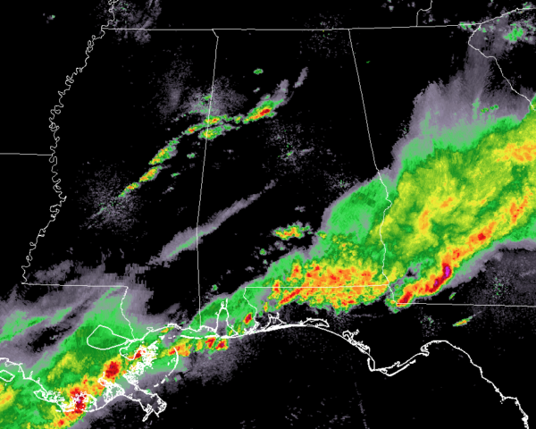
At 11:35 am, we have a few scattered showers that have formed over the west-central parts of Central Alabama that are moving into an environment that was worked over pretty well earlier this morning. There is simply no instability for these storms to work with, so the likelihood of these growing severe are really low at this point.
Notice all of the activity to our south along the Gulf Coast and back into Louisiana. That activity may just keep the flow of energy from reaching Central Alabama during the afternoon and early evening hours and shunting our potential for severe storms.
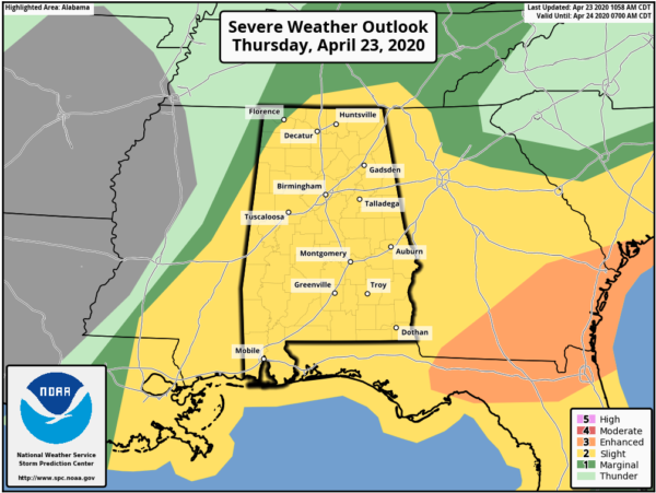
The latest update from the Storm Prediction Center has now completely removed the LEVEL 3 ENHANCED RISK from all of Alabama and keeps us mainly in a LEVEL 2 SLIGHT RISK with the exception of the extreme northwestern corner of the state as it is in a LEVEL 1 MARGINAL RISK.
NWS Birmingham is in the process of canceling the Flash Flood Watch and the Wind Advisory that is currently in effect.
We’ll continue to have a chance for scattered showers and thunderstorms throughout the rest of the afternoon and into the evening hours, but the likelihood of those becoming severe has been greatly reduced. We can still see a storm or two with damaging winds up to 60 MPH and large hail up to quarter size, but I think we will be catching a well-deserved break from overall severe weather. We’ll still have to keep an eye open as the activity could end along the coast and allow that energy to move up into the area. Highs look to top out in the lower to mid-70s across the area.
Rain will come to an end from west to east later tonight and skies will begin the clearing process during the overnight hours. Showers and storms could linger around into the late-night hours for the extreme southeastern parts of the area, but once again, severe storms are not likely now. Lows will be in the 50s throughout the area.
Category: Alabama's Weather, ALL POSTS, Severe Weather
About the Author (Author Profile)
Scott Martin is an operational meteorologist, professional graphic artist, musician, husband, and father. Not only is Scott a member of the National Weather Association, but he is also the Central Alabama Chapter of the NWA president. Scott is also the co-founder of Racecast Weather, which provides forecasts for many racing series across the USA. He also supplies forecasts for the BassMaster Elite Series events including the BassMaster Classic.Subscribe
If you enjoyed this article, subscribe to receive more just like it.


