A Quick Peek Into Our Severe Weather Potential For Today
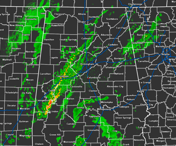
At 5:50 am, the good news is that radar shows the line of showers that have moved in this morning have weakened to just general rain. Some of the rainfall within the line is moderate to heavy in intensity, but that is really it. The line stretches from roughly Baileyton (Cullman Co.) to Tuscaloosa (Tuscaloosa Co.) to Forkland (Greene Co.). This line is moving into an atmosphere that has a little bit of instability, but there is a good cap in place which will keep this line well-behaved has it moves off to the east and eventually falling apart.
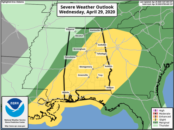
As of the latest update from the Storm Prediction Center, the risk levels continue to be pretty much in the same locations as of my last update last night…
A LEVEL 2 SLIGHT RISK is up for all locations along and south of a line from Livingston (Sumter Co.) to Gorgas (Walker Co.) to Paint Rock (Jackson Co.) to Ider (Dekalb Co.).
A LEVEL 1 MARGINAL RISK is up north of that to a line from Bexar (Marion Co.) to Lester (Limestone Co.).
The main threat will be from damaging straight-line thunderstorm wind gusts up to 60 MPH. There will be a smaller threat of some hail and an even smaller threat of a brief tornado or two, but it is not likely that we’ll see a tornado. The main threat window for stronger to severe storms has been adjusted due to this first line of showers coming in a little weaker. Now, the window starts this morning at 11:00 am and is expected to close as late as 7:00 pm this evening.
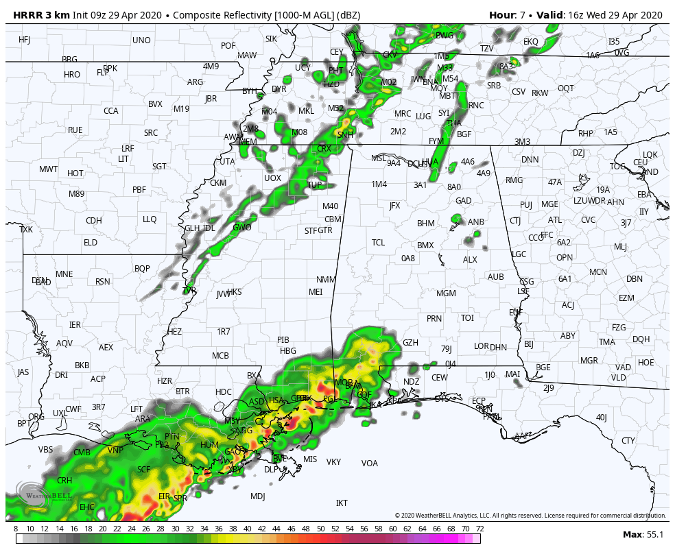
The above radar simulation is from the latest run of the HRRR starting at 11:00 am and ending at 7:00 pm. It shows that another wave of showers and thunderstorms is expected to form mainly back in Tennessee and northern parts of Mississippi and move eastward through North/Central Alabama. This will be a conditional threat for severe storms as there will be some activity over the Gulf Coast that may shunt the energy from moving up into North/Central Alabama. Another limiting factor will be the cloud cover over the area.
With this model run, it is depicting that instability will be able to form ahead of the second wave of storms, reaching as high as 2000 J/kg in the southeastern parts of the area. The good news is that much of the helicity needed for rotating updrafts will be over Georgia and up into the mountains of Tennessee and the Carolinas. There will be a couple of pockets that will be supportive of rotating updrafts, but those will be very small at best. The better wind shear values will also be mostly behind the second wave of storms as well, so the severe threat will be limited.
Forecast soundings for the extreme southeastern portions of the area off of the same run show that there is a very small tornado threat as ingredients will be just high enough for that possibility. Shear and lapse rates will be just high enough to be supportive of severe storms, but helicity will be meager at best. Therefore, a brief spinup tornado may be possible.
We’ll continue to have updates throughout the day so stay tuned.
Category: Alabama's Weather, ALL POSTS, Severe Weather
About the Author (Author Profile)
Scott Martin is an operational meteorologist, professional graphic artist, musician, husband, and father. Not only is Scott a member of the National Weather Association, but he is also the Central Alabama Chapter of the NWA president. Scott is also the co-founder of Racecast Weather, which provides forecasts for many racing series across the USA. He also supplies forecasts for the BassMaster Elite Series events including the BassMaster Classic.Subscribe
If you enjoyed this article, subscribe to receive more just like it.


