SPC Updates Severe Weather Risks; Shrinks Slight Risk Area
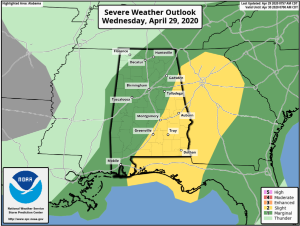
The latest Day 1 Severe Weather Outlook is out from the Storm Prediction Center and they have decided to shrink the area of the slight risk to just include the extreme eastern parts and the southeastern parts of Central Alabama for today. Just about the rest of North/Central Alabama remains in a marginal risk. No change in the timing for the potential for strong to severe storms… 11:00 am to 7:00 pm.
LEVEL 2 SLIGHT RISK:
Locations along and east of a line from Fort Deposit (Lowndes Co.) to Alexander City (Tallapoosa Co.) to Forney (Cherokee Co.).
LEVEL 1 MARGINAL RISK:
Locations north and west of the slight risk to as far north as Bexar (Marion Co.) to Lester (Limestone Co.).
Here is the text from the latest Severe Weather Outlook from the Storm Prediction Center:
…SUMMARY…
Isolated severe thunderstorms capable of producing mainly damaging wind gusts may occur today into tonight across parts of the Southeast States.
…Middle Gulf Coast/Southeast States…
A large-scale trough will continue to amplify and spread east-southeastward over the region through tonight. An extensive squall line extends from the middle Texas Coast to eastern Louisiana/far southeast Mississippi early this morning.
Considerable convective overturning and residual trajectories will decidedly influence/hinder air mass destabilization today ahead of an eastward-advancing cold front that will spread from the Mississippi Valley vicinity this morning across the Tennessee Valley today and toward the southern Appalachians/Southeast by tonight. These squall line/outflow-related thermodynamic impacts and residual cloud cover will likely tend to limit the overall severe risk.
That said, a pocket of weakly unstable air, coincident with lower 60s F surface dewpoints, resides across parts of Alabama and the western Florida Panhandle early today to the east of the thicker cloud shield and remnant outflow influences. Thunderstorms should redevelop and diurnally intensify later this afternoon, most probable across southeast Alabama/Florida Panhandle into Georgia. Pending the degree of destabilization, some of these storms could be severe within a strongly sheared environment. Influenced by the arrival of somewhat stronger forcing for ascent late today/tonight, these storms could further increase and organize in a quasi-linear fashion by evening across Georgia into the Carolinas within a modestly unstable environment. Overall, locally damaging winds should be the primary risk, although a tornado threat cannot be ruled out.
Category: Alabama's Weather, ALL POSTS, Severe Weather
About the Author (Author Profile)
Scott Martin is an operational meteorologist, professional graphic artist, musician, husband, and father. Not only is Scott a member of the National Weather Association, but he is also the Central Alabama Chapter of the NWA president. Scott is also the co-founder of Racecast Weather, which provides forecasts for many racing series across the USA. He also supplies forecasts for the BassMaster Elite Series events including the BassMaster Classic.Subscribe
If you enjoyed this article, subscribe to receive more just like it.


