At Midday, We Have Some Sun, Some Clouds, & Some Showers
The cold front continues to work through Central Alabama as we have reached the 11:00 am hour at the beginning of the workweek. Skies are partly cloudy across much of the area with more clouds and some shower activity mainly along and south of the I-85 and US-80 corridors in the southern parts of the area. Temperatures as of the 11:00 am roundup were in the mid-70s to the lower 80s across the area. Montgomery was the warm spot at 83 degrees. A few locations were tied as the cool spots at 74 degrees. Birmingham was sitting at 76 degrees.
We’ll continue to have a chance of showers and thunderstorms throughout the afternoon and into the evening hours, with rain chances coming to an end for locations west of I-65 by roughly 8:00 pm tonight and east of I-65 by midnight. A few storms may become strong with gusty winds and small hail, but we do not expect any severe weather. Afternoon highs will be in the mid-70s to the mid-80s across the area. As mentioned earlier, the rain will come to an end by midnight for all of Central Alabama and skies will be clearing. Overnight lows will be in the mid-50s to the lower 60s.
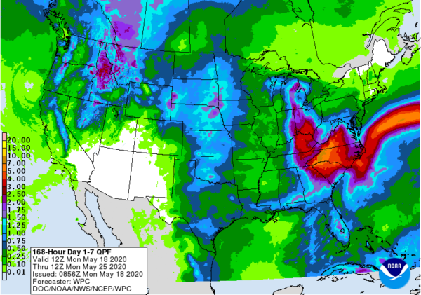
For the rest of the week and through the weekend, we’ll have an upper low that will become mainly stationary just to the north of us between the Great Lakes and the Tennessee Valley. There will also be a front that will stall out and stay draped over the southern portions of Alabama and possibly over the extreme southeastern parts of Central Alabama. With the combination of both of those, we’ll have cooler temperatures and a good supply of sunshine, but we’ll also have a slight chance of isolated showers or storms each day through Thursday. The heat will begin to return on Friday and stay with us through the weekend, so will the small chance of scattered afternoon showers and storms. Rainfall amounts look to be in the 1/2-inch to 1-1/2 inch range from west to east throughout the week and weekend. Here is the breakdown of afternoon highs:
Tuesday: lower 70s – lower 80s
Wednesday: mid-70s – lower 80s
Thursday: lower 80s – mid-80s
Friday: lower 80s – lower 90s
Saturday: upper 80s – lower 90s
Sunday: upper 80s – mid-90s
Memorial Day looks to be the same as there will be a small chance of scattered showers and thunderstorms mainly during the afternoon and evening hours. Highs at this point look to be in the upper 80s to the mid-90s. Looks like summertime will make its presence felt early.
Category: Alabama's Weather, ALL POSTS


