Latest Mesoscale Discussion: Watch Not Likely At This Time
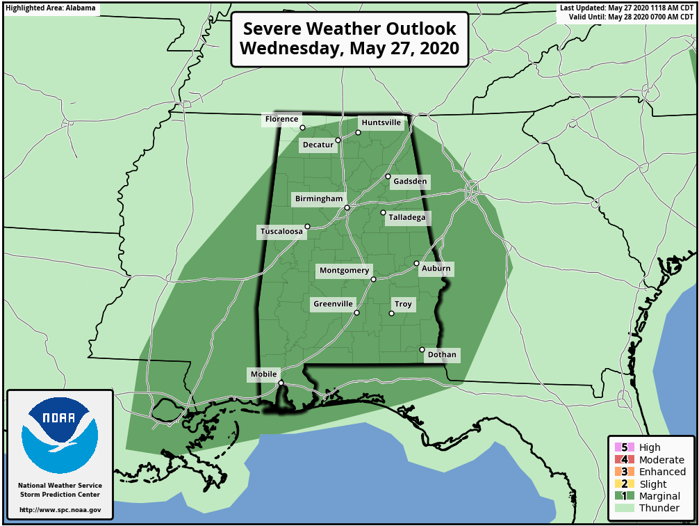
The Storm Prediction Center has nearly all of the state of Alabama in a LEVEL 1 MARGINAL RISK for severe storms through the rest of your Wednesday. Scattered showers and storms will continue to develop throughout the afternoon and move across Central Alabama. Damaging winds up to 60 MPH will be the main threat during a window from now until at least 10:00 pm tonight.
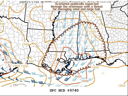
Here is the text from the Storm Prediction Center:
SUMMARY…Scattered multicells are expected to continue through the afternoon with a threat for damaging winds and large hail.
DISCUSSION…Scattered storms have developed this morning across southeast Louisiana into southern Mississippi and southern Alabama. Expect additional storms to continue to form throughout the day in the same region. MLCAPE has increased to around 2000 J/kg amid temperatures in the low to mid-80s and dewpoints in the low 70s. The 12Z LIX RAOB and 17Z VWP shows mid-level flow around 35 knots which has yielded effective shear around 35 to 40 knots in the region. This will support some updraft organization with mostly multicell clusters and occasional transient supercell structures possible. Weak flow in the lowest 3 km will be the primary limiting factor to a greater severe weather threat, but given the moderate instability and mid-level lapse rates around 7 C/km (per 12Z LIX RAOB) some strong downbursts and occasional large hail are possible. The damaging wind threat may be enhanced in any regions where localized clustering can create a cold pool and enhance the damaging wind threat. However, winds will still likely be mostly sub-severe given the aforementioned weak lower-tropospheric flow.
In addition, the best-organized convection at this time is currently in southwest Alabama and will be moving into a more hostile environment with warmer temperatures aloft and a cooler boundary layer due to morning clouds. Therefore, this activity is likely near its peak intensity at this time.
Organization of additional storms developing across southeast Louisiana and southern Mississippi will continue to be monitored through the afternoon, and if a more organized severe weather threat materializes a watch may need to be considered.
Category: Alabama's Weather, ALL POSTS, Severe Weather
About the Author (Author Profile)
Scott Martin is an operational meteorologist, professional graphic artist, musician, husband, and father. Not only is Scott a member of the National Weather Association, but he is also the Central Alabama Chapter of the NWA president. Scott is also the co-founder of Racecast Weather, which provides forecasts for many racing series across the USA. He also supplies forecasts for the BassMaster Elite Series events including the BassMaster Classic.Subscribe
If you enjoyed this article, subscribe to receive more just like it.


