10 p.m. Look at Tropical Storm Cristobal and Its Impacts for the Gulf Coast
FAST FACTS ON TROPICAL STORM CRISTOBAL AT 10 PM
———————————————–
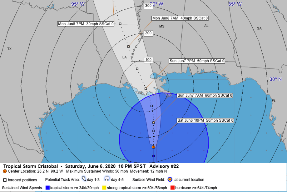
LOCATION…26.2N 90.2W
ABOUT 210 MI SSW OF THE MOUTH OF THE MISSISSIPPI RIVER
MAXIMUM SUSTAINED WINDS…50 MPH
PRESENT MOVEMENT…N OR 360 DEGREES AT 12 MPH
MINIMUM CENTRAL PRESSURE…993 MB…29.33 INCHES
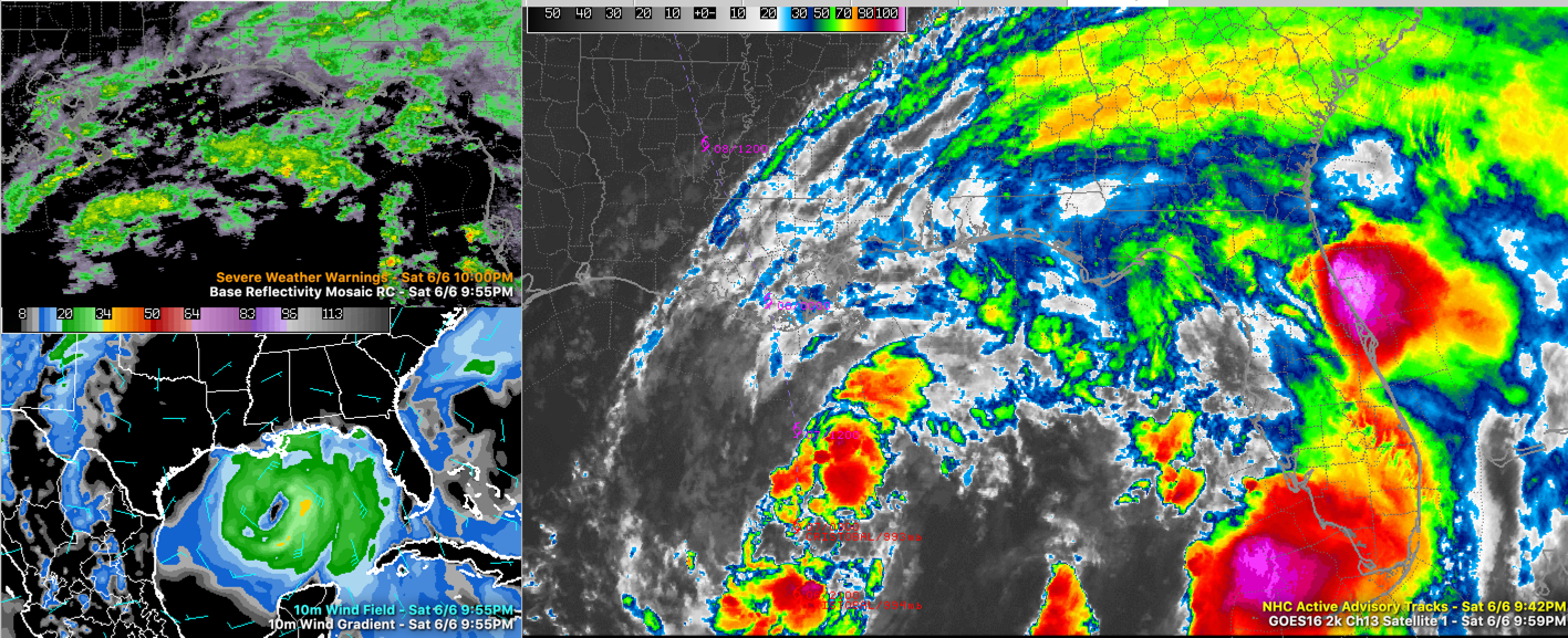
Tropical Storm Cristóbal is moving toward landfall on the Louisiana coast Sunday evening as a disorganized but impactful storm. The storm is tropical, but barely so, exhibiting many subtropical characteristics. Here is the latest satellite imagery, radar, and wind field:
Most of the effects will be felt to the west of Alabama, but we will get some rainfall from the outer feeder bands and along with that, there is a chance of some tornadic activity. In our state, the closer you are to the Mississippi border, the greater the potential impact.
THE LATEST ON THE TROPICAL STORM: As of 10 p.m. CDT, the center of Tropical Storm Cristóbal is located about 230 miles south southeast of Houma, LA, or about 150 miles south of New Orleans. It is moving north northwest at 10 mph. The storm has maximum sustained winds of 50 mph. The central pressure is 993 MB, as measured by a buoy that the center passed over a short time ago. Some slow strengthening is possible until the storm’s center moves inland Sunday evening, but it is not expected to become a hurricane. That would happen if top winds reached 74 mph.
WINDS: Tropical-storm-force winds (39 mph or greater) will be reaching the coastlines of southern Louisiana, southern Mississippi, South Alabama, and Northwest Florida Sunday morning. Strong tropical-storm-force greater than 60 mph may affect a small area between Houma, Grand Isle, Slidell, New Orleans, Covington, and Gonzales. This area of strong tropical-storm-force winds will shrink Sunday evening and should be gone by 9 p.m. or so as the storm weakens after landfall. But tropical-storm-force winds will be measured near and to the east of the center as far east as Southwest Alabama, as far north as Hazlehurst and Vicksburg in Mississippi, and to the Arkansas border in Louisiana. This includes cities such as New Orleans, Baton Rouge, Lafayette, Hattiesburg, Natchez, and Monroe.
TROPICAL STORM WARNINGS: Are posted for:
* Intracoastal City Louisiana to the Okaloosa/Walton County Florida line including the Alabama coast
* Lake Pontchartrain and Lake Maurepas
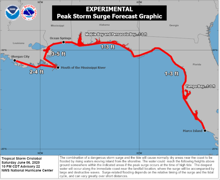
STORM SURGE: Perhaps the greatest impact of Cristobal will storm surge flooding near the center and far to its east along the coast. Peak storm of 3-5 feet above normally dry ground is expected along the coast from to Ocean Spring, Mississippi to the mouth of the Mississippi River. 2-4 feet or surge is expected west of the Mouth of the Mississippi River to Morgan City, Louisiana. 1-3 feet of surge all the way from Ocean Springs to Marco Island, Florida including all of the Alabama coast and the Northwest Florida coast. Dangerous Surf conditions will exist all along the Gulf Coast as well. An extremely dangerous rip current threat will exit through Tuesday.
STORM SURGE WATCHES AND WARNINGS:
A Storm Surge Warning is in effect for…
* Mouth of the Mississippi River to Ocean Springs Mississippi
* Lake Borgne
A Storm Surge Watch is in effect for…
* East of Morgan City Louisiana to the mouth of the Mississippi
River
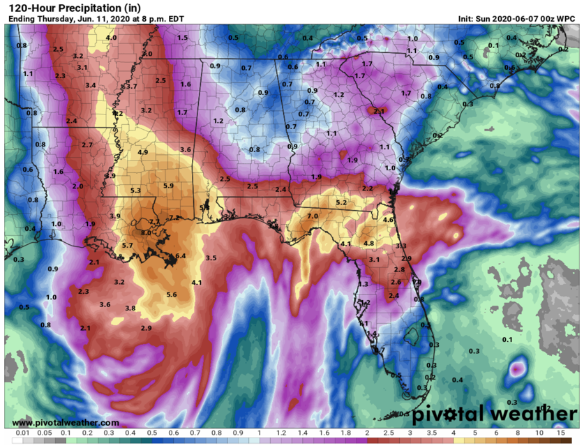
RAINFALL: Very heavy rainfall of 4-8 inches will fall near and well to the east of the track of the center across southeastern Louisiana, southern Mississippi, northern Florida, and extreme southern Georgia. 2-3 inches of rain will fall across southern Alabama and northwestern Florida. A strip of 1-2 inches of rain will fall across the western counties of Alabama including the cities of Hamilton, Tuscaloosa, and Greenville. These totals will be measured between now and Monday evening.
TORNADOES: Tornadoes are often a possibility in the outer feeder bands of landfilling tropical cyclones, and it appears that Cristobal will be no exception. The threat will be highly conditional, meaning it is will be based on the conditions that develop, and will be located where the feeder bands set up. The highest threat will definitely be closer to the Mississippi border and back into southeastern Louisiana and Mississippi. Hence, the threat is uncertain but definitely possible. The threat for Alabama will commence tonight and will last through much of Monday.
I will have a complete update on Cristobal by 7:15 in the morning with the Sunday morning edition of the Weather Xtreme Video.
Category: Alabama's Weather, ALL POSTS, Tropical
About the Author (Author Profile)
Bill Murray is the President of The Weather Factory. He is the site's official weather historian and a weekend forecaster. He also anchors the site's severe weather coverage. Bill Murray is the proud holder of National Weather Association Digital Seal #0001 @wxhistorianSubscribe
If you enjoyed this article, subscribe to receive more just like it.


