Sunday Weather Xtreme: Tropical Storm Cristobal Will Make Landfall Late This Afternoon in Louisiana
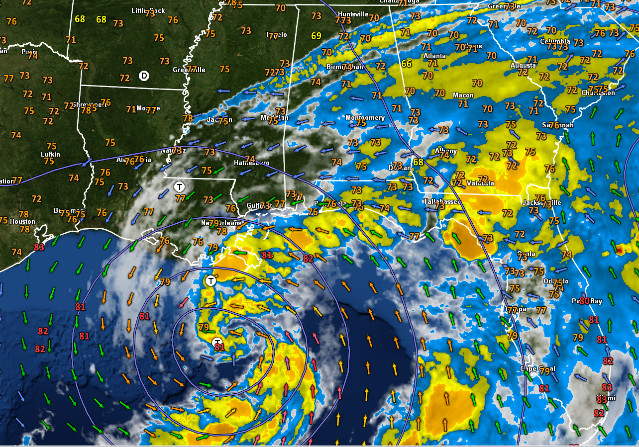
Tropical Storm Cristóbal is moving toward landfall on the Louisiana coast this evening as a disorganized but impactful storm. Most of the effects will be felt to the west of Alabama, but we will get some rainfall from the outer feeder bands and along with that, there is a chance of some tornadic activity. In our state, the closer you are to the Mississippi border, the greater the potential impact.
FAST FACTS ON CRISTOBAL AT 4 AM CDT
———————————————-
LOCATION…27.3N 90.1W
ABOUT 140 MI…225 KM SSW OF THE MOUTH OF THE MISSISSIPPI RIVER
MAXIMUM SUSTAINED WINDS…50 MPH…85 KM/H
PRESENT MOVEMENT…N OR 360 DEGREES AT 12 MPH…19 KM/H
MINIMUM CENTRAL PRESSURE…993 MB…29.33 INCHES
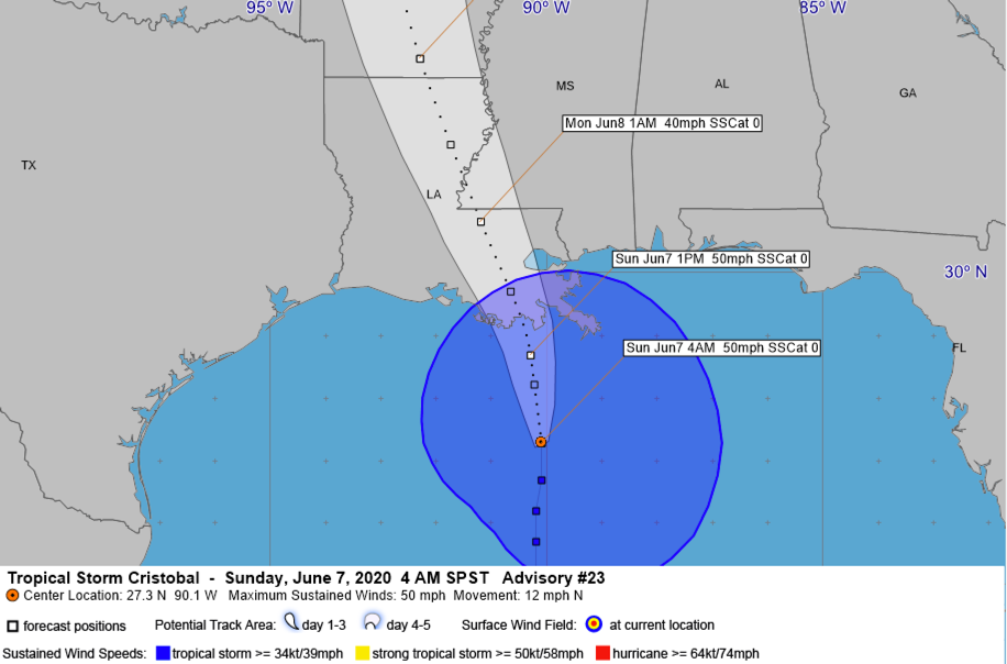
THE LATEST ON THE TROPICAL STORM: As of 4 am CDT, the center of Tropical Storm Cristóbal is located about 170 miles south southeast of Houma, LA, or about 190 miles south of New Orleans. It is moving north or north northwest at 12 mph. The storm has maximum sustained winds of 50 mph. Some slow strengthening is possible until the storm’s center moves inland this evening, but it is not expected to become a hurricane. That would happen if top winds reached 74 mph. It should make landfall between 5-7 p.m. this afternoon/evening between Grand Isle and Morgan City.
CURRENT WIND/SURGE WARNINGS:
A Storm Surge Warning is in effect for…
* Mouth of the Mississippi River to Ocean Springs Mississippi
* Lake Borgne
A Storm Surge Watch is in effect for…
* East of Morgan City Louisiana to the mouth of the Mississippi
River
A Tropical Storm Warning is in effect for…
* Intracoastal City Louisiana to the Okaloosa/Walton County Florida
** Including all of the Alabama coast as well as Pensacola, Navarre, and Fort Walton
* Lake Pontchartrain and Lake Maurepas
WINDS: Tropical storm force winds (39 mph or greater) will be reaching the coastlines of southern Louisiana, southern Mississippi, South Alabama, and Northwest Florida over the next few hours. Strong tropical storm force greater than 60 mph may affect a small area between Houma, Grand Isle, Slidell, New Orleans, Covington, and Gonzales. This area of strong tropical storm force winds will shrink this evening and should be gone by 9 p.m. or so as the storm weakens after landfall. But tropical storm force winds will be measured near and to the east of the center as far east as Southwest Alabama, as far north as Hazlehurst and Vicksburg in Mississippi, and to the Arkansas border in Louisiana. This includes cities such as New Orleans, Baton Rouge, Lafayette, Hattiesburg, Natchez, and Monroe. A National Ocean Service station at the Southwest Pass of the Mississippi River recently reported sustained winds of 47 mph and a wind gust of 62 mph at an elevation of 78 feet.
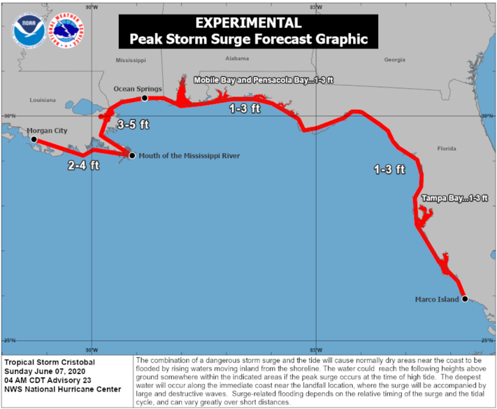
STORM SURGE: Perhaps the greatest impact of Cristobal will storm surge flooding near the center and far to its east along the coast. Peak storm of 3-5 feet above normal dry ground is expected along the coast from to Ocean Spring, Mississippi to the mouth of the Mississippi River. 2-4 feet or surge is expected west of the Mouth of the Mississippi River to Morgan City, Louisiana. 1-3 feet of surge all the way from Ocean Springs to Marco Island, Florida including all of the Alabama coast and the Northwest Florida coast. Dangerous Surf conditions will exist all along the Gulf Coast as well. An extremely dangerous rip current threat will exit through Tuesday.
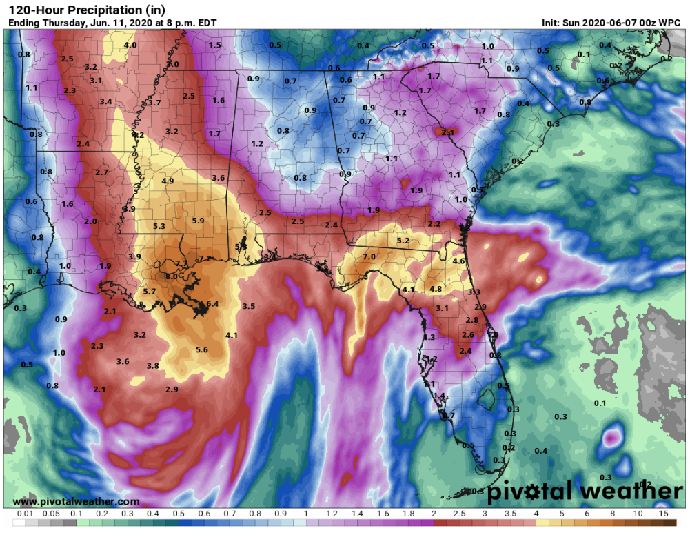
RAINFALL: Very heavy rainfall of 4-8 inches will fall near and well to the east of the track of the center across southeastern Louisiana, southern Mississippi, northern Florida, and extreme southern Georgia. 2-3 inches of rain will fall across southern Alabama and northwestern Florida. A strip of 1-2 inches of rain will fall across the western counties of Alabama including the cities of Hamilton, Tuscaloosa, and Greenville.
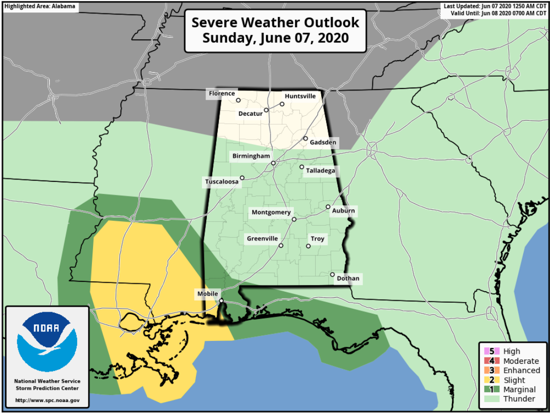
SPC Day One Severe Weather Potential Outlook through 7 a.m. Monday
TORNADOES: Tornadoes are often a possibility in the outer feeder bands of landfilling tropical cyclones, and it appears that Cristobal will be no exception. The threat will be highly conditional, meaning it is will be based on the conditions that develop, and will be located where the feeder bands set up. The highest threat will definitely back into southeastern Louisiana and Mississippi, but if one of those feeder bands works into western Alabama, we can’t rule out a couple of tornadoes. Hence, the threat is uncertain but definitely possible. The tornado threat for Alabama will commence tonight and will last through much of Monday.
BUT FOR YOUR SUNDAY: We are starting off warn and humidly across Alabama his morning. Temperatures are I the upper 60s north of I-20, and near 70F and into the lower 70s to the south. Some showers have been over South Alabama overnight but they have been losing steam as we get into the morning hours. High clouds started increasing last night and skies will trend to mostly cloudy at times today. This will keep high temperatures down jst a tad from where they might have been today, generally between 88-90F over North and Central Alabama with lower and middle 80s over South Alabama. A few of those showers may venture as far north as Clanton, Alex City, and Auburn by noon, but they will mostly be squashed by the combined effects of surface high-pressure ridging down from the Great Lakes and subsidence, or sinking air coming off the top of the tropical storm to our southwest. Today may be mostly dry north of Clanton. You will notice a decent easterly breezy at about 10 mph at times, thanks to Cristobal. Sunday evening may see a few showers breaking out, with lows in the middle 70s as muggier air inches into the state.
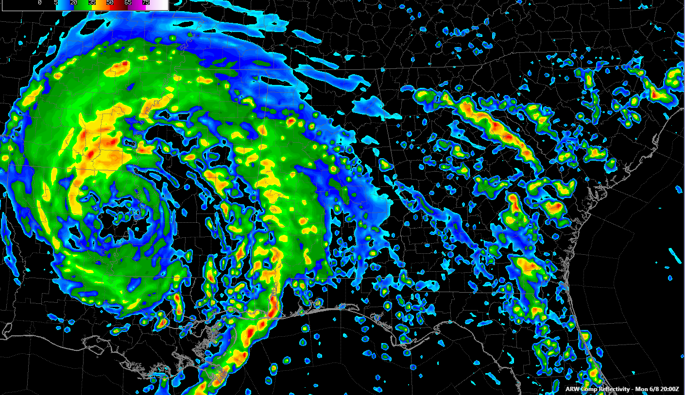
WRF model at 3 p.m. Monday setting up over West Alabama with potential for heavy rain and possible tornadoes.
TOMORROW: Tomorrow looks to be mostly cloudy with a freshening southeast breeze at 8-15 mph. It looks like an outer feeder band will work into western Alabama Monday afternoon and night, and this could be the main rain producer for Alabama. It could also bring that conditional threat of tornadoes. The highest chances for both will be in our western counties closer to the Mississippi border including places like Marion, Lamar, Fayette, Tuscaloosa, Pickens, Sumter, Hale, and Greene Counties. 1-2 inches of rain could fall in this area, with one inch or less to the east over to I-65 and less than that over eastern Alabama.
BY TUESDAY MORNING: The depression will be into southern Missouri, with a few scattered showers over West Alabama still. The system will be moving rapidly northeast by then. Alabama will find itself solidly in the moist airmass left behind and feeling the lift ahead of the approaching trough moving out onto the Plains. We should see even better chances of rain and storms on Tuesday and into Wednesday. A cold front will sweep through at some point Wednesday or early Thursday putting an end to the activity and setting the stage for a very pleasant…
…WEEKEND! Do what you wanna do, said Wet Willie in a famous song from the 70. And the weather will lonely be cooperative. Highs on Friday will be in the upper 80s and middle 80s by Saturday with dewpoints falling back into the 50s as a reinforcing shot of drier air arrives.
EXTENDED DRY PERIOD: We could be dry into the middle of the month, which will set those lawn sprinklers to whirring across the area as dryness builds. So hope we get come beneficial rains between now and Wednesday. I don’t have my hopes too high…
BEACHCAST: Rough weather along the beautiful beaches of Alabama and Northwest Florida. A friend asked earlier this week if they should cancel their long-planned beach trip to Destin and I told them no, because any day at the beach beats just about any day anywhere else. But stay out of the water. The rain chances will be high through Tuesday. It will be warm and humid. Winds will be strong out of the east, southeast and eventually south, occasionally gusting to tropical storm force. Tides will be 1-3 feet above normal. The rip current threat will be EXTREME. I am not making my case for this to be a good time to be at the beach, am I?
Click here to see the Beach Forecast Center page.
NATIONALLY: How about frost advisories and freeze watches for much of Nevada and southern Washington out West. Winter weather advisories are in effect for southwestern Montana and parts f Idaho where snow is expected in the higher elevations, including West Yellowstone. All thanks to that especially deep trough coming out of the West.
WEATHERBRAINS: This week, the panel will entertain the inventor of the RadarScope app that we all know and love, Mike Eilts. . Check out the show at www.WeatherBrains.com. You can also subscribe on iTunes. You can watch the show live at live.bigbrainsmedia.com or on James’ YouTube Channel You will be able to see the show on the James Spann 24×7 weather channel on cable or directly over the air on the dot 2 feed.
ON THIS DATE IN 1984: A major outbreak of tornadoes across the Upper Midwest. Twenty-one of them occurred in Iowa. The small town of Wright, Iowa was nearly wiped out by an F4 tornado that killed 2. Barneveld, Wisconsin was hard hit shortly before midnight by an F5 tornado. Nine people were killed and 197 injured. Ninety percent of the town was damaged or destroyed. Follow my weather history tweets on Twitter. I am @wxhistorian at Twitter.com.
Category: Alabama's Weather, ALL POSTS, Tropical
About the Author (Author Profile)
Bill Murray is the President of The Weather Factory. He is the site's official weather historian and a weekend forecaster. He also anchors the site's severe weather coverage. Bill Murray is the proud holder of National Weather Association Digital Seal #0001 @wxhistorianSubscribe
If you enjoyed this article, subscribe to receive more just like it.


