Quick Update at 3 p.m.: Cristobal Wobbling Near Shore, Rain/Wind Battering the Mississippi, Alabama, Florida Coasts
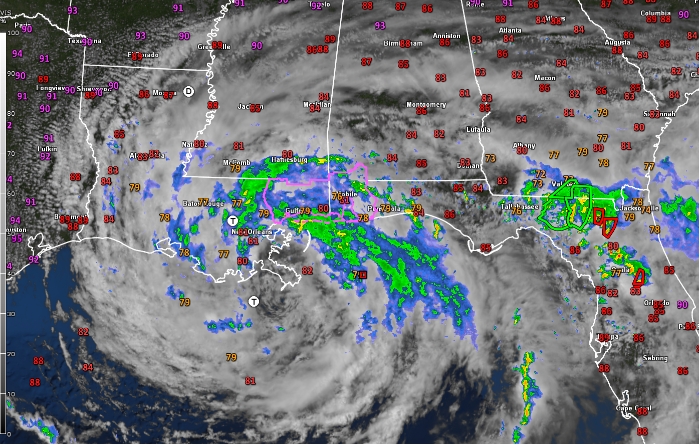
The large center of Tropical Storm Cristobal is approaching the Mouth the Mississippi River at this hour as the system was been wobbling a bit to the north or northeast. There is a small low-level swirl inside the larger partially clear center that could be thee ara of lowest pressure. Blue skies are showing up overhead at Grand Isle, where much of the town is underwater.
There is no Air Force reconnaissance plane in the storm at this time.
Winds are quite strong along the Mississippi and Alabama coasts at this time. Winds are gusting to 47 mph at Gulfport at this time our of the east. Mobile’s Downtown Airport (formerly Brookey Field) had a peak gust of 40 mph at 2:29.
A heavy rain band is now spreading across the New Orleans and Northshore area of Lake Ponchartrain across the Mississippi Coast, coming onto the Alabama coast and into the Pensacola area. Just north of that, a defined feeder band extends from south of Atmor in Alabama to Fort Walton Beach. I wouldn’t be surprised to see a tornado warning pop up from that band.
Storm surge is now 5.1 feet a Waveland. Water has completely covered the beach there.
A feeder band over northern Florida is prompting tornado warnings for two well-defined signatures there. One is passing just east of Lake City. The other is between Ocala and Orlando.
Further northward, there is no storm activity over North or Central Alabama. Any activity is being suppressed by the sinking air around the periphery of the tropical storm. That feeder band over South Alabama may work up into Central Alabama late this afternoon and evening. Rain near the coast will work its way into southwestern sections of Central Alabama from Montgomery up to about Tuscaloosa into the evening hours. During the hours after midnight heavy rain and wind will spread into southern Mississippi in the areas from Jackson to Brookhaven and Hattiesburg. Showers wil move northward through Central Alabama during the overnight hours as well, bt they won’t be as heavy.
Heavy rain will be moving northward through much of Mississippi, Arkansas, northern Louisiana with some showers and storms into Central Alabama. Highs will be in the middle 80s and it will be quite humid. Any storms that get organized along feeder bands that manage to work their way into western Alabama could rotate and could produce tornadoes. We will even be watching any feeder bands across the rest of Central Alabama that get organized.
As the low starts moving northeast through Iowa on Tuesday, Alabama will be in the warm, humid airmass left behind, and we will see fairly numerous showers and storms develop by afternoon. Rain chances will be fairly high. Highs will be in the upper 80s.
The deep upper trough out west will have swept the remnants of Cristobal into Canada and will be pushing a frontal system our way on Wednesday with the main effects being some drier air for the weekend. There will be more rain and storms on Wednesday ahead of the storm.
Then, expect dewpoints in the 50s at times Thursday through Saturday. Dry conditions will prevail starting Thursday and lasting for several days. We may not see rain again until the weekend of the 20th.
Category: ALL POSTS
About the Author (Author Profile)
Bill Murray is the President of The Weather Factory. He is the site's official weather historian and a weekend forecaster. He also anchors the site's severe weather coverage. Bill Murray is the proud holder of National Weather Association Digital Seal #0001 @wxhistorianSubscribe
If you enjoyed this article, subscribe to receive more just like it.


