

Strong Storms Affecting Bibb, Jefferson, Shelby, & Tuscaloosa Co.
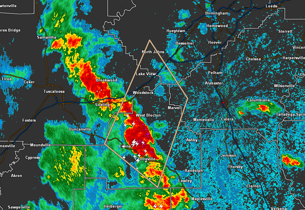
…SIGNIFICANT WEATHER ADVISORY FOR SOUTHEASTERN TUSCALOOSA…WEST
CENTRAL SHELBY…CENTRAL BIBB AND SOUTH CENTRAL JEFFERSON COUNTIES
UNTIL 415 PM CDT…
At 346 PM CDT, Doppler radar was tracking strong thunderstorms along
a line extending from near Vance to near Centreville. Movement was
north at 40 mph.
Winds in excess of 40 mph will be possible with these storms.
Locations impacted include…
Brent, Centreville, Lake View, Vance, Woodstock, West Blocton, North
Johns, Tannehill Ironworks State Park, West Centreville, Eoline,
North Bibb, Bucksville, Weller, Marvel, Bibb County Airport, Green
Pond, Pearson, Caffee Junction, Hebron and Harmon.
PRECAUTIONARY/PREPAREDNESS ACTIONS…
To report severe weather, contact your nearest law enforcement
agency. They will relay your report to the National Weather Service
office in Birmingham.
Category: Alabama's Weather, ALL POSTS, Severe Weather, Tropical
About the Author (Author Profile)
Scott Martin is an operational meteorologist, professional graphic artist, musician, husband, and father. Not only is Scott a member of the National Weather Association, but he is also the Central Alabama Chapter of the NWA president. Scott is also the co-founder of Racecast Weather, which provides forecasts for many racing series across the USA. He also supplies forecasts for the BassMaster Elite Series events including the BassMaster Classic.Subscribe
If you enjoyed this article, subscribe to receive more just like it.


