It’s Summertime, Summertime, Sum, Sum, Summertime!
Summer officially arrived Saturday afternoon and it felt like it across Alabama, with highs reaching well into the 90s. It was 91F at Anniston, 92F at Calera, 93F at Tuscaloosa, 94F at Birmingham, and 95F at Troy. The average high for Birmingham for today is 89F, which is right about where we will be today. Let’s walk through the forecast for this first week of summer.
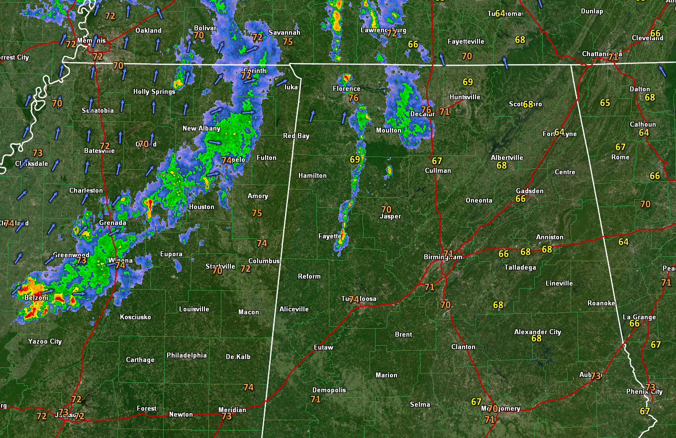
RADAR CHECK: A line of showers is moving through North and Central Alabama this morning. It extends from Decatur down to Jasper. It will affect parts of Madison, Morgan, Cullman, Walker, northern Jefferson, and Blount Counties over the next hour.
ON THE WEATHER MAPS: A broad trough covers much of the United States this morning. Embedded in that large trough are a couple of shortwave troughs, one to our east, and one passing to our north today. At the surface, high pressure over the Atlantic is ridging across Florida. To the west, pressures are lowering across the Plains states. Moisture levels are increasing rapidly to the west of Alabama, and that trend will spread into western Alabama today. This will help showers and storms develop today, and that will be a trend over the week ahead.
FOR YOUR SUNDAY: Today will feature partly sunny skies, with highs in the upper 80s to near 90F, and humid feeling dewpoints in the upper 60s, which will feel quite muggy. Showers and storms will form this morning and continue through the afternoon and into the early evening as a dying round of storms moves in from Mississippi. The chance your backyard will get wet is about 1 in 2. If you’re lucky enough to get under a shower or storm you can pick up half an inch of rain quickly, but plenty of folks will get nothing today as well. Lows tonight will drop into the upper 60s to near 70F.
THE NEW WORK WEEK: Alabama will remain in a warm and humid airmass tomorrow. Scattered showers and storms will develop again, with coverage about like today. Southwesterly winds will get a bit gusty at times as the pressure gradient tightens between the high to the east and lowering pressure to the west. Highs will top out in the upper 80s to near 90F.
TUESDAY/WEDNESDAY: By Tuesday, a stronger trough will be marshaling its forces over the Midwest. This trough will progress eastward, increasing our rain chances. Scattered showers and storms will form again Tuesday afternoon, but a more substantial round of showers and storms will move into Alabama late Tuesday night and Wednesday morning. The frontal boundary will sink to around I-20 by Thursday morning, but that will be about as far as it will get. Highs Tuesday will be in the mid and upper 80s, and in the lower and middle 80s on Wednesday.
THURSDAY: With the boundary hanging around and getting ready to come back north as a warm front, rain chances will still be in the forecast. Highs will be in the middle 80s.
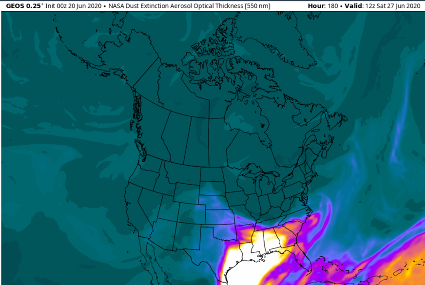
SAHARAN DUST: A huge amount of Saharan dust is moving across the Atlantic right now and some of that will work into Alabama and the Southeast by next weekend.
WEEKEND OUTLOOK: It looks like the dust might put the kibosh on our shower and storm chances for the weekend. It will be hot and humid with just isolated showers and storms each afternoon.
VOODOO TERRITORY: The Fourth of July weekend looks wet for now. It won’t be a total washout, but there will e a good chance of showers and storms with typically hot and humid conditions.
BEACHCAST: Fairly typical weather along the beautiful beaches of Alabama and Northwest Florida over the week ahead. It will be partly cloudy, warm, and humid. Highs will be in the upper 80s. Lows will be in the upper 70s. Water temperatures are in the lower 80s. The rip current risk will be low for the foreseeable future.
Click here to see the Beach Forecast Center page.
WEATHERBRAINS: This week, the panel will be talking about sheltering in the face of tornadoes and hurricanes in the face of the Covid-19 outbreak. Check out the show at www.WeatherBrains.com. You can also subscribe on iTunes. You can watch the show live at live.bigbrainsmedia.com or on James’ YouTube Channel You will be able to see the show on the James Spann 24×7 weather channel on cable or directly over the air on the dot 2 feed.
ON THIS DATE IN 2003: A small tornado toppled the middle portion of the historic Kinzua Viaduct near Mount Jewitt, PA. Once the tallest and largest railroad bridge in the world, the 310 foot high, one half mile long railroad bridge, still ranked as the fourth-longest in the U.S. before it fell. Regarded by some as the Eighth Wonder of the World after it was constructed in 1882, the bridge accommodated its last freight train in 1959. Officials had closed the bridge to pedestrian traffic in 2002 over fears that a high wind whipping through the valley could cause a section to collapse. Follow my weather history tweets on Twitter. I am @wxhistorian at Twitter.com.
Category: Alabama's Weather, ALL POSTS
About the Author (Author Profile)
Bill Murray is the President of The Weather Factory. He is the site's official weather historian and a weekend forecaster. He also anchors the site's severe weather coverage. Bill Murray is the proud holder of National Weather Association Digital Seal #0001 @wxhistorianSubscribe
If you enjoyed this article, subscribe to receive more just like it.


